In early May IDV
Solutions rolled out Visual Fusion 4 (press
release). If you check the calendar, Visual Fusion 3 dates back
only a year, to 2008. Everything seems to move quickly at the 30-person
company launched in 2004. In just four years the company transitioned
from a service provider with some in-house technology to a technology
platform provider with a dozen implementation partners. One of those
partners licenses and promotes the technology, too; that company is
called Microsoft.
So, what is Visual Fusion? I'd describe it as a solution for integrating geodata and services (especially those of SharePoint) into map-focused applications. IDV doesn't use the term GIS in describing the solution. Instead, if pressed, CTO Ian Clemens describes IDV Solutions as a "mashup company." With clients like NGA, Toyota, the United Nations and NYPD, that seems a bit too informal, though it is technically accurate.
After exploring Visual Fusion 4 with Clemens and IDV Solutions President Mark Morrison, I'd describe it as having two modes: one for building applications and one for using those applications. The Application Hub, basically a library, manages existing apps and allows those with appropriate credentials to build new ones. The application creation tool has been revamped in VF4 and includes a SharePoint-based workflow, basically a wizard that walks the user through setting the parameters for a new application.
We built one to explore the H1N1 virus. After defining some basics (name of the app, thumbnail picture, access details) we set the base geography in Virtual Earth to focus on the United States. Then it was time to add in data layers - both internal ones such as Excel spreadsheets and others from MapPoint Web Services including the locations of hospitals. We also added a KML file of reported cases we found on the Web. Each of these data layers could be styled with ease. All of these data were "live." For example, if the network KML file was updated, our map would update. Similarly, if someone checked out, changed and checked in the Excel spreadsheet, its point locations would be updated on the map.
The visualization in Visual Fusion 4 is done using Silverlight, which the IDV team praises for its freedom and flexibility. Version 4 also integrates Web search and SharePoint search.
From Morrison's comments, I conclude that many potential business geospatial technology users are still struck by the power of seeing their data on a map. "I look at tables all day" he paraphrased one prospect, "but the maps tell me more." It's my sense that the introduction of Visual Fusion as a layer on top of in-place data and tools (like SharePoint) does not threaten prospects in a way GIS might have in the past. The basemaps look familiar, as do the tools to build the applications. Further, there are no new terms to learn.
Visual Fusion 4 might be described as a geospatial glove that slides over existing technology and datasets to reveal what lies beneath.
So, what is Visual Fusion? I'd describe it as a solution for integrating geodata and services (especially those of SharePoint) into map-focused applications. IDV doesn't use the term GIS in describing the solution. Instead, if pressed, CTO Ian Clemens describes IDV Solutions as a "mashup company." With clients like NGA, Toyota, the United Nations and NYPD, that seems a bit too informal, though it is technically accurate.
After exploring Visual Fusion 4 with Clemens and IDV Solutions President Mark Morrison, I'd describe it as having two modes: one for building applications and one for using those applications. The Application Hub, basically a library, manages existing apps and allows those with appropriate credentials to build new ones. The application creation tool has been revamped in VF4 and includes a SharePoint-based workflow, basically a wizard that walks the user through setting the parameters for a new application.
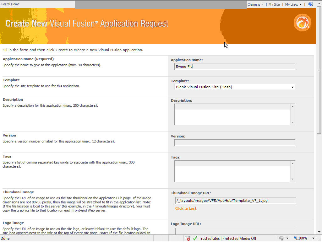 |
We built one to explore the H1N1 virus. After defining some basics (name of the app, thumbnail picture, access details) we set the base geography in Virtual Earth to focus on the United States. Then it was time to add in data layers - both internal ones such as Excel spreadsheets and others from MapPoint Web Services including the locations of hospitals. We also added a KML file of reported cases we found on the Web. Each of these data layers could be styled with ease. All of these data were "live." For example, if the network KML file was updated, our map would update. Similarly, if someone checked out, changed and checked in the Excel spreadsheet, its point locations would be updated on the map.
The visualization in Visual Fusion 4 is done using Silverlight, which the IDV team praises for its freedom and flexibility. Version 4 also integrates Web search and SharePoint search.
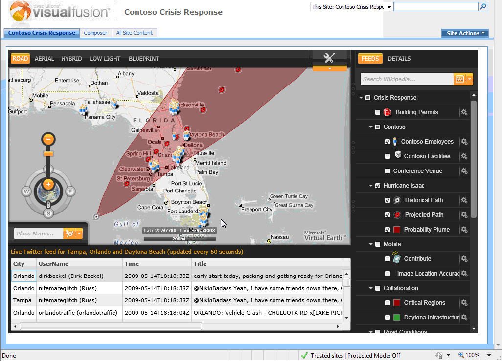 |
From Morrison's comments, I conclude that many potential business geospatial technology users are still struck by the power of seeing their data on a map. "I look at tables all day" he paraphrased one prospect, "but the maps tell me more." It's my sense that the introduction of Visual Fusion as a layer on top of in-place data and tools (like SharePoint) does not threaten prospects in a way GIS might have in the past. The basemaps look familiar, as do the tools to build the applications. Further, there are no new terms to learn.
Visual Fusion 4 might be described as a geospatial glove that slides over existing technology and datasets to reveal what lies beneath.
From Our Homepage
Saying Farewell to an Amazing Journey
Communicating with Maps
Is There a GIS Career Ladder?
What does it mean to be geospatially smart? Series
Ways Real Estate and Property Developers Utilize Melissa GeoData for Data-Driven Decisions
Unlocking Value From Daily Satellite Imagery and Insights
Maximizing the Value of Your Address Data with Geo Addressing
How Indoor Mapping Enhances the Security of Smart Buildings
Look Ahead: AI, Location Intelligence and Efficiency
Collaboration Takes on Sea Level Rise & Dynamic Technology Environments
Brownies for Brownfields
Has Everything Been Mapped Already?
How Is Data Literacy Changing in an Artificial Intelligence Landscape
Portfolios for GIS Professionals: More Than Just Maps
How to Create a Distance Matrix in QGIS - A Step-by-Step Guide
7 Ideas for Bringing GIS into the K-12 Classroom
The Geography of Movement