The quiet hamlet of Westport in the West of Ireland recently received support from Google to create an interactive 3D digital town on Google Earth. The "Westport 3D" project was produced by AMT3D, a digital computer modeling firm. With the help of Daniela Brica, Google Earth's senior associate and 3D captain for Europe, Middle East & Africa, AMT3D launched this effort to help Westport's town council with numerous applications such as urban design, planning and tourism. Editor-in-chief Joe Francica talked with Dr. Brendan Hafferty, director of AMT3D, about the project:
Joe Francica (JF): Was the development of an "interactive 3D digital town on Google Earth" the result of a previously developed database of geospatial data captured using GIS or CAD software solutions that were ported to KML and exposed using a Google Earth API? Which GIS and spatial databases were you using prior to this effort?
Brendan Hafferty (BH): Yes. We were commissioned to produce the Westport Master model by the Westport Town Council. We made this available on CD using an interactive games engine navigator / viewer and also on the Web via a VRML-based hosting system. The workflow goes something like this: Spatial and photographic data capture, point cloud digitization, photographic texturing, output in .Max format, embedded into the particular viewer / navigation system of the clients' choice. Google Earth engineers in the U.S. ported the .Max version of the Westport 3D model into KML and will host it accordingly.
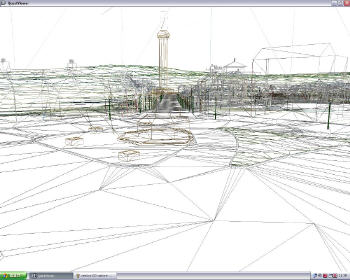
This is part of the wire-frame which is the result of digitizing the merged point clouds prior to texturing. (Click for larger image) JF: Who was the visionary or champion who developed the idea to use Google Earth for urban design, planning and tourism? Was the motivation behind this effort political, cost saving, service to the citizenry, tourism?
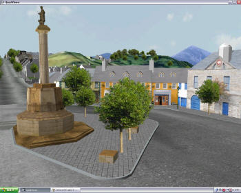
A view of the Octagon with the Holy Mountain of Croagh Patrick in the background. The Octagon is the main "square" in Westport which is dominated by a statue of St. Patrick atop a large column. (Click for larger image) BH: Google Earth, in the form of their senior associate responsible for 3D within Europe, Asia and Africa (Daniela Brica), approached AMT3D after seeing Westport3D online and asked if we would like it on Google Earth. The launch of this has been delayed until the aerial imagery of the target area in and around Westport and the Holy Mountain of Croagh Patrick had been improved - which it now has. If there was a visionary, then it was me - and we've only just started!
JF: What specifically was the technology used that you describe in the press release as "the latest long distance laser scanning technology." LiDAR?
BH: The data capture is performed using a Riegl long distance laser scanner (ground based LiDAR) linked to high resolution digital photography.
JF: Who will use the new application? Is it just the Westport town council?
BH: Westport3D is being used by the town council and also local developers who are involved in the rapid growth of this West of Ireland town. In addition, various local businesses are interested in using the interactive online model to promote their individual enterprises - especially as we can place links within the model from their shop doors to digital objects such as Web hyperlinks, audio streams, etc. These businesses include restaurants, hotels, etc. The model is also being used by the council to increase tourism within the area. This aspect of the model will increase enormously as we go live on Google Earth and also the other four phases of the Westport Master model are completed and hosted online.
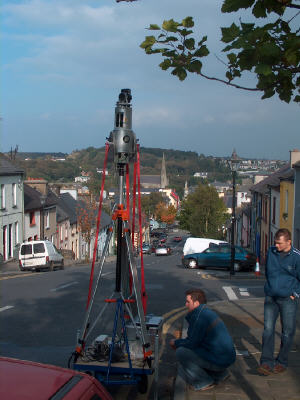
Two AMT3D engineers operating the long distance laser scanner and integrated digital camera on Tubber Hill in Westport overlooking the Octagon. (Click for larger image) JF: They do, indeed, have an "exceptional planning and 3D design environment tool." Do you consider this a building information model that will be used by architects and engineers? Will the architects and engineers use a different CAD tool like AutoCAD to add to the model or will they develop in SketchUp?
BH: The Westport3D Master Model is already in use by the town architects and engineers. The model already contains a number of 3D CAD models that have been inserted into the master model to show the planners and the general public what these new schemes would look like in the context of the existing urban environment, thereby allowing stakeholders to experience the proposed new buildings in a way previously not possible. The ability to switch, onscreen and at the click of the mouse, between what a streetscape looks like now and what it could look like is seen by everyone who has seen it as an extremely powerful planning tool.
JF: How do you envision using the new Google Earth application in designing a "future urban environment in 3D," and will Google Earth become your new platform to visualize all geospatial data such as demographics, tax maps, school zones, etc.?
BH: See above for some of the tremendous benefits of photo-realistic and architecturally accurate 3D interactive digital city models and streetscapes and apply it to a worldwide viewing engine such as Google Earth. Will it become our new platform? Only time will tell.
JF: Post-launch, you say that the Westport3D model can be viewed via Google Earth and will be searchable. How much will you expose to the world, and are you concerned about certain privacy issues regarding parcel level information?
BH: All of it. It's controlled by Google Earth.
JF: Will you have a private enterprise Google Earth platform just for city planners that will not be exposed to citizens or tourists?
BH: Yes and no. The city planners et al. will (do) already have an interactive editable copy prior to it being hosted on Google earth.
JF: What do you envision as other possibilities for this application?
BH: [We see] Heritage Tourism; Commercial Advertising; Strategic Security and Emergency Planning; Facilities Management; to name but four!