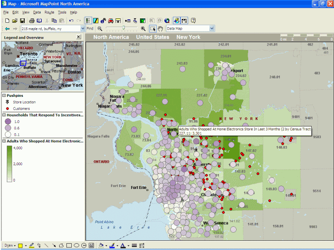
The basemap, demographic, and point-of-interest data in the product is all new.As our customers know, a mapping tool is only as good as the data that ships with it.MapPoint 2004 for Europe and North America includes the latest data available from our data suppliers.We've also added consumer profile data, ideal for market analysis where understanding buying patterns and consumer behavior is needed.For instance, with just a few lines of code you can include a shaded map in your application indicating where households have cable TV versus satellite television, which is highly valuable for someone in the Cable industry planning a marketing campaign focused on winning new business.MapPoint 2004 also has support for more GPS (Global Positioning System) devices, as well as real-time GPS positioning.The enhanced GPS support, combined with some existing features such as multipoint driving directions optimization, 'do not drive' zones, drive time polygons, and yellow page listings make MapPoint a great tool in the fleet management industry.
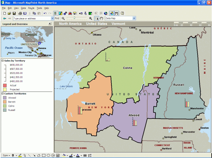
Click for larger image
What can developers do with MapPoint 2004?
There are two ways a developer can leverage MapPoint 2004 in their
applications.First off, it is very easy to use Visual Basic for Applications
(VBA) to quickly customize the UI.This is a great way to go if the MapPoint
'out of the box' User Interface is close to what you need, and you are
simply looking to create some custom dialogs or automate some tasks such
as data import.Second, the included MapPoint ActiveX control allows you
to build mapping into standalone applications.Using the ActiveX control,
we've seen some developers and ISV's build some really killer vertical
applications for industries such as Crime Analysis, Advertising, Insurance
and Home Delivery just to name a few.Whatever approach you take, you have
programmatic access to all of MapPoint's rich functionality.For instance,
it's very straightforward to write a custom application that reads sales
data from a SQL database or local datasource such as an Excel spreadsheet,
and have MapPoint generate a thematic map showing territories where sales
are strong.Imagine an executive dashboard that showed underperforming
markets in real time or a dispatch system that optimized a fleet of driver's
daily routes.And remember, if MapPoint 2004 doesn't meet the requirements
of your development project, the MapPoint Web Service may fit the bill.

What is the MapPoint Web Service? How does it differ from MapPoint
2004?
The MapPoint Web Service is a hosted XML Web Service that exposes its
functionality via a SOAP API.It's loaded with features including interactive
mapping, driving directions, geocoding, reverse-geocoding, and much more.
Basically, all of the functionality and geographic data needed in most
Location-Based applications can be found here, without the expense and
complexity of building this infrastructure yourself.Developers simply
add the MapPoint WSDL to their Visual Studio .NET project and begin coding!
Geographic applications that took weeks or months are now handled in days.
The MapPoint Web Service is of course the perfect tool for any web-based
application such as a store locator, but what a lot of developers forget
is that it's also ideal for any other device or platform thanks to the
fact it is an XML Web Service - From a Visual Basic application for Windows
to a C# application running on the .NET Compact Framework for Pocket PC's,
MapPoint's Single API has you covered.Integrating the element of location
in existing applications, regardless of their architecture, is now brain-dead
easy.
Click for larger image
What about performance and scalability?
We back the service with an aggressive SLA (Service Level Agreement)
that guarantees our uptime and performance.The Service has been live for
general consumption for nearly 2 years, and is currently handling over
15 million transactions every day! Some of our largest customers throw
a billion requests per year at the service.As more and more customers
come on board, the MapPoint operations team builds out the cluster as needed
to support the traffic.This saves our customers the huge expenses associated
with traditional GIS solutions.The great thing about this model is that
the same service that supports these mega web properties can be used by
developers of applications with much more modest needs - and since you
pay for just the transactions you use, it remains totally cost effective.
Tell us a bit about MapPoint Location Server.
Glad you asked.We anticipate shipping Microsoft Location Server (MLS)
in early 2004.In all of my years working with Location Technologies, this
is the first product that I've seen with the potential to really change
our lives - how we socialize, work and interact with each other.I know
that's a bold statement, but it's really indicative of the level of excitement
coursing through our group these days! The initial release is focused on
enterprise customers who want to track mobile assets to solve business
problems - Where are my delivery trucks? Who is in the best position to
pick up a certain passenger? Where are my friends so we can get together
for a drink? Some non-business problems as well I suppose!
To illustrate, here is a simple web application that I built - http://www.whatididwaswrong.com/whereissteve.It displays an interactive map centered wherever my mobile phone happens to be.Seems sci-fi like, but the guts are just 5 lines of Visual Basic!
MLS has a 'plugin' architecture that allows it to interface with any
source of real-time location information.Today we're focused on Plugins
for mobile phone networks, but think of all of the sources of real time
location around you - Wi-Fi Hotspots, your Outlook calendar, GPS, etc...
It is possible for MLS to interface with all of these and more.
What do you have planned for the future of MapPoint Technologies?
Our team is really focused on delivering the same mapping and location-based
technologies experience on any device or platform, wherever and whenever
it's needed.Perhaps more importantly, we're committed to making it easy
for 3rd party developers to use our tools to do the same thing! To that
end, you're going to see more slick end-user applications that leverage
the MapPoint Web Service across different devices.