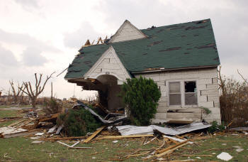
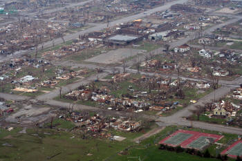
The stories in newspapers nationwide said: "At 9:45pm on Friday, May 4, 2007, the lives of the nearly 1400 citizens of Greensburg, Kansas were changed forever." What they should have said was: "What happened on May 4, 2007 will change the lives of 2.7 million people forever." Why? Because the entire state of Kansas will feel the impact of the awesome tornado that devastated the town - today, tomorrow, and for years to come. This story is to exemplify the obstacles that a few of our fellow Kansas Association of Mappers (KAM) members had to face in order to "rebuild" the city.
 |
Well before the storm hit, the National Weather Service (NWS) informed residents that they were under an unusual "Tornado Emergency." NWS predicted the exact path of the storm, directly through the small town of Greensburg. Tornado sirens sounded 20 minutes before it actually hit. The tornado, which started 13 miles south of Greensburg and destroyed homes throughout Kiowa County, grew into a two-mile wide monster, with a path of destruction that stretched for 22 miles.
There were a total of 12 tornadoes that hit Kansas on May 4th. The tornado that formed just northeast of Greensburg was rated as a strong EF5 tornado, with winds reaching speeds of up to 205 miles per hour. According to the NWS, the tornado that hit Greensburg was the first "5" rating on the recently enhanced Fujita Scale and the first "5" classification since May 3, 1999, when an F5 tornado ripped through the Oklahoma City area, killing 36 people. The series of tornadoes from Friday night through the weekend left 12 people dead in Kansas, nine in Greensburg alone.
D.J. McMurry, the appraiser for nearby Pratt County and a member of KAM, arrived 10 minutes after the tornado tore through the small southwestern Kansas town. Though McMurry works in Pratt, he lives just outside Greensburg on a farm. He has family who also live there, his father and a brother, both of whom lost their homes to the storm. In the blackness of night, he was fortunate to find his family members. He said, "You may end up helping two or three people, just trying to find your own family - it was very difficult."
 |
Once he made sure his family was safe, McMurry headed back to his farm. Although a mandatory evacuation of the town was ordered shortly after the tornado hit, he drove his skid loader back to town and began clearing debris from whatever streets he could access. McMurry said that a person could not go anywhere - trees, telephone poles and house debris covered the streets, making it virtually impossible to drive a normal vehicle through. He helped move debris and helped families in need as much as he could, well into Saturday morning.
Even the street markers were gone - the city's residents were unsure where things used to be, let alone the multitude of emergency personnel and volunteers from neighboring counties. McMurry had the same problem. He has lived there his entire life, but said when he was traveling down Bay Street, which forms the town's western border, he got lost two or three times. There were no buildings left - he had no sense of direction, no landmarks to reference. Before the tornado, he knew where residents' homes were just by sight; he knew how to get there by knowing where to turn, not necessarily by street name. That night, he couldn't tell one home from the next because of the destruction.
Fellow KAM member Bruce Hardesty called McMurry at 10:30 that night to see if he was alright. McMurry called him back at 2:00am to say his farm had not been hit by the tornado. Hardesty told him that if he needed any help to please give Hardesty a call. At 1:30pm Saturday afternoon, McMurry did exactly that - he called Hardesty and said that they needed maps. Hardesty told him he would get to the office in about 10 minutes. Martin Bieker, Technical Services manager with R&S Digital where Hardesty also works, met him at their office in Great Bend.
Hardesty began downloading data from DASC, the Data Access & Support Center located in Lawrence, Kansas. Hardesty and Bieker began transferring the TIGER street data files, KDOT highways and 2006 NAIP one-meter color orthophotography to his computer - anything that would show Greensburg and/or Kiowa County and could be used to create a map. There was no information specifically relevant to Kiowa County or to Greensburg itself, such as parcel data. He was unable to obtain any additional photography other than the DOQs or U.S. Agriculture aerials, which are not sub-meter resolution.
The data was emailed to McMurry in Pratt and he began putting the information together into a GIS - something from which a map could be created and plotted. Hardesty and Bieker arrived in Pratt later Saturday afternoon and met with McMurry, after downloading the available 2002 DOQs and 2006 NAIP photography. They brought all the information on DVDs, just in case it needed to be sent elsewhere.
The plotting of maps ended up taking nearly 25 minutes per page, so due to time restrictions, McMurry and Hardesty decided to make copies of one map on a large-format copier and get them out to the field. Those crude maps, with the TIGER files, road names and NAIP photography, were given to emergency officials Saturday night. They later heard stories of the rescue crews and other volunteers taping those and other old maps together on the floor of the FEMA trailer to create a larger-scale and "useable" map.
Saturday night brought even more tornado scares. The dryline that brought the initial tornado Friday night stayed along the same path. The Saturday storms spawned a few more tornadoes; luckily they were all away from Greensburg. The recovery efforts were discontinued, and a mandatory evacuation was set into place, just in preparation for more severe weather.
Sunday, May 6th was a sort of "sit-and-wait" day for Hardesty and McMurry. They continued to create more maps - newer maps with even more data, but still using DASC data. Those maps were also printed, copied and provided to personnel on-site in Greensburg Sunday morning. Hardesty and McMurry knew what they needed to do - build better maps with data from inside the Kiowa County Courthouse.
There followed a frantic period of trying to piece together any data they could get their hands on. They were eventually able to get into the courthouse and scan some 100- and 400-scale mylar tax maps they found. They also found a harddrive containing Year 2000 aerial photography. But this was incredibly difficult to do, and there was absolutely no metadata.
Wednesday morning, Hardesty brought with him to Greensburg a multitude of plotted maps that Bieker had created - maps that could actually be used in the field without having to tape them together. Hardesty and McMurry spent part of the morning handing out the maps they had created to the search and rescue crews, FEMA and other organizations. They had created more detailed maps for the city of Greensburg than had ever been available before.
Kansas Gas Services (KGS) in Topeka was also able to provide some data, once personnel there understood it was for a rescue effort. "In an emergency situation you have to have this kind of reciprocation from everyone involved," remarked Hardesty. "Without their data, we wouldn't have had addresses for the buildings - no way to make a logical kind of map that could be used on the ground. We just needed to get in contact with the right person!"
So, the question remains: Will the problems that McMurry and Hardesty encountered during the Greensburg mapping situation - having to frantically piece together whatever they could get their hands on - provide a much-needed drive for other counties in Kansas to "get on the ball"?
"There needs to be a push to get all local GIS data in the state of Kansas to DASC," Hardesty persisted. "A lot of counties have the ˜I paid for this, it's mine' mindset. A lot of counties say, ˜We have a GIS,' when they really don't have a working GIS. Then there are the ones that do have a viable GIS and they're just reluctant to give out what they do have."
Hardesty continued, "If you're going to have a GIS in a county, somebody needs to be able to show more than just a pretty map on the wall. County officials aren't technical enough to know the difference between having people that work for them with the GIS software and having an actual working GIS. The way they see it, as long as a map can be produced - they have a GIS. What you can pull from DASC right now for Kiowa County just isn't enough to produce something that is needed in the time of emergency. We proved that DASC needs more local county data."
"I want everybody to understand that ˜storing offsite' doesn't mean storing over at the local bank; you need to be storing off at another county," said McMurry. "But, if you don't have any data, it wasn't there in the first place. And if you do backup your data, putting that backup CD down at the local bank obviously won't do any good if the bank is blown away too."
"What people need to understand is that every document needs to be scanned and put on some kind of media and stored somewhere," continued Hardesty. "It's a must, because how that building [the courthouse] stood is amazing, with most of its contents intact inside." Both Hardesty and McMurry assisted in boxing up documents and other items from the courthouse, including the rack with the mylar tax maps they had scanned. The temporary Kiowa County Courthouse has been set up in nearby Mullinville, about 10 miles away.
Discussion has already begun related to creating a type of "mobile mapping center" that can quickly respond in the event of an emergency such as Greensburg experienced. Hardesty had a suggestion on the proper way to operate a mapping center: "You need to keep the people to a minimum," he said. "Five people max to do what we [McMurry and Hardesty] were doing, including two GIS-trained mapping technicians sitting there, and their only job is to make maps." People (emergency services, federal officials, etc.) can then come over to the center and request maps for their specific needs.
"But, it goes further than that; people need to first be familiar with what data they have available and provide whatever they have to DASC. DASC can be relaying what information is available. We know what DASC has, but only what is made public, and we use it on a regular basis. DASC can stay there; they can get the data ready to give out; they don't need to get out on the disaster site. If it's data that's not accessible to the public, somebody needs to be there in Lawrence so they can put it out on an FTP site, email, DVD, etc.," said Hardesty.
"I just don't understand why there isn't more reciprocation between our counties, our cities and DASC," McMurry said. "Cities might say they're ˜mapped", but what does "mapped" mean? Does that mean that you have mylar tax maps hanging in an office, or does that mean you actually have a working (and up-to-date) GIS? You know, you can store your data on DASC; they won't give it out unless you want them to. That's why DASC is there and if there would have been Kiowa County data, it would have been available almost immediately for us to use."