Overview
How MapGuide WorksThere are three parts to MapGuide: the MapGuide Server, MapGuide Author, and MapGuide Viewer.MapGuide Author is used to develop maps, which then are published to a web server.Maps are published by copying the map file to the web server and either embedding the map in an html page or pointing users directly to the file.The maps are viewed and manipulated using the MapGuide Viewer plug-in.This plug-in is available as an ActiveX control, Netscape plug-in, and Java applet.MapGuide Server handles requests made by the web browser and returns the required data to the map.All three components of MapGuide work well together and create an excellent environment in which to conduct GIS work.A Real ProjectI wanted to use MapGuide in a real world project; we decided to use MapGuide to map our Events directory.After using other Internet map servers I was surprised at how easy it was to get my data on the map and displayed to the world.Authoring Maps
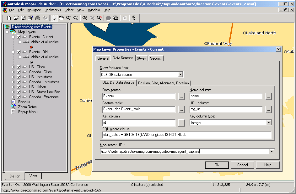
Pulling data from an ODBC source works great, but could be even more powerful.Let's say I want to display a map of sales for the year.If I wanted a layer to display only the sales in January and then a layer with combined sales for June and July I would have to either write a server side program to manipulate the data directly or make a layer and define a SQL string inside MapGuide Author for each query.I would like to see a method for passing an SQL string to the map from within an html file.Yes, I understand that this could be a
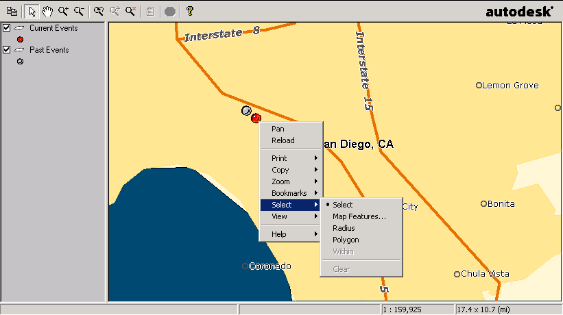
All the data you use in your maps is accessed from the MapGuide Server.You connect to the map server by hostname or IP address using TCP/IP.Therefore you can run the map server on the same machine you author maps on or the map server can be on the other side of the world. With your data now available to many people you need some security features for protection.MapGuide comes through nicely with several methods for securing your data.The first is the ability for the system administrator to create users and groups on the server side.So anyone connecting to your map server using the Author program will need a valid user name and password to access data sources.Also on the server side is a menu for setting permissions on data.On the client side you get protection by password protected files.If someone saves your map file to their computer and opens it they will be prompted for a password.This prevents unauthorized use of or changes to your maps. MapGuide Author is extremely easy to use, even for those with little or no GIS software experience.The manuals are thorough and easy to understand.When I had a problem or question I found the built in help to be very easy to understand and concise; in fact I didn't even have to consult the paper manuals for MapGuide Author.Autodesk is right on the money with an interface that is easy to understand and navigate.If you're coming from any other GIS software you'll feel right at home. Viewing MapsYou've made a great map in the Author program, now how do you let everyone else enjoy it? Its as simple as copying the map file (MWF) over to your web server and pointing users to the URL.Pointing directly to the MWF file is the most direct way for users to view your map.All they need is the correct viewer for their browser.The viewer provides basic functionality such as zoom, pan, info, and search tools.
The other method is to embed the map into an html file.This can be done using the <OBJECT> or <EMBED> tag.With the <OBJECT> tag you can have the ActiveX version of the viewer automatically installed onto Internet Explorer browsers.Here's some example code: <OBJECT ID="Map1" WIDTH=392 HEIGHT=312You'll see that I've defined a parameter that sets the width of the layer pane.There are about 20 other parameters that can be defined either as <PARAM> tags or in the URL query string.If I wanted to set it in the URL query string I would use this bit of HTML: <EMBED SRC="http://http://www.server.com/MapGuide Viewer is also available as a Netscape plug-in and Java Applet.I should also mention that Autodesk has an optional extension to the MapGuide Server called LiteView Extension.This is a Java servlet (runs on the server) that will return a raster image in PNG format.However, none of the regular functions from the plug-in versions such as zoom and pan are supported.I didn't get a chance to play with LiteView, but it does sound interesting for users who need to return only raster versions of their maps. The Server SideBehind the authoring and viewing of maps is the MapGuide Server.It handles requests from the Author and Viewer programs, determines which data to provide, and then returns the data to the clients.The data can come from several sources such as native MapGuide SDF files and a database server like Microsoft SQL.The interface between the web server and MapGuide server is called a MapAgent.There are three different types of MapAgents; ISAPI, NSAPI, and CGI.ISAPI is the best choice if you're using Microsoft Internet Information Server (IIS).NSAPI is used for Netscape Enterprise Servers (now iPlanet).The CGI version works on most other web servers like Apache.Use the native API's if you can because they scale better.Upon installing the server you have the option of selecting which MapAgents you'd like to install.I'm running Microsoft IIS 4.0 so I went with ISAPI version. After installing the MapAgent and MapGuide Server you'll have to do a little bit of setup to get the system ready for MapGuide Author users.You'll need to define
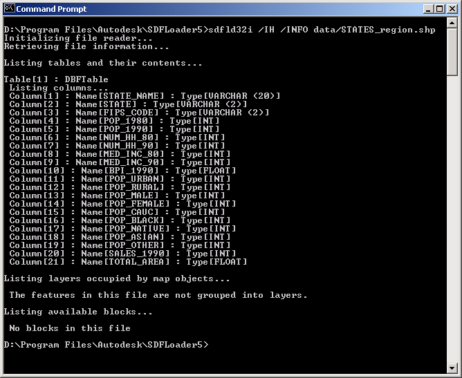
I was fairly disappointed with the sample data Autodesk provided.Luckily we have lots of data lying around here, but not in the native SDF format.Not to worry; MapGuide comes with a nifty data converter called SDF Loader.SDF Loader is a command-line utility that converts data from many different formats into the native SDF format.I set it to work on some ArcView SHP files and the results were impressive.The command-line utility is very fast and easy to use.Sure, it doesn't have all of the fancy drop down boxes and radio buttons of other GIS data converters, but this is not a weakness, it's a benefit.You see, with a command-line utility like SDF loader you can write scripts to automate the task of converting large amounts of data.This is very powerful.
ConclusionWhere does MapGuide fit in relation to other Internet map servers and how does it compare? I found that Autodesk MapGuide has separated itself from other map server software by providing a product that works well within a workgroup or Intranet environment.MapGuide is not meant to be used in a consumer website where casual Internet users would find the nearest dealer.That's not what MapGuide is best at.Instead MapGuide provides an excellent platform for managing large amounts of data centrally and serving it to many users through a standard, easy to use GIS application.Ask yourself these questions.Do you need a map server that is easy to setup, administer and get running out of the box? How about a map server that won't require hiring a group of programmers? Do you need something that even the most green GIS user can use, yet provides enough functionality for more advanced users? If this describes your task, you'll really like what Autodesk has done with MapGuide. Relevant LinksMapGuide MapGuide In Use Web Servers Database Servers |

Saying Farewell to an Amazing Journey
Communicating with Maps
Is There a GIS Career Ladder?
What does it mean to be geospatially smart? Series
Ways Real Estate and Property Developers Utilize Melissa GeoData for Data-Driven Decisions
Unlocking Value From Daily Satellite Imagery and Insights
Maximizing the Value of Your Address Data with Geo Addressing
How Indoor Mapping Enhances the Security of Smart Buildings
Look Ahead: AI, Location Intelligence and Efficiency
Collaboration Takes on Sea Level Rise & Dynamic Technology Environments
Brownies for Brownfields
Has Everything Been Mapped Already?
How Is Data Literacy Changing in an Artificial Intelligence Landscape
Portfolios for GIS Professionals: More Than Just Maps
How to Create a Distance Matrix in QGIS - A Step-by-Step Guide
7 Ideas for Bringing GIS into the K-12 Classroom
The Geography of Movement