GZC, the Slovenian Geodetic Consulting Firm Chooses SuperPad
Supergeo is delighted to announce that the multifunctional mobile GIS software, SuperPad, has been recently selected by the Slovenian geodetic consulting firm, Geodetski zavod Celje, d.o.o. (shortened as GZC) as the tool to collect and processing geospatial data.
Headquartered in Celje, the third largest city in Slovenia, GZC is an international consulting firm, which has dedicated to providing geodetic consulting and technical service for more than a half century. The service area of GZC includes Slovenia and countries in Western Balkans such as Macedonia, Montenegro, and Croatia. And the services provided by them cover from agriculture information system, land management, urban development, cadastral surveying, etc. With professional and experienced workers, GZC is now a well-known and reliable contractor in both Slovenia and the nearby region.
SuperPad is mobile GIS software specially designed for field data collection and is compatible with both Windows and Windows Mobile operating system. Except basic mobile GIS functions, such as spatial data creation, editing, and displaying, it also has powerful online capabilities. SuperPad supports several OGC map services, including WMS, WMTS, and WFS. Therefore, the field workers can access these services straight in the field and save the time spending on preloading data to the mobile devices. And more important, SuperPad can achieve high-precision positioning by the NTRIP extension and professional surveying devices, which is a very helpful feature for land management professionals and geodetic consulting firms.
Watch the overview of SuperPad’s GNSS/GPS functions on YouTube:
https://www.youtube.com/watch?v=Bknjm6vikpY
Get a free trial of SuperPad via:
http://www.supergeotek.com/download_6_mobile.aspx
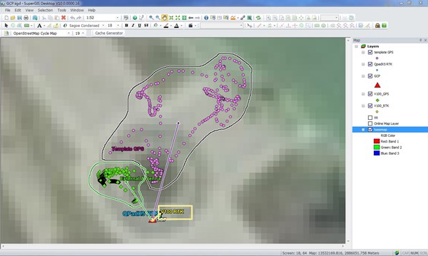
The violet dots are the data collected by normal GPS (3-5m) and the yellow dots (0.5m) are collected by SuperPad with NTRIP extension.