What’s New in the Next SuperGIS Spatial Statistical Analyst
For the most phenomena occurred on this planet, they often have certain patterns in geography. For example, a person who has a cold is more likely to infect his family members and neighbors instead of the people lived in a remote village. Another example is the rainfall observed by a weather station is more possibly the same as the station that is two kilometers away than ten kilometers away. Therefore, when the data is not enough or impossible to access, it is a common way to use spatial statistical skills to estimate the unknown values.
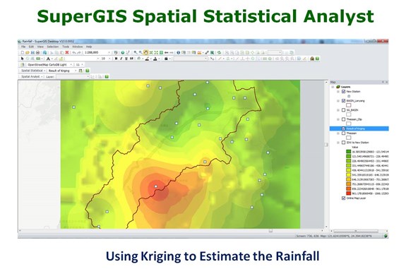
Spatial statistics is a branch of statistics considering more how local factors in geography will influence the result. Some methods of spatial statistics are so complicated to calculate with common statistical software while their indices and parameters also confuse the users very often. As one of the extensions of SuperGIS Desktop, Spatial Statistical Analyst perfectly integrates geostatistical method and geospatial technologies to help advanced GIS users calculate various indices. This extension includes basic statistical functions like scatter plot, regression analysis, and Thiessen polygons and advanced ones like Kriging methods. The integrated and intuitive interface and the Wizard will help users to get the result efficiently with simplified processes.
Before the end of second quarter 2017, Supergeo will release a new version of Spatial Statistical Analyst, which will add new statistical charts like QQ plot. The newly supported charts and graphs will help users identify the distribution pattern, so parameters that are more appropriate can be select for the analysis. For the improvement of Kriging, the interface will be rebuilt in a more user-friendly way, and more instructions and guides will be added to optimize the data exploration. Lastly, there will be several tools for exporting the results and charts, so the users can check them repeatedly and use in different reports.
Check out how to use spatial statistics to estimate the rainfall:
https://www.youtube.com/watch?v=SLzGeQ71RdM
Try out SuperGIS Spatial Statistical Analyst now:
http://www.supergeotek.com/download_6_desktop.aspx