This article brought to you by CoreLogic
Geocoding Accuracy
The need for precision-level geographic information crosses many departments when there is opportunity to build, invest, expand and divest. There is a need for consistent accuracy across the enterprise, whether it is for engineering applications, special tax district assignment, asset management or risk mitigation.
Geocoding converts addresses into geographic coordinates. To provide the most accurate results, CoreLogic® developed a high-precision, parcel and structure-level geocoding and spatial analytics engine. It evaluates multiple datasets, including postal information, street data, parcel boundaries, structure footprints, as well as robust address matching technology and more.
Spatial Analytics
These spatial analytics help companies answer questions such as:
► Which tax jurisdictions are these proposed properties in?
► Where are transmission lines buried in this area and what do they overlap?
► What is the risk of flooding or fire for a specific location or asset?
Parcels and Property Characteristics
Parcel boundaries are the foundational building block to achieve the most granular accuracy in geocoding, allowing companies to take their business into a new dimension of location awareness—for a host of applications. The CoreLogic parcel boundary data set is the most comprehensive and accurate collection in the U.S. With an offering that combines parcels with property characteristics, CoreLogic simplifies land record management.
Municipal and Township Boundaries
CoreLogic maintains a proprietary municipal and township boundary data set validated by local authorities and aligned to real property assets. With a staff dedicated to the ongoing research of tracking changes, our data set is always up-to-date. Our Township Boundary layer contains township-level information for all 50 U.S. states. These township maps consist of contiguous polygonal township or township-equivalent boundaries, and are aligned to our Municipal and County Boundary layers. The municipal and township layers are rigorously maintained to reflect current annexations, de-annexations, and incorporations throughout the nation. The layers can be licensed in Shapefile or Geodatabase format for use within CoreLogic software products or a company’s existing GIS applications.

Geocoding accuracy, combined with parcel-level data, helps companies identify tax jurisdictions, assets and service locations with targeted precision.
Tax Jurisdiction Layers
The accurate determination of taxes is burdensome for accounting departments. If taxes are not correctly assessed and properly remitted, companies can incur negative publicity, as well as costly penalties or other liabilities. CoreLogic tax jurisdiction layers provide access to municipality data as well as enhanced tax data that identifies the lowest-level taxing jurisdiction and remittance data.
Spatial tax data can help businesses determine:
► The lowest-level taxing authority
► The tax remittance authority
► Whether the location is subject to special tax districts
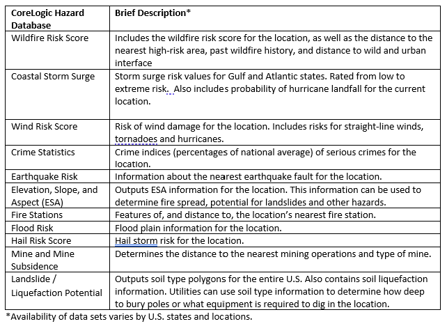
Natural Hazard Risk Layers
Although generic hazard risk data is readily available, the degree of accuracy and usability of this data is suspect, at best. The CoreLogic staff of PH.D.s in geography and natural hazard science[KM1] has developed comprehensive data layers that enable our customers to better analyze and manage risk, and plan for emergency response.
CoreLogic Natural Hazard Risk Layers are modeled at the most detailed level possible, and risk levels are determined by the proximity to a hazard and by the hazard attributes. All hazard risk layers can be integrated into a company’s own GIS applications.
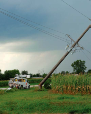
CoreLogic Natural Hazard Risk Layers help operations teams analyze and manage risks and emergencies.
Leverage Location Intelligence to grow your business
A key client of CoreLogic® provides technical expertise and proprietary tools to assist its customers in overcoming the labor intensive and expensive GIS processes related to due diligence and spatial analysis. This client has combined their years of expertise, granular and current location data from CoreLogic® and state-of-the-art geospatial technology to streamline Right of Way processes and provide turnkey solutions for clients in the areas of Public and Private Utilities, including Electricity generation and Public Infrastructure.
Our client explains that the preliminary step in launching projects is determination of land ownership. With data from CoreLogic, they can quickly and accurately identify primary stakeholders for their projects.
As a service industry, speed of service is key and waiting several weeks for access to the content they need is not an option. The competitive advantage of timely, accurate, content means a huge boost in productivity, and the clients end users appreciate the efficient processes accurate results and lack of delays.
CoreLogic has worked closely with this client over the years to develop multiple solutions to automate this step using next generation API deployments and technology transformation tools to insert the needed information directly into various GIS solutions in support of projects. This is a significant advantage over time consuming manual processes that have historically been necessary to standardize and consolidate data that lacks ubiquitous standards across the nation.
Renewable energy projects are highly competitive for developers, and the data discovery that can be done in an afternoon allows our clients end users to quickly advance their projects, mobilize their resources, and get boots on the ground.
“The biggest benefit of our CoreLogic collaboration has been the resulting client satisfaction and therefore the increase in business for us.”
Stakeholders from Utility, Energy, and Telecomm companies can benefit from the unique property-level insights from CoreLogic to assess risk, simplify land record management and improve business performance.
Learn More about how CoreLogic can transform your business.