This article brought to you by Airbus
With the upcoming launch of the second two Pléiades Neo satellites, Airbus has developed the most powerful and accessible commercial remote sensing constellation. While the first two satellites launched in 2021 staked a claim to the highest native spatial resolution and geolocation accuracy, the completed four-satellite constellation kicks off an era of unprecedented responsiveness to customer needs.
Automated end-user tasking and advanced on-orbit data relay technologies, enable Airbus customers to directly schedule image acquisitions as little as 25 minutes before a satellite overpass and receive the image product in as little as two hours after collection. And the offset orbits of four identical satellites in the Pléiades Neo constellation expand daily revisit frequency up to three times daily nearly anywhere on Earth.
After the launch of the first two Pléiades Neo satellites, this near real-time imaging capability will be used for applications relating to unexpected or unplanned events, such as natural disasters. With all four Pléiades Neo satellites – and complemented by Pléiades 1A/1B and SPOT 6/7, Airbus expects to experience a major increase in demand for imagery from frequent or persistent monitoring applications.
Airbus has implemented these direct tasking capabilities for its other commercial imaging satellites as well. Just as they can for Pléiades Neo, customers can place direct tasking orders for the SPOT 6/7 and Pléiades 1A/1B satellites through the Airbus OneAtlas platform. In addition, the OneAtlas API allows for machine-to-machine communication where multiple orders can be placed through a GIS or other software workflow.
A Legacy of EO Advancement
Airbus’ preeminence in commercial Earth observation dates from 1986 when the company (then known as SPOT Image) launched the SPOT 1 satellite with 10-meter spatial resolution in the panchromatic band – unprecedented at the time. In subsequent years, the organization developed successively more advanced Earth observation technologies and satellites, including the still-operational SPOT 6 and 7. Launched in 2012 and 2014, respectively, SPOT 6/7 captures panchromatic imagery at 2m resolution and four-band multispectral (RGB, NIR) at 8 meters.

A look at the resolutions from the Airbus Constellation, ranging from 22m to 30cm.
Concurrent with the SPOT 6/7 development, Airbus jumped into the sub-meter imaging market in a big way with the Pléiades program. The agile Pléiades 1A and 1B satellites were launched in 2011 and 2012 providing remarkable half-meter (50cm) spatial resolution imagery products along with massive data collection capacities and daily revisits. These satellites whet the commercial market’s appetite for even higher resolution imagery, paving the way for the Pléiades Neo program.
Airbus launched the first two satellites in this new constellation, officially referred to as Pléiades Neo 3 and 4, in 2021. These will be followed by Pléiades Neo 5 and 6 launching in the coming weeks. In terms of imaging capabilities, the four satellites are identical. Their 30cm native spatial resolution is the highest available on the commercial market, and their geolocation accuracy is unmatched. The uncorrected imagery has a native planimetric accuracy of 3.5 meters (m) CE90, while the orthorectified products boast a stunning 5m CE90 accuracy.
Additionally, the four Pléiades Neo satellites capture image data with enhanced multispectral capacities including the Deep Blue and Red Edge bands, complementing the Red, Green, Blue and Near Infrared bands. The four Pléiades Neo satellites each collect 30cm panchromatic and 1.2m multispectral image data at 14km swath widths. Each also acquires up to 500,000 square kilometers (km2) per day and up to 7,500 km2 in a single pass. Together, the four will capture 2 million km2 in a single day.
The combination of direct tasking, spatial resolution, geolocation accuracy, new bands, and responsive delivery makes the constellation the most versatile surveying and mapping satellites ever built for commercial use.
A New Era in Direct Tasking
The Airbus OneAtlas portal is now the focal point for direct tasking of Pléiades Neo, Pléiades 1A/1B, and SPOT 6/7 satellites by customers, partners, and resellers on an order-by-order basis. The graphical user interface contains numerous tools to assist customers in scheduling the right data acquisition for their needs. The portal can also be used in searching for archived data sets.

OneAtlas offers the option for customers to directly task satellites with multiple options depending on urgency of acquisition.
The first step in the OneAtlas GUI is defining the area of interest (AOI) in one of several ways – drawing a polygon on the world map, manually inputting location coordinates, entering a geographic name (i.e., city, state or region), or uploading an AOI shapefile. From there, the OneAtlas GUI gives the user three options for the tasking order:
- OneDay – The user specifies a day when the AOI acquisition is desired, perhaps to coincide with a scheduled event. The interface displays all overpasses for that day, including details on the satellite, local time, and incidence angle. The user can then choose the desired acquisition. Orders can be cancelled or postponed up to 12 hours before acquisition if, for example, the weather forecast for that day is unfavorable.
- OneNow – The popular option for imaging unplanned and emergency events, such as natural disasters, this plan lets the user schedule acquisitions immediately and the satellites continue to collect imagery until an image with less than or equal to 10% cloud cover is collected. Collections occur regardless of cloud cover but can be stopped after three collection attempts. Also, a premium price can be paid to limit orders to acceptable weather conditions.
- OnePlan – The most common overall acquisition plan, this allows the user to select a time period within which the desired collection, or multiple collections, will take place. An advantage of this plan is the creation of a Feasibility Study generated by the tasking system to estimate the likelihood of a qualified image being captured, taking into account weather forecasts and other parameters.
The OneDay and OneNow plans offer tasking options that assign a higher satellite priority to the requested acquisition. In terms of general priority, it should be noted that Airbus built the Pléiades Neo system as a dedicated commercial constellation, which means private-sector customers are not competing with government organizations for acquisition scheduling.
The interface then displays all the upcoming satellite overpasses that meet the tasking requirements. The user is informed which satellite will be available with a listing of the spatial resolution and spectral capabilities for each along with the specific time – usually between 10 am and noon local time. From the available options, the user selects the specific acquisition opportunity that best meets their needs.
Once the acquisition has been fully defined, the OneAtlas interface presents Production options for the collected image data. The available processing levels include the following:
- Spectral band combination
- Geometric processing level
- Projection
- Orthorectification DEM reference
- Radiometric processing
- Pixel coding
- Product format
- Production priority
- License
Delivery Options and Order Tracking
The final steps in the process allow the user to review their order and select their delivery preference. Based on the information entered, the tasking interface calculates a price for the user to accept before the acquisition is scheduled. Each constellation has a different minimum and maximum geographic collection area, but the minimum order size is 100 km2.
Delivery preferences include options for both download and streaming. Image products with full metadata can be downloaded from the customer’s MyData workspace in the Google cloud. Or the user can request from numerous standard streaming options, such as WMS, WMTS, and WCS endpoints, or a proprietary WCS-like service called Pixel4Analytics. Orders can also be delivered through an API directly into a geospatial application if the customer has set up a machine-to-machine connection via OneAtlas.
As soon as OneDay and OneNow customers place an order, the acquisition command is sent directly to the satellite during the next upload of tasking commands. As noted, this may occur for Pléiades Neo orders as soon as 25 minutes before overpass depending on the location of the chosen satellite. OnePlan orders are uploaded after the customer sees and approves the feasibility study.
Once the order has been placed, the user can continue to track the acquisition progress through the OneAtlas interface, seeing when collections have or haven’t taken place. OnePlan customers can review images that have been rejected by the system because they failed to meet the acquisition parameters. In some cases, users can agree to accept a rejected image if they view it and find that clouds, for example, do not cover a specific area of interest.
Customers can also set up automatic notifications through OneAtlas to let them know, usually via email, that the data capture has occurred, and their product is ready. As noted, product delivery can take place – even for processed imagery – in as little as two hours after capture by the Pléiades Neo satellites. With even quicker data acquisition and delivery offered by the Space Data Highway, created by Airbus, to relay raw data from the sensor to the ground almost instantly after acquisition, regardless of satellite location, the speed (and weight) of data acquisition and transfer is even faster.
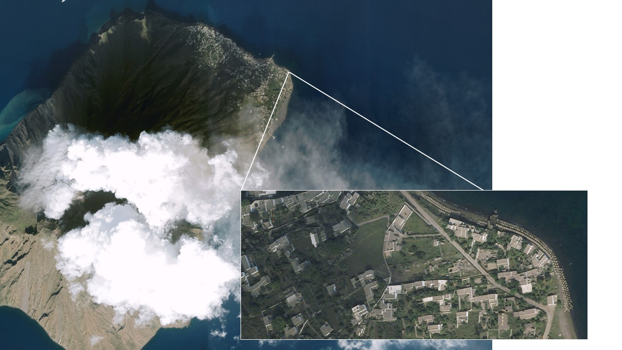
30cm resolution data from Pléiades Neo over the Stromboli Volcano, Italy when it erupted in October 2022.
Airbus is already seeing fast ordering and rapid product turnaround expanding the demand for imagery products. Defense and emergency response organizations are requesting and receiving imagery in the immediate aftermaths of man-made and natural disasters – or while the events are still unfolding – for more effective deployment of resources. Maritime organizations rely on multiple images captured in a short period to identify and track dark vessels at sea.
Airbus expects the combination of very high-resolution imaging and unmatched responsiveness of Pléiades Neo will convert many monitoring organizations into first-time satellite imagery users even if they currently rely on other technologies. Ongoing and frequent imaging of specific locations on intraday, daily, weekly, and monthly cycles will prove a boon to infrastructure security, construction progress assessments, marine port traffic control, and retail site competitive analysis.
To learn more about tasking Pléiades Neo, please visit: https://www.intelligence-airbusds.com/imagery/one-tasking/