Used technologies and products
Bentley software was preferred as a main platform for all GIS and AECO (Architecture, Engineering, Construction, and Operation) projects for the AzersuCIS. Azersu has been using MicroStation PowerDraft v8i as CAD software and putting all infrastructure data into a spatial database with GeoSP@TIAList software. Data can be displayed with Bentley Power Map or other GIS software for advanced analysis and thematic resymbolizations. WaterCAD or SewerCAD products can also easily access AzersuCIS data and make sophisticated design and modeling studies.
Using the ODAKENT GeoSP@TIAList solution provides real-time collaboration to more than 100 Azersu users in disparate locations.
GeoSP@TIAList is an advanced urban infrastructure and environmental management solution based on a geographic information system that provides data security, access to the maps and information for planning, production, operation and emergency management. GeoSP@TIAList is a desktop and web based software running on Bentley Microstation PowerDraft software that uses a PostgreSQL/PostGIS database.
Bentley and Odakent technologies offered very powerful solution to Azersu. Using Bentley’s intelligent infrastructure solution, Azersu utilized the resultant digital asset and operational information platform for ongoing maintenance, operations and compliance activities. Disaster and incident response as well as corrective actions can be addressed with assured information integrity. Proactive lifecycle planning can be undertaken for operational changes such as remodeling, expansion, or repurposing. Ultimately, this resulted in higher quality and better-performing infrastructure assets with improved operational efficiency and safety, reduced time, increased resilience and a greater return on infrastructure investments. Moreover, Information modeling facilitated the creation and integration of design, documentation and analysis in a federated repository for design, operation and construction information. This supported rigorous simulation of an infrastructure asset’s performance so that the project team could explore the implications of options as they worked to maximize design objectives. Working in a context of a unifying 3D modeling environment enabled highly immersive interaction within the design process and ensured the production of trusted deliverables that reflect the latest decisions and changes throughout the project timeline.
2. Properties of used technologies and products :
ODAKENT - GeoSP@TIAList solution offers an alternative approach encompassing:
- Innovation
- Saving money
- Sustainable
- Decreasing costs of operations and planning
- Citizen/Client satisfaction and increasing the competency in field solution of analysis, reporting and business intelligence.
Other properties of ODAKENT - GeoSP@TIAList solution are below :
Open, Flexible, Modular Architecture
GeoSP@TIAList is structured to keep information in an open format in the spatial database and adheres to Open Geospatial Consortium specifications. GeoSP@TIAList is a solution that has water, wastewater, stormwater facilities and address data input and update modules. These interfaces include standard database structures and rule bases for high location sensibility.

Figure 1
Single Data Source
Spatial database technology is at the center of the AzersuCIS project. All vector and attribute information of the infrastructure and superstructure are kept in a spatial database. Therefore, accessing the information faster and more secure without data redundancy is extremely useful.
User Friendly Interface Design
GeoSP@TIAList requires users to register prior to data input. All infrastructure and superstructure data, updates, and reports use a single form. All the maps in the target area can be monitored by a single click with respect to “ClickSee” technology.
Powerful Map Management System
GeoSP@TIAList can archive and manage thousands of maps with different dates and scales. It provides the opportunity to use topographic, orthophoto, satellite maps, cadastral plans etc. as CAD files.

Figure 2 (click for larger image)
Infrastructure Based Data Models, Work Flow and Rules
GeoSP@TIAList provides interfaces to related infrastructures including water, wastewater and storm water networks. The information includes address, property, date and file, and material can be searched using a rule based approach for every data input.
Functional Management Interface
GeoSP@TIAList Administrator Interface has a simple interface useful for people that are not IT professional who can make basic database management function, authorization, reporting and work rules define. Therefore, being a database expert is unnecessary for data production and updating.
Spatial Authorization
Data input and authorization of updates can be given to users based upon a specific county, street or restricted area through the Manager Interface. In the same way, users access can be controlled at the level of infrastructure and superstructure.
High Level Security
The GeoSP@TIAList solution keeps the current information and updates separate and provides an approval mechanism for changes to data. In addition, every update is restricted and changes about the object can be tracked easily. By means of this function, a high level security can be provided for spatial information.
Real 3D Support
Digital Elevation Models (DEM) and orthophotos can be viewed easily by the ClickSee function. Infrastructure and superstructure plants can be draped with facade materials.
Spatial File Management
Related files with the existing infrastructure and superstructure can be attached to the spatial objects. Also they can be stored as database blob object or hyperlink. The files can be reached easily when desired by the querying spatial and different information.
Integrated Web Access
GeoSP@TIAList GeoWeb, is a standard and Integrated part of GeoSP@TIAList CAD/GIS. Nontechnical users or managers can access the map information, reports and analysis results easily with a web interface. All the changes are screened in that interface immediately because AzersuCIS GeoWeb uses the same data source with the CAD/GIS interface.
Powerful Analysis Support
GeoSP@TIAList keeps the topographic information of the infrastructure plants updated. Because the model has been developed previously, network lines are connected with the buildings and the network model is easy to create. When new infrastructures and superstructures are added, topology can be updated automatically.
Address and Client Information System Integration
Client/Citizen information is important especially for local governments and infrastructure companies. OKADENT GeoSP@TIAList solution has an interface that provides the integration among the information in the system, and access to the National Address Database and Client Information System.
As-Built Projects Preparing Tool
One important difference of GeoSP@TIAList from the other GIS solutions is providing a special database file that can be used to prepare as-built information. By means of this tool, as-built project information is prepared as GIS data and transferred to the spatial database directly.
GIS Project Preparing Tool
GeoSP@TIAList has a powerful GIS project preparation tool that can convert CAD data to PostgreSQL PostGIS 2.0 or Oracle 11g Spatial. By means of this tools CAD data can be converted to spatial geometry format fast and accurately.
After implementation of the AzersuCIS project, the following issues have been optimized by using the OKADENT GeoSP@TIAList software:
Standard Document Preparing (Print/Plot):
Customizable and ready to use standard forms are used in Print/Plot works. Users’ names and titles, their managers, date of print etc. attribute data are provided from database and inserted into selected legends automatically. Dynamic scaling is possible according to paper size. North arrow and scale bar are standard objects placed into legend before printing.
In 2012, the project averaged 20 standard documents that were prepared daily as institutional infrastructure documents.
Online Monitoring of Performance, High Level of Security
All AzersuCIS users are registered to database and only registered users can access to system. Since they are logged, it is easy to get answers to the questions such as how many times a user accessed AzersuCIS.
AzersuCIS also has the capability of monitoring data input, update, query processes. Because of being a database application, performance of each user can be monitored. Furthermore, security of the data is at a high level. It’s possible to monitor all user actions like insert, delete and update for any object in the system. This capability is vital for our institution which makes extensive modifications in its system every day.
Superior Querying
When you put all data into AzersuCIS, it is easy to get data that users need. For example, you can obtain the wastewater lines and manholes according to location, manufacturer, material, dimension, construction or date. It provides powerful querying capabilities to users.
Benefits:
In water and wastewater sector, management trend to analyze its investments according to its overviews of service inputs and supply methods to get the goal means using sources effectively and cost reduction.
- What are the assets that we have?
- Where are they?
- Which kind of condition are they in?
- How are their efficiencies?
- What are their values?
- How many subscriber/citizen have they connection with?
- Is the potable water amount the same with the invoiced amount?
- How changes water loss rates among regions?
These kinds of questions are not only needed to set consciousness of saving and cost control, to analyze service processes considering citizen-focused apprehension; but also to make decisions on the strength of knowledge and analysis of resource utilization.
Open, integrated and modular GeoSP@TIAList solution resuced cost and increased productivity because of:
- A dramatically drop in stationary, blueprint, photocopy and transportation cost,
- Fast processing
- A rise in staff productivity
- Decrease in files and information
- Shortening waiting time
- Integration of different settled units and teams
- Fast network in data sharing and use among work units
- Simplifying related policy
- An increase in service users
- An increase in customer satisfaction
Return on Innovation:
AzersuCIS project provided return on investment as given below;
- Dropping costs without compromising the quality and amount of services
- Simplifying overviewed operations and processes and reducing document works
- Preventing expenses and money loss
- Reforms on service processes with improved and applied guidelines
- Shortening bureaucratic processes and simplifying citizen related services
- Considering strategic priorities in investment decisions
Time Saved: 6000 capita/year
Average document processing about answering to requests about existing infrastructure were decreased from 2 hour/document to 25 min/document. Also reaching time of any maps (topoqraphical, satellite, ortophoto etc) decreased from 1 hour to 20 seconds. In the remaining time period, personnel directed to other businesses.
Money Saved: $800,000 USD in 9 months
Cost items such as stationery supplies, blueprint, photocopy, personnel etc. have been decreased considerably. For these departments, which are far from each other, many were suffering from transportation and communication expenses. After implementation of AzersuCIS project, 70-90% of expenses have been saved depending on type of spending.
What technology innovation sets this project apart from others?
The AzersuCIS project and GeoSP@TIAList software have a lot of different innovations. Some of the main innovations of AzersuCIS solution are given below:
- Having Infrastructure and address data input, update, report and analysis modules in one form with the use of integrated management model.
- Address, Customer and other information systems integration.
- User, location and function based authorizations, user performance tracing.
- User based features or maps visibility control.
- Standard Data production interface with Insert/Update/Delete buttons.
- Spatial file management support and spatial query support.
- Geo Messaging with spatial objects.
- Change Detection analysis with raster maps.
- Tracking of all inset/update/delete operations’ history on spatial object basis.
- Batch spatial objects creation from CAD drawings
- Superior maps indexing/registration and map management functionality
- Dynamic real 3D infrastructure and superstructure facilities support
- Seamless GeoWeb integration
- Dynamic labeling and symbology
- Print/Plot Support with special forms
- Profile and Cross-section Support
- Spatial file database integration for AsBuilt projects
- Multiple Projection and Datum Support for spatial objects
- Multi-language support
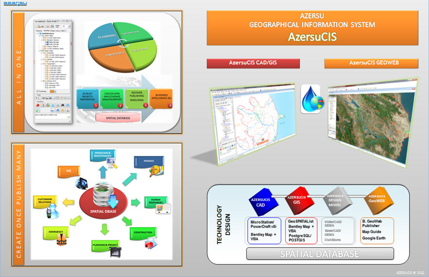
Figure 3 (click for larger image)
Why is this project unique?
In Azerbaijan, there is no institutional GIS project yet. This project is a groundbreaking reference project which is built on top of Bentley and OKADENT spatial database technologies. GIS was first implemented with Bentley products in Azersu. All contractors will prepare as-builts with MicroStation and GeoSP@TIAList.
- This project showed us that CAD and GIS can work together.
- The unique feature of this project is to have an institutional structure. All users of the project must be registered to use the system. Then they may be authorized to see/edit/report each of the maps and spatial features.
- This project has both CAD, GIS and web-based platforms. Interfaces are all user friendly so it is so easy to use or manage of the system.
- Return on investment ratio of this project is so high. Productivity of users has increased visibly.
- This project is unique and it is the biggest PostgreSQL/PostGIS project that works on Bentley MicroStation v8i.
GeoSP@TIAList is also being used for advanced GIS functions; it has a very strong “Integrated City, Infrastructure and Environmental Management” model. This model is an “open, modular, high-secured, integrated, flexible and scalable” model which was developed and tested by a real business experiences over the years.
After the production of geographic data using this GeoSP@TIAList, the institution will benefit in many ways for doing GIS analysis, monitoring and control system projects that can now be implemented quickly.
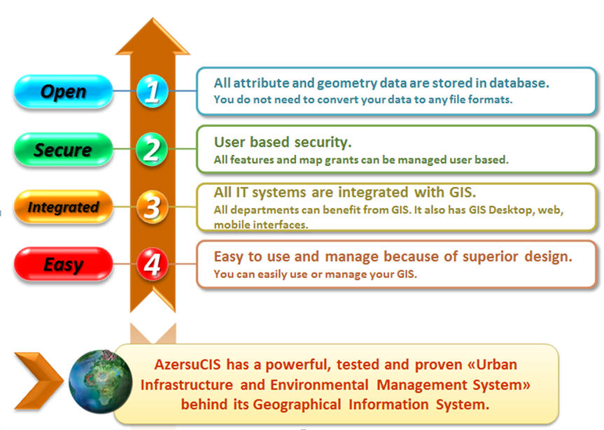
Figure 4 (click for larger image)
Editor's Note: Read Part 1 of this article.
Explore more:
Local, State & Federal Government,
Utilities
From Our Homepage
Saying Farewell to an Amazing Journey
Communicating with Maps
Is There a GIS Career Ladder?
What does it mean to be geospatially smart? Series
Ways Real Estate and Property Developers Utilize Melissa GeoData for Data-Driven Decisions
Unlocking Value From Daily Satellite Imagery and Insights
Maximizing the Value of Your Address Data with Geo Addressing
How Indoor Mapping Enhances the Security of Smart Buildings
Look Ahead: AI, Location Intelligence and Efficiency
Collaboration Takes on Sea Level Rise & Dynamic Technology Environments
Brownies for Brownfields
Has Everything Been Mapped Already?
How Is Data Literacy Changing in an Artificial Intelligence Landscape
Portfolios for GIS Professionals: More Than Just Maps
How to Create a Distance Matrix in QGIS - A Step-by-Step Guide
7 Ideas for Bringing GIS into the K-12 Classroom
The Geography of Movement