Google has announced the expected release of a new platform called Google Earth (GE) Builder. The basics are this:
- GE Builder is a publishing platform.
- GE Builder provides for the ability to move all geospatial data to the cloud for the purposes of map building for end-user consumption.
- GE Builder is intended for enterprise-level data management whereby the most common types of geospatial data (shapefiles, TAB, Mr. SID, JPG2000, TIFF, KML) can be stored and cataloged.
- GE Builder can extract all metadata associated with these data types and index them for quick search.
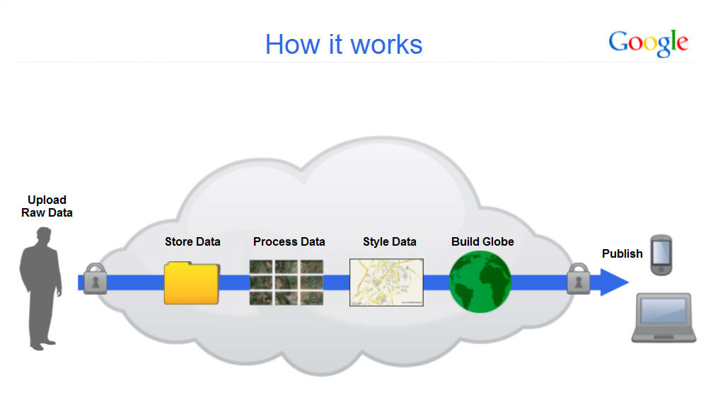 Let's answer some basic questions… these are ones I put to Dylan Lorimar, Google Earth's product manager. I conducted a brief phone interview with him on April 19th. Some of the answers below are paraphrased (refer to graphic at right; click for larger image [Images courtesy of Google]).
If this is a cloud storage platform, how much data can I store?
While pricing is not yet available, it will be based on levels of storage required and provisioned as needed by the user. The platform was conceived with the largest agencies in mind… think petabytes.
What kinds of processing can be performed by GE Builder, if any?
The vision for GE Builder was to productize the processing infrastructure required by large geospatial data sets. For example, if a user wanted to upload raw satellite imagery to the GE Builder cloud, they would be able to process the imagery to perform masking, edge matching, minimal color balancing and "feathering" the tiles to create a seamless image map. By raw, it is presumed you have the data with the appropriate metadata like that found in a GeoTIFF or Mr.SID data. In addition, the tiling of vector data can also be accomplished.
Is vector data supported?
Yes, its supports all manner of vector data and the tools to manage it in the cloud. Users can create and manipulate map layers as well as dynamically style the layers for the creation of a thematic map.
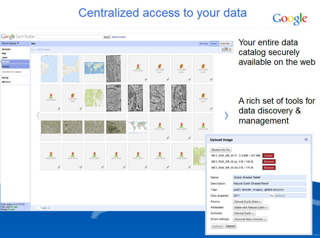
How do you upload data? (refer to image below)
Data is uploaded through the GE Builder catalog interface where the users is allowed to enter a layer name, attribution, tags, source and other metadata.
Does a user need a Google Earth Enterprise license?
Google Earth Enterprise and Google Earth Builder are two separate products. Anyone who has a free Google Earth client can view data published by Builder. Authentication is already built into the Google Earth client. Maps will appear to them in the left-hand panel of the Google Earth client.
Since GE Builder can handle raw satellite image data, can additional image classification or processing be performed as well?
This is not the platform for Google Earth Engine which is a separate project being conducted by Google, but you can envision where this platform is headed.
What else will GE Builder do?
GE Builder is really for two user groups: managing data and then the end users who consume the maps. GE Builder allows users to set map styles (think thematic maps) and publish those directly to end users who will view these data via Google Earth. So, think of this as a way to pre-process geospatial data and then to expose these data to many more viewers.
How does Google envision users will use the product?
Google obviously wants this to be a Platform as a Service (PaaS) model. Users will upload all data to the cloud; store the data in an intuitive data catalog that any user can access from the familiar Google Earth interface. IT administrators no longer need to provision storage and servers with unanticipated spikes in traffic and users get access to data of Google Earth. Benefits accrue to both user and IT manager because all the innovation that Google has worked on for all these years is becoming available to a larger user community … and it’s likely that more of these capabilities in which Google has invested to process geospatial data will continue to be exposed over time … so stay tuned.
 What’s the expected release date?
GE Builder is expected to be released in Q3 2011.
My take: The eye candy we've drooled over for years in Google Earth … which turned into a robust navigation tool for driving directions, points of interest and very cool 3D perspective views of the wildest places on earth, or used solely as a backdrop for other map data via KML … is now a full-fledged enterprise mapping and GIS platform. And truly, the capabilities we've seen so far only scratch the surface of what may be possible in the future. Visualization is there as Google Earth continues to add more geospatial data layers; thematic mapping is there (GE Enterprise and Map API), now cloud storage and basic file and image manipulation are there. If it doesn't already dawn on you, and it should, most of the pieces to construct a fully capable mapping tool are in place and with them the ability to store data in the cloud (and not use internal resources, hard disks, etc.) that makes it very palatable to IT managers. Where this is going is also fairly clear. As Google wishes to expose true image classification (GE Engine) and other investments in map manipulation, more features and functions will be available for map visualization beyond static map views. Google is offering the infrastructure, the platform and the application software services (IaaS, PaaS, SaaS) in a very neat package.
It is, however, still evolving. Pieces are there in chunks and not necessarily intuitive chunks. Workflows need to be streamlined and if you don't have all the pieces from Google, it won't function as a complete enterprise workflow. So, while the APIs are there and now the storage, the typical geospatial technology users need to evaluate these solutions from Google and see if they can understand if the Google workflow is sufficient for their needs. In addition, we don't as yet have the full picture of the pricing model. I expect it to be modest; Google still has to compete with Amazon and others, so we'll see.
What I see emerging is similar to what we found during years of GIS silos. We may still have the Google GIS guy in the backroom working on the APIs for its user community. The question left to be answered is whether the vision that Google has of exposing geospatial data and technology to many more users will, in fact, materialize. We know Google has invested heavily in the consumerization of geodata. Whether that will translate into capturing the investment of the broader geospatial user community is a question yet to be answered.