"Japan is famous for the master designers who harmonized the use of land and structures with the environment around them, finding the right balance between building and nature. Contrast this with the sprawling, monotonous suburbia so familiar today. It's a kind of crime against nature."
Jack Dangermond
When I first met Bill Miller more than 20 years ago, he was talking about design. And he hasn't stopped.
For many years, Miller directed the development of ESRI's training and support infrastructure. Later as an engineer/architect, he was intimately involved in the design of ESRI's state-of-the-art corporate headquarters and conference center. Perhaps his best-known contribution to the GIS community was development of the ModelBuilder environment released as part of the Spatial Analyst extension.
His vision for the integration of geospatial technologies with the design process was long shared by a group of people that included UC Santa Barbara's Michael Goodchild, ESRI President Jack Dangermond, Harvard University's Carl Steinitz, and a handful of others. Miller made this vision "real" when he assembled a small team to develop ArcSketch, a free sample extension that allows you to quickly sketch features in ArcGIS; it was ESRI's first small step toward what is now commonly referred to as GeoDesign.
The sketching concept is key to GeoDesign. "GIS has grown to serve the data and analysis components of workflows quite well, but up until now it has played little role in serving the design component," said Miller. In other words, users of GIS have not been able to do their design work in GIS because GIS did not support that segment of their workflow. "This is now beginning to change." The ability to easily sketch alternative design scenarios and quickly get feedback on suitability by comparing the design proposal to geospatial databases removes the barriers.
Miller retired from ESRI last year, but remains passionate and vocal about the promise of GeoDesign. "GeoDesign lets you use the full power of GIS while you are actually creating your various design proposals," Miller said. "In this way - and this is what I feel is most significant - GeoDesign links design to science and science to design. In short, GeoDesign gives the designer the power to do science-based design."
Is GeoDesign New?
"We've been doing GeoDesign for years" was a statement commonly overheard at the first GeoDesign Summit held in January 2010. "I think GIS, CAD, BIM, neogeography, the GeoWeb, and other concepts are all a part of GeoDesign," said geospatial blogger and WeoGeo evangelist James Fee. "The GeoDesign tools you use depend on the subject matter - NEPA [National Environmental Policy Act] work (gravitates toward GIS), site planning (incorporating CAD or BIM), Web sites and visualization tools (the GeoWeb), or nontraditional geo-sources (neogeography). I think we've all been doing GeoDesign with these tools for years, even decades, but not as a whole concept to implementation practice."
Building on these compartmentalized experiences, GeoDesign formalizes and expands the role of geospatial technologies in design workflows, as well as across the entire lifecycle of a project.
"GeoDesign brings together the NEPA work that leads off projects, the engineering work, feedback from citizens, and its presentation toward all on the Web," said Fee. "In the past what happened was all these disciplines were off doing their own thing and it was up to a project manager to bring them all together. Most of the time this resulted in a document that ended up sitting on a shelf, feedback not being delivered to the groups working on the project, and little collaboration to improve the end results. What GeoDesign does is allow these groups to work together to produce plans and designs that will better interact with the environment around them."
Even with the potential for so much benefit, questions remain about possible overlap between GeoDesign and specific disciplines - and the likelihood that these disciplines will embrace the concept. "GeoDesign and urban planning are probably the same thing," said Atanas Entchev of ENTCHEV GIS Architects. "An urban planner who uses GIS daily to its full potential (I know none) is probably a GeoDesigner. GeoDesign brings a fascinating set of tools to the urban planning profession. But is GeoDesign going to claim some of the planners' territory?"
Definitions Abound
One of the challenges noted by participants at the GeoDesign Summit was that of communication: How could this small group of people best share the vision of GeoDesign with the broader community? To that end, several formal definitions of GeoDesign were proposed at the Summit, and discussion and refinement has continued on Wikipedia and elsewhere. Miller proposed his own, more simple definition:
GeoDesign is the thought process comprising the creation of entities in geographic space.
"I don't think this definition will grab anybody's immediate attention," noted Miller, "but it might help to clarify the power and extent of GeoDesign."
"GeoDesign is both an old idea and a new idea," said Dangermond. "It's timeless." Integrating geospatial technologies into the design process with the goal of living more harmoniously with nature leads to Dangermond's simplified definition:
GeoDesign is designing with nature in mind.
Entchev described GeoDesign in different terms:
GeoDesign is a smart strategic shift from "what is" to "what will be."
Steinitz, whose model of landscape change was highly influential in the development of the GeoDesign concept, stated that "not all geography changes by design, and not all design changes geography." In this context, he proposed what is perhaps the most elegant definition:
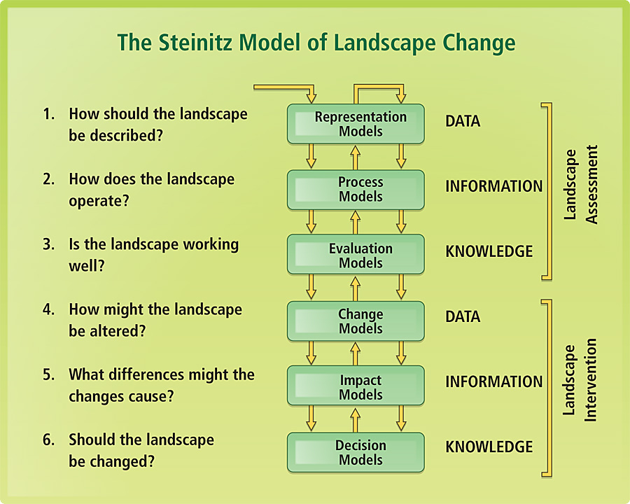
GeoDesign is changing geography by design.
The Future
Although much work remains, the first GeoDesign Summit met its goal of creating a community to advance knowledge and understanding of GeoDesign concepts, technologies and tools. "I'm extremely pleased that so many people are taking an interest in this nascent field and want to be part of its creation," said Miller. "Without this discussion, the idea of GeoDesign would come and go in an instant, leaving us with a huge lost opportunity."
With a concept this powerful - one offering so much hope - the discussion will likely continue for some time. A GeoDesign Idea Lab will be held at the ESRI Developer Summit (March 22-25, 2010 in Palm Springs, California), and a GeoDesign Track is being added to the ESRI International User Conference (July 12-16, 2010 in San Diego, California). In addition, a second GeoDesign Summit is being planned for 05-07 January 2011 in Redlands, California.