Last week the New York State (NYS) GIS Association and
the NYS Office of Cyber Security & Critical Infrastructure
Coordination held the fourth edition of the New York State Geospatial Summit.
I've been privileged to speak at each of these events. This one didn't
have the same energy as the events that preceded it. Previous events
had a "Wow, that's interesting and has nothing to do with what I do"
focus. This year it was more focused on what people actually do, but it
still managed to get people talking and thinking a bit outside their
usual boxes.
Despite the current economic situation, the Summit drew 180 attendees, the second largest crowd in its history. The location, in Schenectady, near Albany, may have helped ease travel for some.
The event is a single-day, all-plenary set of sessions. The morning speakers included Anne Hale Miglarese of Booz Allen Hamilton speaking about the National Geospatial Advisory Committee (NGAC) which she chairs, yours truly speaking on geospatial trends, and former Wyoming Governor Jim Geringer of ESRI who reminded us that "no single map can give you the whole story." After we all spoke, we sat on a panel to answer questions.
Miglarese noted the NGAC is now two years old. While reviewing much of what's been done (detailed at its website which includes many documents state and local government GIS users might find valuable), she shared these key tidbits:
I highlighted three key trends that organizations should study to plan for the future:
Governor Geringer highlighted what he'd learned about using and managing technology in government and reinforced many of Miglarese's ideas about how to "sell" geospatial to politicians. Among his suggestions: put a face on it, separate the technology from the problem to be solved, and speak clearly about what you want from the lawmaker.
The questions and answers afterward targeted the state of the NSDI, the challenges of data as a service if it only provides the latest data (what if you want to run models based on past data?), if emergency managers could be confident depending on data as a service, suggestions to help struggling local government GIS, the "haves" and "have nots" in GIS and more. This group of attendees never seems to be at a loss for questions!
After lunch, the program addressed imagery with presentations from Art Kalinski representing Pictometry, Ron Beck speaking about USGS' "Earth as Art" and Microsoft's Adam Szofran detailing how the Flight Simulator game models the world.
Beck spoke about several USGS efforts to "get the word out" about all the great imagery his agency produces. He highlighted how the Landsat catalog of data is now free to download and shared some interesting stats. In 2007, the USGS sold the highest number of Landsat scenes ever - 7,000. From November 2008 until last Friday some 900,000 scenes were downloaded through the new free online distribution. Beck was quick to note that about 100,000 were downloaded by China, which is building its own archive. Beck is a firm believer that the measure of the value of this imagery is in its use. And, in that spirit, he announced that the Advanced Spaceborne Thermal Emission and Reflection Radiometer (Aster) imagery, which is less than two years old, will be available free for download as of June 1.
In terms of promoting USGS' imagery he pointed to the Earth from Space book by Andrew Johnson and its now touring exhibit. He also pointed to USGS' imagery trading cards for students (can't keep them in stock!, pdf), earthnow.usgs.gov, where you can see the latest data collected by Landsat and finally Earth as Art, a gallery of images from Landsat and Aster. The most downloaded image from that set? The Lena Delta in Russia, which students describe as looking like a brain or a peacock. Beck's theme throughout was: "We need to get students and adults interested, then we can take them further."
Adam Szofran took us on a tour of how Microsoft crams all those "real world looking" data onto two DVDs that make up Flight Simulator. First, Microsoft uses many of the same datasets we professionals do from the likes of NAVTEQ, Jeppeson and NGA. And, it uses the same software many of us do. It uses ESRI technology, though Microsoft uses some custom code, too. The challenge is getting enough high resolution terrain and imagery into the game. How does Microsoft do that? It cheats. Instead of using actual imagery for the whole world, it creates 7,500 "geotypical" tiles for different types of landcover, in different weather and at different times of day. By using some advanced algorithms for image processing, Microsoft can make flying over regions look very much (but not exactly) like the real thing. My favorite part of the presentation was when Szofran showed actual images of locations from Wikipedia, then showed us Flight Simulator's "version" built using these algorithms and tiles. Really impressive!
The good news is that Microsoft is looking for ways to keep Flight Simulator making money in these days of blockbuster games. One option: not selling it in retail stores and instead making it a download with streamed imagery.
Questions for the imagery panel dealt with how to protect data backups if there were some electromagnetic weapon that would destroy digital data, how we can use games like Flight Simulator to encourage student interest in remote sensing and imagery, and the possibilities of using high-end 3D models in games.
I think the difference in the energy this year may have been related to the topics. In past years most of the topics were much "further away" from everyone's day-to-day work, such as modeling Manhattan in the 1800s or getting kids into the outdoors. This year's topics seemed much closer to the problems geospatial practitioners tackle at their desks. And perhaps in these economic times, it's best to stay focused on that work. On the other hand, it doesn't clear the mind in quite the same way as briefly thinking about other challenges.
Despite the current economic situation, the Summit drew 180 attendees, the second largest crowd in its history. The location, in Schenectady, near Albany, may have helped ease travel for some.
The event is a single-day, all-plenary set of sessions. The morning speakers included Anne Hale Miglarese of Booz Allen Hamilton speaking about the National Geospatial Advisory Committee (NGAC) which she chairs, yours truly speaking on geospatial trends, and former Wyoming Governor Jim Geringer of ESRI who reminded us that "no single map can give you the whole story." After we all spoke, we sat on a panel to answer questions.
Miglarese noted the NGAC is now two years old. While reviewing much of what's been done (detailed at its website which includes many documents state and local government GIS users might find valuable), she shared these key tidbits:
- someone created a spreadsheet comparing the various papers put together to encourage support of geospatial in the stimulus bill (I've not heard about, nor seen it)
- those proposals were very similar
- we should look at the broadband group and how its supporters, together, got the $350M for mapping and related efforts
- geospatial has done a poor job on the "so what" and ROI side of making its case
- Vivek Kundra spoke at the recent NGAC meeting; he said (paraphrased): don't ask for money, show me what you did and how it made a difference for citizens
- NGAC will be looking for new members as some step down; a call for new members will be announced in the Federal Register
- geospatial needs a common voice
- geospatial needs to speak to benefits, not educate about technology (as we did in the past)
- NGAC will be hosting public forums; the next one will be at the ESRI User Conference
I highlighted three key trends that organizations should study to plan for the future:
- data as a service
- user generated content
- the new shape of products and packaging
Governor Geringer highlighted what he'd learned about using and managing technology in government and reinforced many of Miglarese's ideas about how to "sell" geospatial to politicians. Among his suggestions: put a face on it, separate the technology from the problem to be solved, and speak clearly about what you want from the lawmaker.
The questions and answers afterward targeted the state of the NSDI, the challenges of data as a service if it only provides the latest data (what if you want to run models based on past data?), if emergency managers could be confident depending on data as a service, suggestions to help struggling local government GIS, the "haves" and "have nots" in GIS and more. This group of attendees never seems to be at a loss for questions!
After lunch, the program addressed imagery with presentations from Art Kalinski representing Pictometry, Ron Beck speaking about USGS' "Earth as Art" and Microsoft's Adam Szofran detailing how the Flight Simulator game models the world.
Beck spoke about several USGS efforts to "get the word out" about all the great imagery his agency produces. He highlighted how the Landsat catalog of data is now free to download and shared some interesting stats. In 2007, the USGS sold the highest number of Landsat scenes ever - 7,000. From November 2008 until last Friday some 900,000 scenes were downloaded through the new free online distribution. Beck was quick to note that about 100,000 were downloaded by China, which is building its own archive. Beck is a firm believer that the measure of the value of this imagery is in its use. And, in that spirit, he announced that the Advanced Spaceborne Thermal Emission and Reflection Radiometer (Aster) imagery, which is less than two years old, will be available free for download as of June 1.
In terms of promoting USGS' imagery he pointed to the Earth from Space book by Andrew Johnson and its now touring exhibit. He also pointed to USGS' imagery trading cards for students (can't keep them in stock!, pdf), earthnow.usgs.gov, where you can see the latest data collected by Landsat and finally Earth as Art, a gallery of images from Landsat and Aster. The most downloaded image from that set? The Lena Delta in Russia, which students describe as looking like a brain or a peacock. Beck's theme throughout was: "We need to get students and adults interested, then we can take them further."
 |
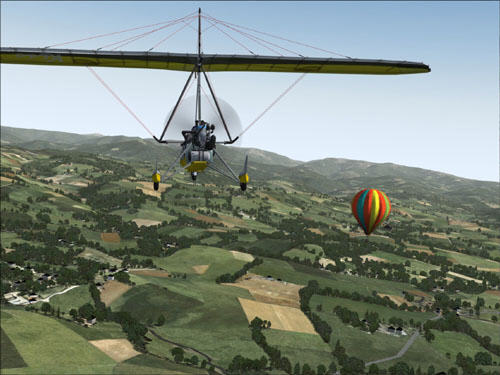
Adam Szofran took us on a tour of how Microsoft crams all those "real world looking" data onto two DVDs that make up Flight Simulator. First, Microsoft uses many of the same datasets we professionals do from the likes of NAVTEQ, Jeppeson and NGA. And, it uses the same software many of us do. It uses ESRI technology, though Microsoft uses some custom code, too. The challenge is getting enough high resolution terrain and imagery into the game. How does Microsoft do that? It cheats. Instead of using actual imagery for the whole world, it creates 7,500 "geotypical" tiles for different types of landcover, in different weather and at different times of day. By using some advanced algorithms for image processing, Microsoft can make flying over regions look very much (but not exactly) like the real thing. My favorite part of the presentation was when Szofran showed actual images of locations from Wikipedia, then showed us Flight Simulator's "version" built using these algorithms and tiles. Really impressive!
 |
The good news is that Microsoft is looking for ways to keep Flight Simulator making money in these days of blockbuster games. One option: not selling it in retail stores and instead making it a download with streamed imagery.
Questions for the imagery panel dealt with how to protect data backups if there were some electromagnetic weapon that would destroy digital data, how we can use games like Flight Simulator to encourage student interest in remote sensing and imagery, and the possibilities of using high-end 3D models in games.
I think the difference in the energy this year may have been related to the topics. In past years most of the topics were much "further away" from everyone's day-to-day work, such as modeling Manhattan in the 1800s or getting kids into the outdoors. This year's topics seemed much closer to the problems geospatial practitioners tackle at their desks. And perhaps in these economic times, it's best to stay focused on that work. On the other hand, it doesn't clear the mind in quite the same way as briefly thinking about other challenges.
From Our Homepage
Saying Farewell to an Amazing Journey
Communicating with Maps
Is There a GIS Career Ladder?
What does it mean to be geospatially smart? Series
Ways Real Estate and Property Developers Utilize Melissa GeoData for Data-Driven Decisions
Unlocking Value From Daily Satellite Imagery and Insights
Maximizing the Value of Your Address Data with Geo Addressing
How Indoor Mapping Enhances the Security of Smart Buildings
Look Ahead: AI, Location Intelligence and Efficiency
Collaboration Takes on Sea Level Rise & Dynamic Technology Environments
Brownies for Brownfields
Has Everything Been Mapped Already?
How Is Data Literacy Changing in an Artificial Intelligence Landscape
Portfolios for GIS Professionals: More Than Just Maps
How to Create a Distance Matrix in QGIS - A Step-by-Step Guide
7 Ideas for Bringing GIS into the K-12 Classroom
The Geography of Movement