"Mashup" is a term that describes"Web 2.0" websites
that join the features of one website to another one. According to
Wikipedia, a mashup is a Web application that combines data (content)
from more than one source into a single integrated tool. An example is
the use of spatial data from Google maps, added to location
information, added to business data, thereby creating a new and
distinct Web service that was not originally provided by any of those
sources.
A mashup web application has three parts:
Mapping Mashups
It all started with a man named Paul Rademacher who took Google maps (which launched in 2005) to the next level when he created www.housingmaps.com, the very first Google maps mashup. To make his hunt for a new house easier, he essentially hacked Google maps, modifying the application to overlay information on houses for sale or rent from Craigslist.com, a popular site for classified advertisements. Google employees were impressed, writing on a company Web page that Rademacher's site"blew our minds right off our shoulders." Since then, online mapping applications have become far more sophisticated. The major players in online mapping have all embraced mashups and now offer APIs (application programming interfaces) that allow developers to integrate online maps with their own websites and data.
APIs
An API is a set of software routines, protocols and tools that provides
a developer with all the building blocks for developing an application
program for a specific platform (environment). An API also provides an
interface that allows a program to communicate with other programs,
running in the same environment. There are many types of APIs:
operating system APIs, application APIs, toolkit APIs and Web APIs.
Google Maps APIs
The Google Maps API is based on a simple set of classes. These classes can be used within a JavaScript container, directly within an HTML page, and linked to a database. All of the functionality of a Google Map is based on this simple premise of an embedded JavaScript object built into a Web page. The interface to the API is straightforward, but the simplicity hides some powerful classes, objects and interfaces that enable it to manipulate the Google Map. By combining this interface with the data you want to display, you can support interactive elements on the Web page without having to reload the page or redisplay portions of the map. The key feature of working with Google Maps APIs is using the longitude and latitude of any feature of the map.
According to Programmable Web, mapping mashups represent about 50% of total developed (submitted) mashups, and Google presents about 46% of those.
The Common Features of the Mapping APIs
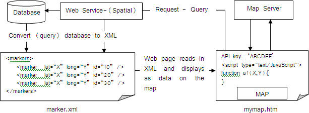
The big three - Google, Yahoo, and Microsoft Virtual Earth - have basically converged, and their map display APIs look more or less alike, implementation details aside. Each offers a way to display a map on a Web page using JavaScript, control the geographic extents and scale of the map, add markers to that map, and trigger various actions based on a flexible user interaction event model. Figure 1 shows the standard data flow in the mapping APIs.
An Example: Calculating the Prayer Times, Distance and Direction to Makkah based on Google Maps APIs
In order to calculate prayer times, three factors must be considered: date, location and methods of calculation. Figure 3 shows the main parameters of the prayer times equation.
The application uses Google Maps to retrieve the longitude and latitude of any selected point on the map, and sends these coordinates to the www.geonames.org Web service to retrieve the basic data of the selected location (location data, time zone data, weather data and elevation data), as shown in figure 4. The location coordinates (longitude and latitude from Google Maps), plus time zone and country name (geonames.org) are used as parameters in the prayer times equations.
Methods and parameters of calculating the prayer times:
1. Muslims have five prayer times each day (Fajr - Dohur - Aser - Maghrab - Isha); the time the sun rises also needs to be calculated.
2. Prayer times are calculated based on (four Muslims Mazhabs): Almazhab AlSHAFI-Al Malki- AlHanbali. Almazhab AlHanafi not considered.
3. The world is classified into five regions in the equations:
For example, to calculate the Fajr prayer time, we use the following equation:
TF = ACOS ((SIN(-18)-SIN(ASIN(SIN(23.439-0.0000004*D)*SIN(L +1.915*SIN(M)+0.02*SIN(2*M)))*SIN(Lat))/(COS(ASIN(SIN(23.439-0.0000004*D)
*SIN(L+1.915*SIN(M)+0.02*SIN(2*M)))*COS(Lat)))
Where,
D = ((367*Y)-(INT((7/4)*(Y+INT((M+9)/12))))+INT(275*(M/9))+d-730531.5)
M = 357.528+0.9856003*D
5. Distance and direction to Makkah Almokarama are calculated based on Haversine formula.
The formula states: For two points on a sphere (of radius R) with latitudes φ1 and φ2, latitude separation Δφ = φ1 − φ2, and longitude separation Δλ, where angles are in radians, the distance d between the two points (along a great circle of the sphere; see spherical distance) is related to their locations by the formula:

Google Maps APIs Resources
Google API Documentation
Working with Google maps
Articles and Tutorials on Google maps
Google Maps Mania
Google Mashup Editor, Google
Programmable Web (Keeping you up to date with mashups)
A mashup web application has three parts:
- A Web page that provides a new service using its own data and data from other sources (from additional content providers)
- An additional content provider that makes data available across the Web through an API and using different Web protocols
- The user of the mashup, who often uses a Web browser to display the Web page containing the mashup
Mapping Mashups
It all started with a man named Paul Rademacher who took Google maps (which launched in 2005) to the next level when he created www.housingmaps.com, the very first Google maps mashup. To make his hunt for a new house easier, he essentially hacked Google maps, modifying the application to overlay information on houses for sale or rent from Craigslist.com, a popular site for classified advertisements. Google employees were impressed, writing on a company Web page that Rademacher's site"blew our minds right off our shoulders." Since then, online mapping applications have become far more sophisticated. The major players in online mapping have all embraced mashups and now offer APIs (application programming interfaces) that allow developers to integrate online maps with their own websites and data.
APIs
 |
Google Maps APIs
The Google Maps API is based on a simple set of classes. These classes can be used within a JavaScript container, directly within an HTML page, and linked to a database. All of the functionality of a Google Map is based on this simple premise of an embedded JavaScript object built into a Web page. The interface to the API is straightforward, but the simplicity hides some powerful classes, objects and interfaces that enable it to manipulate the Google Map. By combining this interface with the data you want to display, you can support interactive elements on the Web page without having to reload the page or redisplay portions of the map. The key feature of working with Google Maps APIs is using the longitude and latitude of any feature of the map.
According to Programmable Web, mapping mashups represent about 50% of total developed (submitted) mashups, and Google presents about 46% of those.
The Common Features of the Mapping APIs
The big three - Google, Yahoo, and Microsoft Virtual Earth - have basically converged, and their map display APIs look more or less alike, implementation details aside. Each offers a way to display a map on a Web page using JavaScript, control the geographic extents and scale of the map, add markers to that map, and trigger various actions based on a flexible user interaction event model. Figure 1 shows the standard data flow in the mapping APIs.
 |
An Example: Calculating the Prayer Times, Distance and Direction to Makkah based on Google Maps APIs
In order to calculate prayer times, three factors must be considered: date, location and methods of calculation. Figure 3 shows the main parameters of the prayer times equation.
The application uses Google Maps to retrieve the longitude and latitude of any selected point on the map, and sends these coordinates to the www.geonames.org Web service to retrieve the basic data of the selected location (location data, time zone data, weather data and elevation data), as shown in figure 4. The location coordinates (longitude and latitude from Google Maps), plus time zone and country name (geonames.org) are used as parameters in the prayer times equations.
 |
Methods and parameters of calculating the prayer times:
1. Muslims have five prayer times each day (Fajr - Dohur - Aser - Maghrab - Isha); the time the sun rises also needs to be calculated.
2. Prayer times are calculated based on (four Muslims Mazhabs): Almazhab AlSHAFI-Al Malki- AlHanbali. Almazhab AlHanafi not considered.
3. The world is classified into five regions in the equations:
4. Prayer times equations are calculated based on Astronomical Algorithms by Jean Meeus.
- Gulf Countries (Saudi Arabia-Qatar-Kuwait-UAE-Bahrain-Oman-Yemen) are based on OM-ALQURA (Makkah Almokarama) calendar.
- USA and Canada are based on Islamic Union of North America.
- Egypt is based on Egyptian General Survey Authority.
- Pakistan is based on Islamic University of Science Karachi.
- The other countries are based on Muslim World League.
For example, to calculate the Fajr prayer time, we use the following equation:
TF = ACOS ((SIN(-18)-SIN(ASIN(SIN(23.439-0.0000004*D)*SIN(L +1.915*SIN(M)+0.02*SIN(2*M)))*SIN(Lat))/(COS(ASIN(SIN(23.439-0.0000004*D)
*SIN(L+1.915*SIN(M)+0.02*SIN(2*M)))*COS(Lat)))
Where,
D = ((367*Y)-(INT((7/4)*(Y+INT((M+9)/12))))+INT(275*(M/9))+d-730531.5)
M = 357.528+0.9856003*D
5. Distance and direction to Makkah Almokarama are calculated based on Haversine formula.
The formula states: For two points on a sphere (of radius R) with latitudes φ1 and φ2, latitude separation Δφ = φ1 − φ2, and longitude separation Δλ, where angles are in radians, the distance d between the two points (along a great circle of the sphere; see spherical distance) is related to their locations by the formula:
 |
Google API Documentation
Working with Google maps
Articles and Tutorials on Google maps
Google Maps Mania
Google Mashup Editor, Google
Programmable Web (Keeping you up to date with mashups)
From Our Homepage
Saying Farewell to an Amazing Journey
Communicating with Maps
Is There a GIS Career Ladder?
What does it mean to be geospatially smart? Series
Ways Real Estate and Property Developers Utilize Melissa GeoData for Data-Driven Decisions
Unlocking Value From Daily Satellite Imagery and Insights
Maximizing the Value of Your Address Data with Geo Addressing
How Indoor Mapping Enhances the Security of Smart Buildings
Look Ahead: AI, Location Intelligence and Efficiency
Collaboration Takes on Sea Level Rise & Dynamic Technology Environments
Brownies for Brownfields
Has Everything Been Mapped Already?
How Is Data Literacy Changing in an Artificial Intelligence Landscape
Portfolios for GIS Professionals: More Than Just Maps
How to Create a Distance Matrix in QGIS - A Step-by-Step Guide
7 Ideas for Bringing GIS into the K-12 Classroom
The Geography of Movement