The Portland
Police Bureau (Portland, Oregon) has been involved with geospatial
analytics for about 17 years. Christy Khalifa, a Portland police crime
analyst, has worked with the program for about two and a half years,
though the Bureau has had geospatial tools for much longer. "We're
pretty progressive as far as getting into new technology," she said.
Indeed. The Bureau's Strategic Services Division, of which she is a
member, developed, along with the Bureau of Technology Services, a
public-facing Web-based CrimeMapper
application that gets about 1.8
million hits a year. It's the second most popular service offered on
the city's Portland Online
site. The purpose of the application is to answer the public's
questions about the safety of specific neighborhoods and the types of
crimes that occur there.
"I love being able to put information like that out to the public because you can put so much information at their fingertips," explained Khalifa. It's fairly common for police departments to make this information available to the public, but not many offer information in a form as interactive as Portland's application, explained Khalifa. I played with the site and was impressed by how many different options and ways to look at data were available to public citizens. (A state-by-state listing of jurisdictions involved in "Crime Mapping" is available at the National Institute of Justice's site.)
Khalifa's background is in criminology and criminal justice, not GIS, and she admitted that some of the terminology still makes her a little nervous. Nevertheless, she's been successful with the Bureau's Arc-based product installation and the applications the GIS group at the Bureau created on top of it. The City of Portland has a GIS team that assisted them with set-up. Khalifa, two other analysts at the Bureau, and four analysts who work in individual precincts have become highly proficient with the tools.
As a graduate student, Khalifa attended neighborhood police meetings as part of the Portland State University's criminology program. There she saw the maps "in action." Now, when she trains officers in the use of the maps and the data access her group provides, they are less interested in the actual training because they want to dive right into the data and start analyzing.
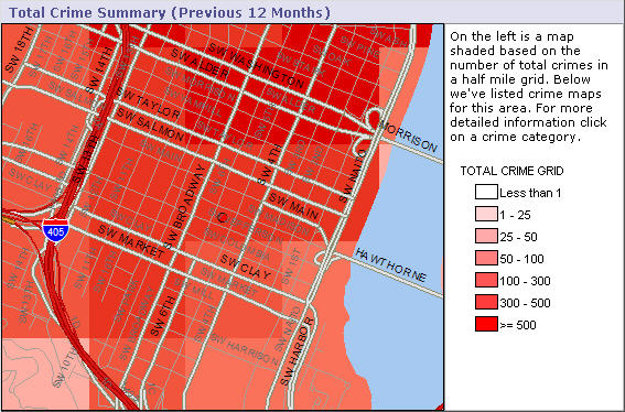
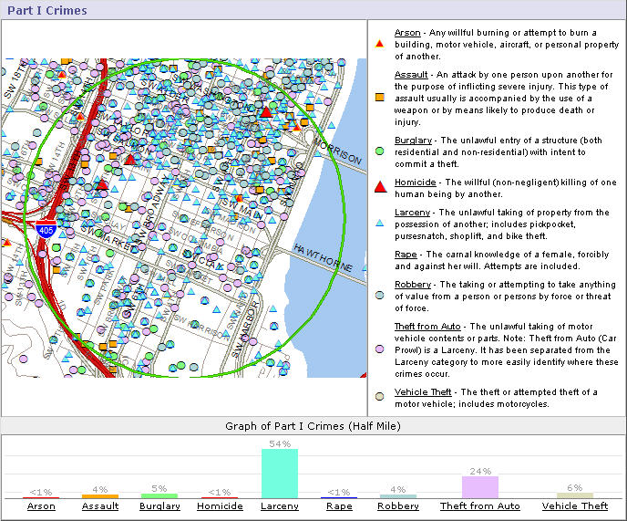
The Crime Analysis Mapping Information Network (CAMIN) is the key application for crime analysts. The CAMIN application allows the analysts to access data on calls for service, arrests and offenses, etc. CrimeMapper is one of these applications. Another is CrimeStats, launched in December 2007, which is a neighborhood-based application for precinct officers and the public. CrimeStats aggregates crime statistics by neighborhoods, crime fighting coalition areas, precincts or larger city areas. The new Freeway Mapping Project allows analysis of calls for service along freeways, but because there aren't addresses along freeways, special geocoding was required. Standard mile markers were used, the coordinates for which were imported from the Oregon Department of Transportation database. The Bureau collected coordinates for half-mile points and for "landmarks" such as on and off ramps.
One analyst put together a series of PDFs that map a 1,000 foot buffer around every school's tax parcel (i.e. "legal") boundary. Crimes within these areas have enhanced penalties, and it's helpful to have maps available that quickly and easily show that zone.
According to Khalifa, there is no staff resistance to using the spatial
crime analysis tools. She said the next big push for the Bureau is to
make Internet access available in squad cars. Once that happens, she
expects that police officers' use of the tools will grow significantly,
as they'll be able to explore maps and data between calls.
In 2006, Khalifa's unit received a commendation award from Portland's mayor and chief of police. She recalled it as a proud moment. "We were approached by an arson investigator," she explained. "He gave us the address, time and dates of the arsons, and asked for a map to brief the people working the case. We made the map, and we also predicted where the next arson was going to happen. They caught this person starting a fire in a dumpster." The unit also provides maps, using the CAMIN application, for detectives who need them for juries. It is very helpful for members of a jury to be able to see the crime patterns, Khalifa said. She has gotten quite a bit of feedback about how successful her group has been in helping to win cases, which is icing on the cake of a job that offers a lot of satisfaction.
"I love being able to put information like that out to the public because you can put so much information at their fingertips," explained Khalifa. It's fairly common for police departments to make this information available to the public, but not many offer information in a form as interactive as Portland's application, explained Khalifa. I played with the site and was impressed by how many different options and ways to look at data were available to public citizens. (A state-by-state listing of jurisdictions involved in "Crime Mapping" is available at the National Institute of Justice's site.)
 |
 |
Khalifa's background is in criminology and criminal justice, not GIS, and she admitted that some of the terminology still makes her a little nervous. Nevertheless, she's been successful with the Bureau's Arc-based product installation and the applications the GIS group at the Bureau created on top of it. The City of Portland has a GIS team that assisted them with set-up. Khalifa, two other analysts at the Bureau, and four analysts who work in individual precincts have become highly proficient with the tools.
As a graduate student, Khalifa attended neighborhood police meetings as part of the Portland State University's criminology program. There she saw the maps "in action." Now, when she trains officers in the use of the maps and the data access her group provides, they are less interested in the actual training because they want to dive right into the data and start analyzing.
The Crime Analysis Mapping Information Network (CAMIN) is the key application for crime analysts. The CAMIN application allows the analysts to access data on calls for service, arrests and offenses, etc. CrimeMapper is one of these applications. Another is CrimeStats, launched in December 2007, which is a neighborhood-based application for precinct officers and the public. CrimeStats aggregates crime statistics by neighborhoods, crime fighting coalition areas, precincts or larger city areas. The new Freeway Mapping Project allows analysis of calls for service along freeways, but because there aren't addresses along freeways, special geocoding was required. Standard mile markers were used, the coordinates for which were imported from the Oregon Department of Transportation database. The Bureau collected coordinates for half-mile points and for "landmarks" such as on and off ramps.
One analyst put together a series of PDFs that map a 1,000 foot buffer around every school's tax parcel (i.e. "legal") boundary. Crimes within these areas have enhanced penalties, and it's helpful to have maps available that quickly and easily show that zone.
 |
In 2006, Khalifa's unit received a commendation award from Portland's mayor and chief of police. She recalled it as a proud moment. "We were approached by an arson investigator," she explained. "He gave us the address, time and dates of the arsons, and asked for a map to brief the people working the case. We made the map, and we also predicted where the next arson was going to happen. They caught this person starting a fire in a dumpster." The unit also provides maps, using the CAMIN application, for detectives who need them for juries. It is very helpful for members of a jury to be able to see the crime patterns, Khalifa said. She has gotten quite a bit of feedback about how successful her group has been in helping to win cases, which is icing on the cake of a job that offers a lot of satisfaction.
From Our Homepage
Saying Farewell to an Amazing Journey
Communicating with Maps
Is There a GIS Career Ladder?
What does it mean to be geospatially smart? Series
Ways Real Estate and Property Developers Utilize Melissa GeoData for Data-Driven Decisions
Unlocking Value From Daily Satellite Imagery and Insights
Maximizing the Value of Your Address Data with Geo Addressing
How Indoor Mapping Enhances the Security of Smart Buildings
Look Ahead: AI, Location Intelligence and Efficiency
Collaboration Takes on Sea Level Rise & Dynamic Technology Environments
Brownies for Brownfields
Has Everything Been Mapped Already?
How Is Data Literacy Changing in an Artificial Intelligence Landscape
Portfolios for GIS Professionals: More Than Just Maps
How to Create a Distance Matrix in QGIS - A Step-by-Step Guide
7 Ideas for Bringing GIS into the K-12 Classroom
The Geography of Movement