 |
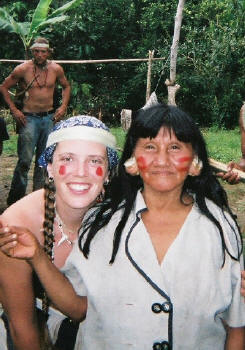
Despite these threats, the people of Quehueriono village maintain the positive attitude that they will be able to successfully petition the Ecuadorian government to close a portion of their land off to oil concessions. With a wide smile, Amo told his guests that the community felt more confident now about approaching the government because they had a powerful tool. When he disappeared into the forest to bring his surprise, his friends talked about their expectations of the Huaorani's new resource: a jaguar skin, a new blowgun, or perhaps more evidence of the impact of oil extraction on his people. Amo returned from the house, however, with a long tube cradled in his arms. His guests watched in surprise as he delicately removed a rolled paper from the tube and, with the careful help of other warriors, held it down flat on the table.
Here, deep in the Amazon, was a map with community input of the Huaorani territory within the Yasuni National Park, oil concessions within the Amazon, and a highlighted area that Amo's community wished to close off to oil extraction. Also included were areas for hunting, firewood, tourism and conservation that the community had designated. The map was generated by community members on transect walks using a GPS in conjunction with the USAID 'Caiman' project, EcoCiencia, TROPIC, and the Instituto Geografico Militar. As the guests watched, the warriors at the table traced the yellow lines of the oil blocks with their fingers to demonstrate how their community was truly surrounded on all sides.
 |
The Huaorani's story demonstrates the power of community mapping and why Participatory Geographic Information Systems (PGIS) are diffusing so rapidly. PGIS is the merging of participatory development with various geospatial technologies and has its origins within academia, development agencies and activist communities. PGIS thus contains a broad spectrum of practices, but each has in common the combination of local knowledge and formal "expert" information to produce an integrated geospatial database that addresses community concerns. Of course, communities are socially differentiated, and do not necessarily have homogenous aspirations. As a result, PGIS displays many spatial perspectives and produces outcomes ranging from community produced sketch maps to Web-based multimedia spatial decision making systems.
Within the academy, PGIS emerged out of a broadly defined GIS and Society debate. There is now an annual URISA conference that brings academics and community development practitioner/planners together. PGISs in core industrialized countries are increasingly Web-based GIS projects that extend to communities. In developing regions, PGIS tends to be more firmly rooted in practices of participatory development and its increased utilization of geospatial technologies. This intersection is producing a paradigm shift in development practice as evidenced in the recent Mapping for Change International Conference on Participatory Spatial Information Management and Communication.
The conference was held at the Kenya College of Communication Technology in September 2005. Attending the conference were 154 people from 45 different countries, there to support the belief that PGIS can ultimately "encourage positive social change" (Corbett et al, 2006). The major themes of the conference included networking, the creation of PGIS resource centers and defining good practices. Working groups were also able to collaborate on issues such as:
- policies and funding that can either "enable or disable" PGIS projects
- building solidarity and a common vision among PGIS practitioners
- sharing PGIS experiences such as the representation of local spatial knowledge, ethics of the practice, and ideas on how to protect cultural heritage
- regional strategies for supporting PGIS practice
In certain cases, more than one tool of PGIS practice must be used, either together or in sequence, to address specific community spatial concerns. For example, the Kayapo people of Brazil accessed both satellite imagery and GPS to make maps of their traditional land use management areas. In this case, the PGIS practice was important as a political tool for the Kayapo to demonstrate territorial unity (Moikarako, 2006). In another case study in the Caprivi Region of Namibia, Taylor et al (2006) shared the potential for PGIS practice to expose and address issues of "identity, rights and land." The authors shared their experiences with PGIS practice for strengthening local rights and increasing the community's capacity to manage a conservation area.
The experiences and ideas that were generated from the Mapping for Change Conference extended beyond the conference participants. Contributions were made to the United Nations Educational, Scientific and Cultural Organization (UNESCO) declaration about cultural mapping that helped lead to UNESCO identifying cultural mapping as an important tool and methodology for protecting cultural diversity. In addition, in April 2006, 30 states ratified the UNESCO Convention for the Safeguarding of Intangible Cultural Heritage which both supported the inventory of cultural heritage and raised questions about the ethics of the practice (Rambaldi, 2006).
The need for good PGIS practice was another important product of the Nairobi conference. As PGIS is inherently multidisciplinary, it should incorporate a number of different moral and ethical guidelines. For example, participants agreed that the foundations of the 'three T's' must be added to the traditional components of mapmaking. These are: "transparency, time and trust" (Corbett et al, 2006). The authors state that transparency is needed in all interactions, and time and patience are required to build the trust that is necessary between the practitioner and the community. In a paper developed from conversations and ideas resulting from the conference, Rambaldi et al (2006) state that practice of PGIS is "scattered with critical stepping stones all calling attention to troubling dilemmas and overarching issues about empowerment, ownership and potential exploitation." In response to these problems, the authors outlined a "guide to good practice" to help practitioners make appropriate ethical choices. Since maps and their representations are such potentially powerful products, the emphasis on good practice and ethics can be the difference between community empowerment and further marginalization.
There is an undeniable excitement within both practitioner and participant communities about the potential for PGIS to be used as an agent for positive change. For example, for the last fifty years of Huaorani history, the Queheuriono community has had reason to associate foreigners with threats to their land and their culture. Amo and his family believe that his people are now fighting for their cultural survival. Yet instead of retreating deeper into the Amazon, they have determined to use the best means available to protect their land. Their decision to use PGIS at this crucial moment in their history is a strong testament to the potential of advanced geospatial technologies to empower communities to protect their land, their culture, and gain a voice in local natural resource management. The choice of communities across the world, as evident in the Nairobi conference, to reach for a resource that is the combination of participatory methods and geospatial technologies may also signify a profound paradigm shift in development planning and practice.
References
Corbett, J., G. Rambaldi, P. Kyem, D. Weiner, R. Olson, J. Muchemi, M. McCall and R. Chambers. (2006). "Overview: Mapping for change – the emergence of a new practice." IIED, Special Issue on "Mapping for Change: Practice, Technologies and Communication." Participatory Learning and Action, 54: 1-13, London.
Corbett, J. and P. Keller. (2006). "Using community information systems to express traditional knowledge embedded in the landscape." IIED, Special Issue on "Mapping for Change: Practice, Technologies and Communication." Participatory Learning and Action, 54: 21-28, London.
Craig, W., Harris, T., and D. Weiner (eds.) (2002). Community Participation and Geographic Information Systems. London: Taylor and Francis.
Jardinet, S. (2006). "Capacity development and PGIS for land demarcation: innovations from Nicaragua." IIED, Special Issue on "Mapping for Change: Practice, Technologies and Communication." Participatory Learning and Action, 54: 67-74. London.
Khem, P. (2006). "Finding Common Ground in land use conflicts using PGIS: lessons from Ghana. IIED, Special Issue on "Mapping for Change: Practice, Technologies and Communication." Participatory Learning and Action, 54: 36-41, London.
Minang, P. and M. McCall. (2006). "Participatory GIS and local knowledge enhancement for community carbon forestry planning: an example from Cameroon." IIED, Special Issue on "Mapping for Change: Practice, Technologies and Communication." Participatory Learning and Action, 54: 85-93, London.
Moikarako, inhabitants of, P. de Robert, J. Faure, and A. Laques. (2006). "The power of maps: cartography with indigenous people in the Brazilian Amazon." IIED, Special Issue on "Mapping for Change: Practice, Technologies and Communication." Participatory Learning and Action, 54: 74-79. London.
Rambaldi, G., Kwaku Kyem, P.; McCall P. and D. Weiner. (2006). "Participatory Spatial Information Management and Communication in Developing Countries." Electronic Journal of Information Systems in Developing Countries, 25 (paper # 1):1-9.
Rambaldi, G., S. Tuivanuavou, P. Namata, P. Vanualailai, S. Rupeni, and E. Rupeni. (2006). "Resource use, development planning, and safeguarding intangible cultural heritage: lessons from Fiji islands." IIED, Special Issue on "Mapping for Change: Practice, Technologies and Communication." Participatory Learning and Action, 54: 28-36. London.
Taylor, J., C. Murphy, S. Mayes, E. Mwilma, N. Nuulimba, and S. Slater-Jones. (2006). "Land and natural resource mapping by San communities and NGOs: experiences from Namibia." IIED, Special Issue on "Mapping for Change: Practice, Technologies and Communication." Participatory Learning and Action, 54: 79-85. London.
Weiner, D. and T. Harris, 2003. "Community-Integrated GIS for Land Reform in South Africa." URISA Journal. 15(2): 61-73.
From Our Homepage
Saying Farewell to an Amazing Journey
Communicating with Maps
Is There a GIS Career Ladder?
What does it mean to be geospatially smart? Series
Ways Real Estate and Property Developers Utilize Melissa GeoData for Data-Driven Decisions
Unlocking Value From Daily Satellite Imagery and Insights
Maximizing the Value of Your Address Data with Geo Addressing
How Indoor Mapping Enhances the Security of Smart Buildings
Look Ahead: AI, Location Intelligence and Efficiency
Collaboration Takes on Sea Level Rise & Dynamic Technology Environments
Brownies for Brownfields
Has Everything Been Mapped Already?
How Is Data Literacy Changing in an Artificial Intelligence Landscape
Portfolios for GIS Professionals: More Than Just Maps
How to Create a Distance Matrix in QGIS - A Step-by-Step Guide
7 Ideas for Bringing GIS into the K-12 Classroom
The Geography of Movement