I have always been amazed at how a variety of tools
designed for unrelated tasks can work together to create something new,
the sum of which is greater than their individual components. It
is more than synergy; it is achievement of an elegant solution or
application.
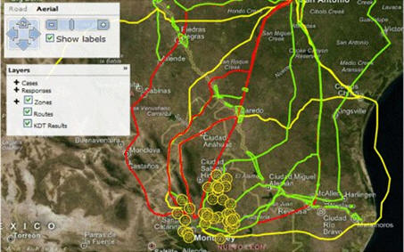
At the GEOINT Symposium I saw the folks from Thetus, the knowledge modeling company (company, article). They took me to the Accenture booth to show me an application created using a variety of tools, including Thetus software, an Oracle database and a combination of hardware, software and firmware from Exegy that does very fast database extraction. Accenture had functioned as a systems integrator.
The application looks at a hypothetical scenario for a virus crossing a small section of the US/Mexico border along a number of routes identified on a map. The map acts as the central point of access to the application. Some of the routes are easy and direct, some are moderately difficult and some are difficult. While this initially looks like another typical GIS application using maps and imagery, the difference is that the data are accessed, processed and updated in near real-time. The outcome of potential actions that might be taken to mitigate the spread of the virus could be analyzed at almost the same rate that the data are acquired and processed.
The impact of hypothetical impedances inserted into various routes
could be modeled, and the results seen immediately. In the example,
real and modeled resources work seamlessly (as do the combined
applications) to assess and predict interception or mitigation of the
potential virus.
All of the variables (resources, events or actions) can be collected as a set of icons on the map. In the image above, the icons appear as boxes or circles that can be dragged by the user's finger onto a specific part of the map. This is useful because it allows the user to focus on the problem at hand rather than on how to make the application run. Training consists of learning what the resources are, what the icons represent and how to move them. It's just that simple, and expertise is acquired in minutes.
When you look at the workflow through the various parts of this application, it is the scope of it that is really interesting. Thetus manages the entire workflow.
The entire system is scalable, due to the "industrial strength" nature of its components. Multiple field sensors feed the system, along with other sources, imagery, HumINT. The scope of the problem addressed could involve an area the size of the entire US/Mexico border or another equally challenging arena.
If you use your imagination, this solution could be applied in the world of business, allowing you to make informed business decisions in real-time, thus enabling you to stay way ahead of your competition. It could portray sales from a promotion or product introduction. Then, because the system is probably fast enough, product/promotion tuning might be done on the fly. Things like optimal product mix could be modeled, explored, implemented and reviewed/revised at a rate not currently possible. How cool would that be?
At the GEOINT Symposium I saw the folks from Thetus, the knowledge modeling company (company, article). They took me to the Accenture booth to show me an application created using a variety of tools, including Thetus software, an Oracle database and a combination of hardware, software and firmware from Exegy that does very fast database extraction. Accenture had functioned as a systems integrator.
The application looks at a hypothetical scenario for a virus crossing a small section of the US/Mexico border along a number of routes identified on a map. The map acts as the central point of access to the application. Some of the routes are easy and direct, some are moderately difficult and some are difficult. While this initially looks like another typical GIS application using maps and imagery, the difference is that the data are accessed, processed and updated in near real-time. The outcome of potential actions that might be taken to mitigate the spread of the virus could be analyzed at almost the same rate that the data are acquired and processed.
 |
 |
All of the variables (resources, events or actions) can be collected as a set of icons on the map. In the image above, the icons appear as boxes or circles that can be dragged by the user's finger onto a specific part of the map. This is useful because it allows the user to focus on the problem at hand rather than on how to make the application run. Training consists of learning what the resources are, what the icons represent and how to move them. It's just that simple, and expertise is acquired in minutes.
When you look at the workflow through the various parts of this application, it is the scope of it that is really interesting. Thetus manages the entire workflow.
- The data are all stored in Oracle.
- As data are acquired they are processed automatically using the Thetus workflow engine. Data are conditioned and routed to the appropriate analytics tools, such as MetaCarta for geo-location or Attensity for fact extraction. Thetus tracks the data lineage with a detailed history of all the changes and processing events critical to the "What if…?” and "When did we learn this?” questions.
- Exegy does data and text mining from the database. Exegy's products sustain extraction rates for both text and data mining of up to 5GB/second, which is important in emergency situations. This means they can read, search, analyze, filter, cache and transform at 5GB/second.
- Thetus also enables the dynamic knowledge modeling and discovery functionality, providing the means to predict and assess what's happening from information that has been received, stored, extracted and geo-positioned. In addition, Thetus provides the "what ifs” as requested by the user. This is a fusion of spatial and non-spatial data providing the means to access, interpret and act on the data - on the fly, in near real-time.
The entire system is scalable, due to the "industrial strength" nature of its components. Multiple field sensors feed the system, along with other sources, imagery, HumINT. The scope of the problem addressed could involve an area the size of the entire US/Mexico border or another equally challenging arena.
If you use your imagination, this solution could be applied in the world of business, allowing you to make informed business decisions in real-time, thus enabling you to stay way ahead of your competition. It could portray sales from a promotion or product introduction. Then, because the system is probably fast enough, product/promotion tuning might be done on the fly. Things like optimal product mix could be modeled, explored, implemented and reviewed/revised at a rate not currently possible. How cool would that be?
From Our Homepage
Saying Farewell to an Amazing Journey
Communicating with Maps
Is There a GIS Career Ladder?
What does it mean to be geospatially smart? Series
Ways Real Estate and Property Developers Utilize Melissa GeoData for Data-Driven Decisions
Unlocking Value From Daily Satellite Imagery and Insights
Maximizing the Value of Your Address Data with Geo Addressing
How Indoor Mapping Enhances the Security of Smart Buildings
Look Ahead: AI, Location Intelligence and Efficiency
Collaboration Takes on Sea Level Rise & Dynamic Technology Environments
Brownies for Brownfields
Has Everything Been Mapped Already?
How Is Data Literacy Changing in an Artificial Intelligence Landscape
Portfolios for GIS Professionals: More Than Just Maps
How to Create a Distance Matrix in QGIS - A Step-by-Step Guide
7 Ideas for Bringing GIS into the K-12 Classroom
The Geography of Movement