Geomatica 10 is an extensive suite of geospatial
applications and tools offered by Canadian-based PCI Geomatics.
Geomatica 10 is an image-centric application that brings together
remote sensing, GIS, cartography and photogrammetry into an integrated
environment. The software is born out of the precepts of the science
and technology behind geomatics, a discipline concerned with
collecting, storing, processing, and distributing geographic
information. In this review I will attempt to give insight into the
program’s usability, capability and performance, and the opportunities
for training and support.
Prior to installing and reviewing Geomatica 10, I used the freely available data viewing tool Geomatica FreeView which is available at the PCI website. The viewer can reportedly open more than 100 raster and vector formats and is offered powerful viewer features including image enhancement and attribute table viewing. I manage several labs and find the tool very useful in visual identification and browsing of network stored data volumes. The program is actually an extract of the larger program Geomatica 10 and I highly recommend its use as a general purpose geospatial browser.
System Requirements and Installation
The software arrived with an installation CD, five data CDs, a 26 page manual, a hardware key and a license string. According to the manual, the program supports Windows 2000/XP, Sun Solaris 8/9/10, SGI IRIX 6.5.23, and Linux RedHat Enterprise Workstation 4, Linux SUSE 9.3, and Open Motif 2.2.2. I elected to install this program on my two primary computers, an Intel Pentium 4 2.8GHz desktop and an Intel T2500 2.0 GHz Core Duo notebook, both with 1 GB of RAM each and running Windows XP Professional OS. The system PCI recommends is a Pentium 3 600 MHz or later with 512 MB of RAM, but most users would probably get the performance they are looking for at higher processor speeds and at least 1 GB of RAM.
The quality of your graphics card and monitor should also be an important consideration in running an image-centric application like Geomatica 10. The Windows absolute minimum is a 16-bit graphics card or accelerator that can run at 1,024 x 768 pixels which meets the OpenGL standard. Again, if you are going to invest in this software you will want to run it on a computer with optimum speed and performance in both processing data and rendering images. Therefore I would recommend using a graphics card designed for image processing and a monitor large enough and preferably wide enough to display your images and panels without overlap.
The installation of Geomatica 10 was very simple and processed quickly on both the notebook and desktop. License managers can be a bit cumbersome with many proprietary software packages but this was not the case with Geomatica. My particular install did, however, require the use of a USB dongle. These are not exactly conducive to mobile use because they can be easily lost or broken while on the go. As with any package, be sure to check with PCI on how your license will be managed and updated.
In the performance comparison between the notebook and desktop computers, the notebook outperformed the desktop. Throughout the evaluation process I experienced almost no glitches or extended wait times on the notebook, whereas the desktop configurations had just a few hangs and only one crash during my testing. Overall in the Microsoft Windows XP environment and within the described hardware configuration it was my general impression that the software is very stable and responsive. However, it should be noted that the software was not specifically designed to make use of dual-processors to run a single Geomatica process, but such a configuration should allow you to run another computer application while processing without considerable performance loss.
Usability
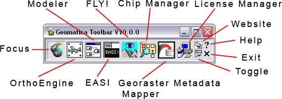
The array of applications and tools are first presented in a desktop toolbar (figure 1) that you can toggle between horizontal and vertical positions. Unfortunately, it does not appear that you are able to move, remove or add features to this toolbar which limits its capability. A feature that seems unnecessary to access frequently, for example, is the license manager. Although the toolbar may initially seem a good way to introduce the user to the multiple functions of the program, an improvement would be to make it an obvious integration within the main data visualization environment in the program called Focus.
With smaller icons the toolbar could be more compact, thereby keeping
it out of the way for those with limited screen real estate. After all,
the workspace and images should be the primary and central focus of the
screen view. Perhaps it would make more sense to have the toolbar open
and default to a marginal area of the screen. Most users will probably
find the main Focus toolbar more useful and customizable in accessing
functions and tools.
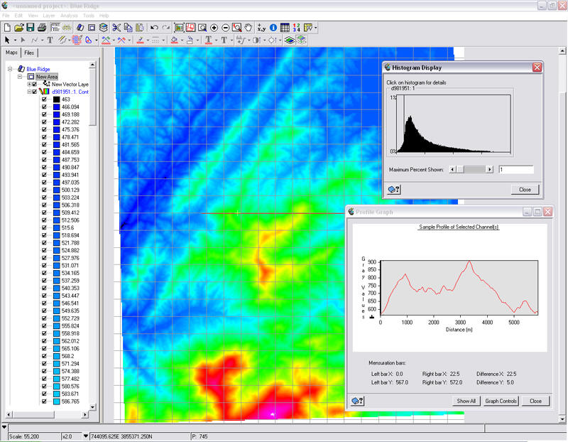
The graphical user interface of Geomatica 10 (figure 2) is very functional and the tabbed legend frame makes switching on and off layers and views very easy. Both characteristics and functions can also be accessed with ease from this legend frame. In fact, the entire interface is both intuitive and unobtrusive compared with similar programs. A proposed enhancement to this interface could be dockable panels that could display algorithm or other libraries, image characteristics like histograms, or frequently used complex tools. Highly flexible and customizable user interfaces are certainly growing in demand, and while Geomatica 10 could use a few tweaks, it does appear PCI is progressive in making usability enhancements.
Capability and Performance
One of the most impressive capabilities of Geomatica 10 is its ability to view or assimilate so many different file formats. Simple panning and zooming is often a task taken for granted in other programs. In displaying high resolution imagery with very large file sizes, good response times are essential. In both the desktop and laptop configurations Geomatica 10 performed flawlessly when using PCI’s proprietary PCIDSK format. The PCIDSK file format is useful in bringing together multi-source information about your coverage area, making it easier for you to manipulate your data for analysis and keep things organized.
With comprehensive software packages, users rarely use all the available features. Therefore, repetitive tasks and their specific functions should be easily initiated. A particularly useful feature in this package is the Focus Algorithm Librarian, and key to its usefulness is that users are able to define their own algorithm categories, thereby giving them quick and easy access to their “favorites.”
Another obvious improvement to the program is the componentization of functions which can reportedly be linked together into automated workflows and run in batch processes. Production workflow efficiency can also be boosted through sets of geospatial tasks that include automated orthorectification, mosaicking, DEM extraction, feature extraction and change detection, all of which can be embedded within existing processes. Further, users have a choice of approach to these tasks, either through visual modeling or command-line scripting.
During my review, I discussed Geomatica’s capability with another researcher who had used the software extensively to analyze landscape changes over time. The researcher had collected ground control points in the field and then used them to georeference the various sets of imagery which were draped over DEMs. ‘Fly-throughs’ were then created of the subject area using the FLY! Tool, allowing visualization of the subject area at different time periods. The output ‘fly-through’ movie was impressive and streamed smoothly and without any notable artifacts.
In my own tryout of features, I created a color shaded relief model. Even as a new user to the program I was able to quickly grasp the methods needed to perform the process. The map and file trees of Focus make it possible for you to stay oriented within your workflow as you perform both the image editing and modeling functions. If you have many models to generate from edited PCT files, there is the Modeler alternative method in which you can obtain a script from PCI’s script exchange webpage.
In another tryout I worked through mosaicking non-georeferenced imagery. On several occasions I have come across the need to “stitch” oblique images or create panoramic views. In Geomatica you can create mosaicked images through OrthoEngine using the Polynomial Math Model. You can do this with jpeg images, but PCI suggests that you import them into the PIX format. By geocoding the image with ground control points you can sequentially step through matching points within the images. There are several non-geospatial programs on the market that can automate most of the processes involved with merging images. However, by manipulating the images manually you have more control over final output quality as long as you have quality source images when you begin.
Training and Support
Training opportunities for the new Geomatica user can be rather limited but according to PCI Geomatics both their commercial and educational licensing packages do include training manuals and sample data for licensed users. After filling out a short online form you can download an evaluation version, download demo movies, or book a live demo. From the website you can find a few downloadable tutorials in Adobe PDF format without submitting your information, but the tutorials do seem to lack depth.
At the time of this review, all of the 2006 instructor-led course offerings were available at the main training facilities in Canada, at Gatineau, Quebec or the University of Calgary. For current users, PCI offers a two day course that covers the new features of Geomatica 10, and there is certainly enough material to fill a week for both beginning and intermediate users. For organizations that can afford it, there is an option for customized training on-site.
As PCI flexes Geomatica to be more a comprehensive software package by integrating its applications in remote sensing, GIS, cartography and photogrammetry, there need to be resources and a proper venue to support users from novice to expert. Complements to the Geomatica suite could include freely available introductory training materials and scenario examples, detailed application-specific tutorials, and perhaps a limited student version. More importantly, PCI should consider upgrading their email discussion thread to a better organized community forum. The geospatial community could learn from other software development companies that have benefited by giving an opportunity to allow users to support one another through the use of well-organized and moderated forums. Such a venue would help users quickly find the information they need, strengthen the Geomatica user community, and help PCI assess customer needs in planning future versions.
Concluding Comment
Perhaps a more in-depth review of the software package’s capability could hash out more specific improvement possibilities for this impressive program. Having moved from a professional environment to an educational environment, I recognize a need to leverage the software to not only enhance usability but to reduce the learning curve for both the current and next generation users. It is apparent that PCI is an industry leader in developing a truly integrated geospatial platform. In this latest release of Geomatica, PCI appears to have adequately met the need of enterprise.
Prior to installing and reviewing Geomatica 10, I used the freely available data viewing tool Geomatica FreeView which is available at the PCI website. The viewer can reportedly open more than 100 raster and vector formats and is offered powerful viewer features including image enhancement and attribute table viewing. I manage several labs and find the tool very useful in visual identification and browsing of network stored data volumes. The program is actually an extract of the larger program Geomatica 10 and I highly recommend its use as a general purpose geospatial browser.
System Requirements and Installation
The software arrived with an installation CD, five data CDs, a 26 page manual, a hardware key and a license string. According to the manual, the program supports Windows 2000/XP, Sun Solaris 8/9/10, SGI IRIX 6.5.23, and Linux RedHat Enterprise Workstation 4, Linux SUSE 9.3, and Open Motif 2.2.2. I elected to install this program on my two primary computers, an Intel Pentium 4 2.8GHz desktop and an Intel T2500 2.0 GHz Core Duo notebook, both with 1 GB of RAM each and running Windows XP Professional OS. The system PCI recommends is a Pentium 3 600 MHz or later with 512 MB of RAM, but most users would probably get the performance they are looking for at higher processor speeds and at least 1 GB of RAM.
The quality of your graphics card and monitor should also be an important consideration in running an image-centric application like Geomatica 10. The Windows absolute minimum is a 16-bit graphics card or accelerator that can run at 1,024 x 768 pixels which meets the OpenGL standard. Again, if you are going to invest in this software you will want to run it on a computer with optimum speed and performance in both processing data and rendering images. Therefore I would recommend using a graphics card designed for image processing and a monitor large enough and preferably wide enough to display your images and panels without overlap.
The installation of Geomatica 10 was very simple and processed quickly on both the notebook and desktop. License managers can be a bit cumbersome with many proprietary software packages but this was not the case with Geomatica. My particular install did, however, require the use of a USB dongle. These are not exactly conducive to mobile use because they can be easily lost or broken while on the go. As with any package, be sure to check with PCI on how your license will be managed and updated.
In the performance comparison between the notebook and desktop computers, the notebook outperformed the desktop. Throughout the evaluation process I experienced almost no glitches or extended wait times on the notebook, whereas the desktop configurations had just a few hangs and only one crash during my testing. Overall in the Microsoft Windows XP environment and within the described hardware configuration it was my general impression that the software is very stable and responsive. However, it should be noted that the software was not specifically designed to make use of dual-processors to run a single Geomatica process, but such a configuration should allow you to run another computer application while processing without considerable performance loss.
Usability
The array of applications and tools are first presented in a desktop toolbar (figure 1) that you can toggle between horizontal and vertical positions. Unfortunately, it does not appear that you are able to move, remove or add features to this toolbar which limits its capability. A feature that seems unnecessary to access frequently, for example, is the license manager. Although the toolbar may initially seem a good way to introduce the user to the multiple functions of the program, an improvement would be to make it an obvious integration within the main data visualization environment in the program called Focus.
 |
The graphical user interface of Geomatica 10 (figure 2) is very functional and the tabbed legend frame makes switching on and off layers and views very easy. Both characteristics and functions can also be accessed with ease from this legend frame. In fact, the entire interface is both intuitive and unobtrusive compared with similar programs. A proposed enhancement to this interface could be dockable panels that could display algorithm or other libraries, image characteristics like histograms, or frequently used complex tools. Highly flexible and customizable user interfaces are certainly growing in demand, and while Geomatica 10 could use a few tweaks, it does appear PCI is progressive in making usability enhancements.
 |
One of the most impressive capabilities of Geomatica 10 is its ability to view or assimilate so many different file formats. Simple panning and zooming is often a task taken for granted in other programs. In displaying high resolution imagery with very large file sizes, good response times are essential. In both the desktop and laptop configurations Geomatica 10 performed flawlessly when using PCI’s proprietary PCIDSK format. The PCIDSK file format is useful in bringing together multi-source information about your coverage area, making it easier for you to manipulate your data for analysis and keep things organized.
With comprehensive software packages, users rarely use all the available features. Therefore, repetitive tasks and their specific functions should be easily initiated. A particularly useful feature in this package is the Focus Algorithm Librarian, and key to its usefulness is that users are able to define their own algorithm categories, thereby giving them quick and easy access to their “favorites.”
Another obvious improvement to the program is the componentization of functions which can reportedly be linked together into automated workflows and run in batch processes. Production workflow efficiency can also be boosted through sets of geospatial tasks that include automated orthorectification, mosaicking, DEM extraction, feature extraction and change detection, all of which can be embedded within existing processes. Further, users have a choice of approach to these tasks, either through visual modeling or command-line scripting.
During my review, I discussed Geomatica’s capability with another researcher who had used the software extensively to analyze landscape changes over time. The researcher had collected ground control points in the field and then used them to georeference the various sets of imagery which were draped over DEMs. ‘Fly-throughs’ were then created of the subject area using the FLY! Tool, allowing visualization of the subject area at different time periods. The output ‘fly-through’ movie was impressive and streamed smoothly and without any notable artifacts.
In my own tryout of features, I created a color shaded relief model. Even as a new user to the program I was able to quickly grasp the methods needed to perform the process. The map and file trees of Focus make it possible for you to stay oriented within your workflow as you perform both the image editing and modeling functions. If you have many models to generate from edited PCT files, there is the Modeler alternative method in which you can obtain a script from PCI’s script exchange webpage.
In another tryout I worked through mosaicking non-georeferenced imagery. On several occasions I have come across the need to “stitch” oblique images or create panoramic views. In Geomatica you can create mosaicked images through OrthoEngine using the Polynomial Math Model. You can do this with jpeg images, but PCI suggests that you import them into the PIX format. By geocoding the image with ground control points you can sequentially step through matching points within the images. There are several non-geospatial programs on the market that can automate most of the processes involved with merging images. However, by manipulating the images manually you have more control over final output quality as long as you have quality source images when you begin.
Training and Support
Training opportunities for the new Geomatica user can be rather limited but according to PCI Geomatics both their commercial and educational licensing packages do include training manuals and sample data for licensed users. After filling out a short online form you can download an evaluation version, download demo movies, or book a live demo. From the website you can find a few downloadable tutorials in Adobe PDF format without submitting your information, but the tutorials do seem to lack depth.
At the time of this review, all of the 2006 instructor-led course offerings were available at the main training facilities in Canada, at Gatineau, Quebec or the University of Calgary. For current users, PCI offers a two day course that covers the new features of Geomatica 10, and there is certainly enough material to fill a week for both beginning and intermediate users. For organizations that can afford it, there is an option for customized training on-site.
As PCI flexes Geomatica to be more a comprehensive software package by integrating its applications in remote sensing, GIS, cartography and photogrammetry, there need to be resources and a proper venue to support users from novice to expert. Complements to the Geomatica suite could include freely available introductory training materials and scenario examples, detailed application-specific tutorials, and perhaps a limited student version. More importantly, PCI should consider upgrading their email discussion thread to a better organized community forum. The geospatial community could learn from other software development companies that have benefited by giving an opportunity to allow users to support one another through the use of well-organized and moderated forums. Such a venue would help users quickly find the information they need, strengthen the Geomatica user community, and help PCI assess customer needs in planning future versions.
Concluding Comment
Perhaps a more in-depth review of the software package’s capability could hash out more specific improvement possibilities for this impressive program. Having moved from a professional environment to an educational environment, I recognize a need to leverage the software to not only enhance usability but to reduce the learning curve for both the current and next generation users. It is apparent that PCI is an industry leader in developing a truly integrated geospatial platform. In this latest release of Geomatica, PCI appears to have adequately met the need of enterprise.
From Our Homepage
Saying Farewell to an Amazing Journey
Communicating with Maps
Is There a GIS Career Ladder?
What does it mean to be geospatially smart? Series
Ways Real Estate and Property Developers Utilize Melissa GeoData for Data-Driven Decisions
Unlocking Value From Daily Satellite Imagery and Insights
Maximizing the Value of Your Address Data with Geo Addressing
How Indoor Mapping Enhances the Security of Smart Buildings
Look Ahead: AI, Location Intelligence and Efficiency
Collaboration Takes on Sea Level Rise & Dynamic Technology Environments
Brownies for Brownfields
Has Everything Been Mapped Already?
How Is Data Literacy Changing in an Artificial Intelligence Landscape
Portfolios for GIS Professionals: More Than Just Maps
How to Create a Distance Matrix in QGIS - A Step-by-Step Guide
7 Ideas for Bringing GIS into the K-12 Classroom
The Geography of Movement