Introduction
In the future, many computer applications will be inherently mobile, and rely on seamless wireless networking.Although the desktop computer will still exist and be used for many tasks, the majority of tomorrow's computer applications will be accessed on other devices.The integration between telecommunication and data communication will contribute to the creation of a global networking infrastructure that is seamlessly available anytime, anywhere, and through a multitude of different devices.Given the assumption that this global network will soon be available, application designers will find that a number of properties of mobile computer use are unique for this setting, and constitute very different requirements on design and implementation than those have been established for stationary applications.I have helped develop a wireless GIS for many cities in the Kingdom of Saudi Arabia, and in this article I will share some observations based on that experience.
Mobile Mapping Applications Properties
The requirements for mobile applications are very different from stationary applications.There is a need for a general and coherent design approach that addresses properties unique to mobile applications.These properties are summarized as follows.
The term "Mobile GIS" can be defined as an integrated software/hardware framework for the access of spatial data and services through mobile devices via wireline or wireless networks."Wireless GIS" is a subcategory of mobile GIS technology that focuses on the wireless networking capability of mobile GIS services.There are two major application areas of mobile GIS.
The architecture of mobile GIS is very similar to that of Internet-based GIS, using a client-server architecture.Client-server applications usually implement what is referred as a Three Tiered Architecture.This architecture divides the application into a presentation tier, a business logic tier and a data management tier. Each tier can be replaced or updated without affecting the others.
The presentation tier consists of client side components which are used to send requests to the server and to view the results (maps and data). The business tier is the core of any solution and consists of the server side components including the Web server and application server. The data management tier is responsible for the management of both spatial and attribute data in the application.In some cases, one server is used for both the business and data management tier.In other cases each tier can be on a separate server.
LBS Application Opportunities
Applications that use LBS are limited only by developer's imagination, but there are some categories where needs opportunities have been clearly identified.
LBS is anywhere, anytime mobile computing.In practice, it represents the merger of four technologies: Personal Digital Assistants (PDAs) and 3G (3rd generation) mobile phones; location acquisition (automatic or manual); wireless Internet technology and infrastructure; and GIS solutions for wireless (data and application).The last three are discussed further below.
Location Acquisition
For applications to become location-aware, the wireless network must trace the location of the wireless device.This can be done either automatically or manually.Automatic location acquisition uses a positioning network to locate a device using technologies such as GPS or cellular base stations.
Each of these automatic positioning technologies has its advantages and disadvantages.Cellular base stations are ubiquitous across most urbanized areas, but their positioning is not precise enough to accurately locate a user (accuracy within tens to hundreds of meters). In contrast, GPS can be extremely precise (accuracy within meters), but in some cases the signal is obscured inside buildings and in areas with high traffic, narrow streets and high rise buildings.
Applications can be designed to enable quick manual inputs for location acquistion.These include using landmarks, stored locations or addresses and Zip codes.
Wireless Communication Network
Mobile communication is set to be one of the key technologies of the 21st century.Mobile phones have not only gained currency and acceptance worldwide, but did so with a speed that outstrips many other technical innovations at any point in history.Mobile devices satisfy a fundamental human need for communication and independence.The future of mobile communications lies in the extensive interaction of eyes and ears, mobile convenience at any time and in any place, in a way that is more natural than has ever been possible up until now.This can only be implemented on the basis of reliable and forward-looking transmission technologies.They form the foundation for progress in the world of communication.
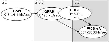
As shown in Figure 1, one of the key 3G technologies is GPRS (General Packet Radio Services).It is an "always on" communication service that transfers information in the same way that Internet does by breaking data up into 'packets' that each follow their own, shortest available route to their destination, where they are reassembled at the receiving end.GPRS currently supports an average data rate of 115 kb/sec, but this speed is only achieved by dedicating all eight time slots to GPRS (the GPRS maximum theoretical data rate under perfect radio conditions is 171 kb/sec).For example, a GPRS device might be set to handle a maximum of four slots downstream and two slots upstream.Under good radio conditions, this yields speed of approximately 50 kb/sec downstream and 20 kb/sec upstream.This is more than three times faster than current (9.6-14.4kb/sec) GSM networks and roughly equivalent to a landline modem connection.
EDGE (Enhanced Data rates for Global Evolution) is a 3G wireless technology that is capable of handling high-speed data.EDGE occasionally is called "E-GPRS" because it is an enhancement of the GPRS network.EDGE cannot be deployed by itself, it must be added to an existing GPRS network.EDGE's real world data rates are far lower than its theoretical peaks of 473 kb/sec.Users can expect average rates of 75-110 kb/sec.
WCDMA (Wideband Code Division Multiple Access) is a high speed 3G mobile technology adopted as a standard by the International Telecommunications Union.WCDMA can reach speeds from 384kb/sec to 2Mb/sec, which represents from 6 to 35 times more than what regular landline modems can do.
Development of Wireless GIS
When we are developing wireless GIS applications running on Pocket PC devices, we need to consider three elements: presentation, browser features and bandwidth.We can summarize the technical characteristics of each element.
Screen size limitations (presentation). The full screen size on a Pocket PC is 240 x 320 pixels.The usable content area in Microsoft Pocket Internet Explorer is 229 x 255 pixels.Sticking to these limitations saves the user from horizontal scrolling.Based on those dimensions, the map console is about 160 x 200 pixel.Another consideration is the Pocket PC built-in keyboard.When activated, it consumes 240 x 81 pixels of screen space.When embedding input forms, we must be sure that the form fields fit the screen width and test that the form is not obscured by the keyboard.
Browser features.The Pocket Internet Explorer (pIE) included with Pocket PC 2003 is, in many way, a considerable upgrade compared to previous versions.Here are a few of those upgrades.The pIE on Pocket PC 2003 supports HTML 4.01 and most pIE support a subset of the HTML 3.2 standards.The Microsoft JScript 5.5 support is now up to the same level as in Microsoft Internet 5.5, which means that most scripts written for desktop applications will be able to run on Pocket PC 2003. (As a rule, use the specifications for JScript version 1.1 to make an application accessible to most Pocket PC users.Jscript support in pIE has its quirks.For example, pIE cannot support multiple browser windows, it uses a single window only.) XML is generally supported in pIE and has the same capabilities as Internet Explorer version 5.0. VBScript is not supported but xHTML is supported (xHTML is a common standard when providing Web content to mobile phones).DHTML is not supported on pIE versions prior to Pocket PC 2002 because of lack of Cascading Style Sheets (CSS) support.pIE currently supports GIF, JPEG,PNG and BMP graphic formats.Finally, Macromedia has created a flash plug-in for pIE.
Band width. The wireless applications can be accessed through wireless LAN or through GPRS connections.The main development considerations are reducing the size of data transformed via the mobile network, reducing the response time of accessing data via mobile network, and providing a data cache on the client.We should remember that user will pay a per-packet fee to view the content when accessing the application through GPRS.
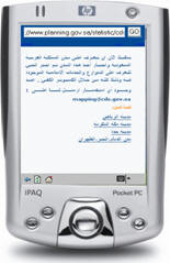
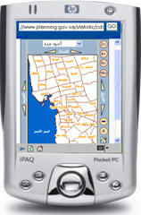
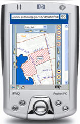
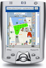
Figure 2 shows a wireless GIS for main
cities in Kingdom of Saudi
Arabia.The
application was developed for Riyadh-Jeddah-Makkah Almokarama and the
Eastern cities.The user can select the city and search for any service
and locate it on a detailed map.
Conclusions
The classic GIS market will change drastically in the coming few years and the emerging technologies will change its future, moving GIS from the office desktop into the users' hands.Mobile GIS brings GIS out of its specialized niche or isolated island into the broader information technology market.
References
In the future, many computer applications will be inherently mobile, and rely on seamless wireless networking.Although the desktop computer will still exist and be used for many tasks, the majority of tomorrow's computer applications will be accessed on other devices.The integration between telecommunication and data communication will contribute to the creation of a global networking infrastructure that is seamlessly available anytime, anywhere, and through a multitude of different devices.Given the assumption that this global network will soon be available, application designers will find that a number of properties of mobile computer use are unique for this setting, and constitute very different requirements on design and implementation than those have been established for stationary applications.I have helped develop a wireless GIS for many cities in the Kingdom of Saudi Arabia, and in this article I will share some observations based on that experience.
Mobile Mapping Applications Properties
The requirements for mobile applications are very different from stationary applications.There is a need for a general and coherent design approach that addresses properties unique to mobile applications.These properties are summarized as follows.
- Same application, many devices. In a mobile service environment, there will be a plethora of terminals (small- and medium-sized mobile devices).Services must be able to present themselves on many of these, with consistent functionality and understandable interfaces.
- Same applications, many places. In the mobile "always on" world, people access services and information independent of location and time.
- Access variability.Universal access will always be relative.Roaming between various wireless technologies and operators will cause bandwidth fluctuations.Some services allow position-based functionality while others do not.Mobile applications must be able to adapt to these changing conditions.
- Merging digital and physical realms. In stationary settings, the digital and physical worlds are more or less separated.By contrast, in mobile systems they may be combined. Involving real world data such as geographic position, temperature and traffic gives us the chance to have more real time applications.
- Data scalability. One of the most important considerations is the data scalability.Data scalability refers to the flexibility in the amount or level of detail that can be provided over the wireless network.In order to maximize an application's efficiency in providing data, developers must allow for this flexibility.
- Data architecture. Another important factor to consider during design and implementation phases is the data architecture.In many cases, content of the system will reside on some type of application server.When the content needs to be updated, or additional information added to the system, developers must ensure that there will be a minimal disruption in the service.
The term "Mobile GIS" can be defined as an integrated software/hardware framework for the access of spatial data and services through mobile devices via wireline or wireless networks."Wireless GIS" is a subcategory of mobile GIS technology that focuses on the wireless networking capability of mobile GIS services.There are two major application areas of mobile GIS.
- Field-based GIS, which focuses on GIS data collection, validation and update (spatial and attribute).
- Location-based services (LBS), which focus on business-oriented location management functions, such as navigation, street routing, finding a specific location or tracking a vehicle. (According to information released by NOKIA this year, today's LBS service and products market is worth 10 billion Euro.)
The architecture of mobile GIS is very similar to that of Internet-based GIS, using a client-server architecture.Client-server applications usually implement what is referred as a Three Tiered Architecture.This architecture divides the application into a presentation tier, a business logic tier and a data management tier. Each tier can be replaced or updated without affecting the others.
The presentation tier consists of client side components which are used to send requests to the server and to view the results (maps and data). The business tier is the core of any solution and consists of the server side components including the Web server and application server. The data management tier is responsible for the management of both spatial and attribute data in the application.In some cases, one server is used for both the business and data management tier.In other cases each tier can be on a separate server.
LBS Application Opportunities
Applications that use LBS are limited only by developer's imagination, but there are some categories where needs opportunities have been clearly identified.
- Mapping, navigation and directions applications
- "Finder" applications that use the user's location to help locate something
- Location-based reminder applications that prompt uses when they reach particular locations, displaying, for example, a restaurant list
- Emergency services (such as the Enhanced 911 in the United States and E112 in Europe).
LBS is anywhere, anytime mobile computing.In practice, it represents the merger of four technologies: Personal Digital Assistants (PDAs) and 3G (3rd generation) mobile phones; location acquisition (automatic or manual); wireless Internet technology and infrastructure; and GIS solutions for wireless (data and application).The last three are discussed further below.
Location Acquisition
For applications to become location-aware, the wireless network must trace the location of the wireless device.This can be done either automatically or manually.Automatic location acquisition uses a positioning network to locate a device using technologies such as GPS or cellular base stations.
Each of these automatic positioning technologies has its advantages and disadvantages.Cellular base stations are ubiquitous across most urbanized areas, but their positioning is not precise enough to accurately locate a user (accuracy within tens to hundreds of meters). In contrast, GPS can be extremely precise (accuracy within meters), but in some cases the signal is obscured inside buildings and in areas with high traffic, narrow streets and high rise buildings.
Applications can be designed to enable quick manual inputs for location acquistion.These include using landmarks, stored locations or addresses and Zip codes.
Wireless Communication Network
Mobile communication is set to be one of the key technologies of the 21st century.Mobile phones have not only gained currency and acceptance worldwide, but did so with a speed that outstrips many other technical innovations at any point in history.Mobile devices satisfy a fundamental human need for communication and independence.The future of mobile communications lies in the extensive interaction of eyes and ears, mobile convenience at any time and in any place, in a way that is more natural than has ever been possible up until now.This can only be implemented on the basis of reliable and forward-looking transmission technologies.They form the foundation for progress in the world of communication.
As shown in Figure 1, one of the key 3G technologies is GPRS (General Packet Radio Services).It is an "always on" communication service that transfers information in the same way that Internet does by breaking data up into 'packets' that each follow their own, shortest available route to their destination, where they are reassembled at the receiving end.GPRS currently supports an average data rate of 115 kb/sec, but this speed is only achieved by dedicating all eight time slots to GPRS (the GPRS maximum theoretical data rate under perfect radio conditions is 171 kb/sec).For example, a GPRS device might be set to handle a maximum of four slots downstream and two slots upstream.Under good radio conditions, this yields speed of approximately 50 kb/sec downstream and 20 kb/sec upstream.This is more than three times faster than current (9.6-14.4kb/sec) GSM networks and roughly equivalent to a landline modem connection.
 |
EDGE (Enhanced Data rates for Global Evolution) is a 3G wireless technology that is capable of handling high-speed data.EDGE occasionally is called "E-GPRS" because it is an enhancement of the GPRS network.EDGE cannot be deployed by itself, it must be added to an existing GPRS network.EDGE's real world data rates are far lower than its theoretical peaks of 473 kb/sec.Users can expect average rates of 75-110 kb/sec.
WCDMA (Wideband Code Division Multiple Access) is a high speed 3G mobile technology adopted as a standard by the International Telecommunications Union.WCDMA can reach speeds from 384kb/sec to 2Mb/sec, which represents from 6 to 35 times more than what regular landline modems can do.
Development of Wireless GIS
When we are developing wireless GIS applications running on Pocket PC devices, we need to consider three elements: presentation, browser features and bandwidth.We can summarize the technical characteristics of each element.
Screen size limitations (presentation). The full screen size on a Pocket PC is 240 x 320 pixels.The usable content area in Microsoft Pocket Internet Explorer is 229 x 255 pixels.Sticking to these limitations saves the user from horizontal scrolling.Based on those dimensions, the map console is about 160 x 200 pixel.Another consideration is the Pocket PC built-in keyboard.When activated, it consumes 240 x 81 pixels of screen space.When embedding input forms, we must be sure that the form fields fit the screen width and test that the form is not obscured by the keyboard.
Browser features.The Pocket Internet Explorer (pIE) included with Pocket PC 2003 is, in many way, a considerable upgrade compared to previous versions.Here are a few of those upgrades.The pIE on Pocket PC 2003 supports HTML 4.01 and most pIE support a subset of the HTML 3.2 standards.The Microsoft JScript 5.5 support is now up to the same level as in Microsoft Internet 5.5, which means that most scripts written for desktop applications will be able to run on Pocket PC 2003. (As a rule, use the specifications for JScript version 1.1 to make an application accessible to most Pocket PC users.Jscript support in pIE has its quirks.For example, pIE cannot support multiple browser windows, it uses a single window only.) XML is generally supported in pIE and has the same capabilities as Internet Explorer version 5.0. VBScript is not supported but xHTML is supported (xHTML is a common standard when providing Web content to mobile phones).DHTML is not supported on pIE versions prior to Pocket PC 2002 because of lack of Cascading Style Sheets (CSS) support.pIE currently supports GIF, JPEG,PNG and BMP graphic formats.Finally, Macromedia has created a flash plug-in for pIE.
Band width. The wireless applications can be accessed through wireless LAN or through GPRS connections.The main development considerations are reducing the size of data transformed via the mobile network, reducing the response time of accessing data via mobile network, and providing a data cache on the client.We should remember that user will pay a per-packet fee to view the content when accessing the application through GPRS.
 |
 |
 |
 |
Conclusions
The classic GIS market will change drastically in the coming few years and the emerging technologies will change its future, moving GIS from the office desktop into the users' hands.Mobile GIS brings GIS out of its specialized niche or isolated island into the broader information technology market.
References
- Wireless and Mobile ad hoc Networking and
Computing.Journal
of Parallel and Distributed Computing.63 (2003).
- Shuichi Takino:To Realize Wireless GIS
Network by Java Mobile Phone.International
Symposium on Asia GIS 2001.
- Kjedskov, J.2002 "Just-in-place" Informationfor Mobile Devices Interfaces, Proceedings of Mobile Human Computer Interaction.Mobile HCI 2002, Pisa, Italy.
- Eunkyu Lee, Mi-Joeng Kim, Minsoo Kin and
Byung-Tea Jang: Network Perspective for Spatial Data Distribution to
Wireless Environment.12th Int.Conf.on Geoinformatics, Sweden, 2004.
From Our Homepage
Saying Farewell to an Amazing Journey
Communicating with Maps
Is There a GIS Career Ladder?
What does it mean to be geospatially smart? Series
Ways Real Estate and Property Developers Utilize Melissa GeoData for Data-Driven Decisions
Unlocking Value From Daily Satellite Imagery and Insights
Maximizing the Value of Your Address Data with Geo Addressing
How Indoor Mapping Enhances the Security of Smart Buildings
Look Ahead: AI, Location Intelligence and Efficiency
Collaboration Takes on Sea Level Rise & Dynamic Technology Environments
Brownies for Brownfields
Has Everything Been Mapped Already?
How Is Data Literacy Changing in an Artificial Intelligence Landscape
Portfolios for GIS Professionals: More Than Just Maps
How to Create a Distance Matrix in QGIS - A Step-by-Step Guide
7 Ideas for Bringing GIS into the K-12 Classroom
The Geography of Movement