Three critical
technologies are poised to converge over the
next few years and culminate into a suite of capabilities that will
have
significant implications in business, government and homeland security.
Each of
these technologies in and of themselves provide significant
capabilities and
value to organizations, but combining the new capabilities, including
Location-Based Services (LBS), will allow organizations to
fundamentally
rethink how they operate.LBS is rapidly becoming recognized as a
natural continuation
of the entire mobile/wireless computing and communications movement.
As Directions Magazine readers know, GIS combines layers of information about geographic locations to give the consumer a better understanding of that location-based data. The typical GIS include multiple layers that drill down into more and more detailed information.What layers of information you combine depends on the specific purpose of your analysis.Purposes could include: finding the best location for a new store, analyzing storm damage, viewing criminal activity, tracking terrorism and a terrorist network, and so on.The use of GIS is typically combined with other technologies such as an enterprise data warehouse, executive information systems, or decision support systems.
Communication technology is a loose collection of capabilities to transmit voice, data or images from one place to another.It is the foundation upon which organizations operate.Communications technology includes but is not limited to wireless, satellite, wired, and optical modalities of transfer.Substantial funding, government backed as well as private and institutional investment, has pored into this sector for decades.Advancement continues to press the capabilities and efficiencies of our communications infrastructure, and this trend is expected to continue for the foreseeable future.Due to the broad definition of this technology sector and the significant number of businesses offering solutions in this area, many industry analysts believe an over-capacity condition exists today.This and economic pressures will cause a consolidation within this sector that could slow the development of the next generation "integrated" communication platform.
Information technology is perhaps the broadest category and thus makes it difficult to bracket.The collection, processing, storage and dissemination of data, information or even knowledge are the heart of this industry sector.A tremendous amount of dollars have been invested in this sector over the last three decades.This investment has provided increased productivity and efficiencies that have benefited business, government, and industry, as well as impact our culture.
The culmination of these three technologies creates a robust platform from which organization can derive value.The ability to extract value from the integration of these three areas of technology requires continuous improvement in data collection sources.One such source of high fidelity data is in the area of remote sensing.Remote sensing is the science of deriving information about geographic areas from images and sensor data acquired at a distance.
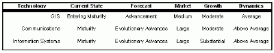
This table looks at each of the three technologies and puts them into context.
Click image for larger view.
This technology for acquiring data and information about an object of study by a device not in physical contact had its roots in the defense and intelligence communities.Now it is widely available to non-governmental organizations and widely used in many industries like insurance, to track storm damage, for example.Usually this is carried out by satellite and/or aircraft.Advances in this technology and increased capacity have made this much more cost effective over the past decade.Many technology analysts have expected remote sensing to produce fundamental changes in the way people think about geographical information.However, after continuous advancement in this area, today the magnitude of its future effect on GIS and information cognition is not clear.Much more research and development still remains to be done.
All these technologies must become seamlessly integrated and much more easily deployed if they are to reach their true potential. Not an easy task given the independent silos each of these industries operate within.Competitive and economic issues are driving cross industry cooperation that may serve as the catalyst that will accelerate the evolution of a true operational platform. But what is the "killer-application" that will create the compelling case for action? There are two, if you exclude Position-Based Gaming (PBG).In the interest of time I will not address this market and application segment.
The first is in the defense arena.The program is called Net-Centric Warfare.This is a cooperative effort between industry players to create fully integrated program with all aspects of the battlefield and warfare.The goal of this program is for a fully integrated view of the theater of operation that is created by a platform based on a common set of standards.It is expected that tens of billions of dollars will be spent to achieve this goal.
The second killer "application" is LBS.LBS creates the opportunity to provide products or services to an entity based on their location at a given point in time.Many technologists commonly call this "On-Star" on Steroids.Convergence of a number of factors now makes it favorable for commercial location-based service offerings within the United States.Organizations are rapidly launching new services to compensate for the revenue decline in many traditional areas of the telecommunications industry.
An extension to LBS is currently being researched and a few fielded applications have been deployed.The next generates of LBS will integrate "Context-Based Services" (CBS).This is more than another hot buzz word. CBS allows an application or intelligent agent to initiate communications to obtain services based on the activities or conditions of the user or piece of equipment.
Homeland Security Application of LBS
LBS fits squarely in the problem-space of homeland security and defense.The application of this technology to emergency response is the very first area that has been identified.Dispatch and logistical provisioning are just two areas in emergency response that is currently being considered for development and deployment.The second area for application of LBS is in the area of critical infrastructure protection.Since our infrastructure systems are made up of geographically dispersed assets, organizations that are responsible for protecting critical infrastructure must be able to rapidly compile location-based data, monitor assets, and make this information available when and where needed during a time of critical crisis.LBS applications would fill a current void and serve many of the needs to collect and disseminate critical infrastructure information.
One significant roadblock exists that could hinder the culmination of the convergence of these three technologies.What is that? Standards! Lack of standards make it difficult to integrate these technologies with an organization's other information systems.The ability to share data between systems and between user communities still requires considerable time and effort.A second critical roadblock is competing agendas. Organizational cross boundary intelligence must be handled and all parties must be in agreement to share this information.The final roadblock is in the area of security. Our ability to protect information in these systems must continue to evolve and increase our comfort level with the open architectures that many of these systems are built upon.Cautious optimism is the consensus of top technology strategists.It is only a matter of time until these systems become the cornerstone for organizations of almost any size and in any industry.
As Directions Magazine readers know, GIS combines layers of information about geographic locations to give the consumer a better understanding of that location-based data. The typical GIS include multiple layers that drill down into more and more detailed information.What layers of information you combine depends on the specific purpose of your analysis.Purposes could include: finding the best location for a new store, analyzing storm damage, viewing criminal activity, tracking terrorism and a terrorist network, and so on.The use of GIS is typically combined with other technologies such as an enterprise data warehouse, executive information systems, or decision support systems.
Communication technology is a loose collection of capabilities to transmit voice, data or images from one place to another.It is the foundation upon which organizations operate.Communications technology includes but is not limited to wireless, satellite, wired, and optical modalities of transfer.Substantial funding, government backed as well as private and institutional investment, has pored into this sector for decades.Advancement continues to press the capabilities and efficiencies of our communications infrastructure, and this trend is expected to continue for the foreseeable future.Due to the broad definition of this technology sector and the significant number of businesses offering solutions in this area, many industry analysts believe an over-capacity condition exists today.This and economic pressures will cause a consolidation within this sector that could slow the development of the next generation "integrated" communication platform.
Information technology is perhaps the broadest category and thus makes it difficult to bracket.The collection, processing, storage and dissemination of data, information or even knowledge are the heart of this industry sector.A tremendous amount of dollars have been invested in this sector over the last three decades.This investment has provided increased productivity and efficiencies that have benefited business, government, and industry, as well as impact our culture.
The culmination of these three technologies creates a robust platform from which organization can derive value.The ability to extract value from the integration of these three areas of technology requires continuous improvement in data collection sources.One such source of high fidelity data is in the area of remote sensing.Remote sensing is the science of deriving information about geographic areas from images and sensor data acquired at a distance.
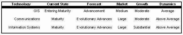
This table looks at each of the three technologies and puts them into context.
Click image for larger view.
This technology for acquiring data and information about an object of study by a device not in physical contact had its roots in the defense and intelligence communities.Now it is widely available to non-governmental organizations and widely used in many industries like insurance, to track storm damage, for example.Usually this is carried out by satellite and/or aircraft.Advances in this technology and increased capacity have made this much more cost effective over the past decade.Many technology analysts have expected remote sensing to produce fundamental changes in the way people think about geographical information.However, after continuous advancement in this area, today the magnitude of its future effect on GIS and information cognition is not clear.Much more research and development still remains to be done.
All these technologies must become seamlessly integrated and much more easily deployed if they are to reach their true potential. Not an easy task given the independent silos each of these industries operate within.Competitive and economic issues are driving cross industry cooperation that may serve as the catalyst that will accelerate the evolution of a true operational platform. But what is the "killer-application" that will create the compelling case for action? There are two, if you exclude Position-Based Gaming (PBG).In the interest of time I will not address this market and application segment.
The first is in the defense arena.The program is called Net-Centric Warfare.This is a cooperative effort between industry players to create fully integrated program with all aspects of the battlefield and warfare.The goal of this program is for a fully integrated view of the theater of operation that is created by a platform based on a common set of standards.It is expected that tens of billions of dollars will be spent to achieve this goal.
The second killer "application" is LBS.LBS creates the opportunity to provide products or services to an entity based on their location at a given point in time.Many technologists commonly call this "On-Star" on Steroids.Convergence of a number of factors now makes it favorable for commercial location-based service offerings within the United States.Organizations are rapidly launching new services to compensate for the revenue decline in many traditional areas of the telecommunications industry.
An extension to LBS is currently being researched and a few fielded applications have been deployed.The next generates of LBS will integrate "Context-Based Services" (CBS).This is more than another hot buzz word. CBS allows an application or intelligent agent to initiate communications to obtain services based on the activities or conditions of the user or piece of equipment.
Homeland Security Application of LBS
LBS fits squarely in the problem-space of homeland security and defense.The application of this technology to emergency response is the very first area that has been identified.Dispatch and logistical provisioning are just two areas in emergency response that is currently being considered for development and deployment.The second area for application of LBS is in the area of critical infrastructure protection.Since our infrastructure systems are made up of geographically dispersed assets, organizations that are responsible for protecting critical infrastructure must be able to rapidly compile location-based data, monitor assets, and make this information available when and where needed during a time of critical crisis.LBS applications would fill a current void and serve many of the needs to collect and disseminate critical infrastructure information.
One significant roadblock exists that could hinder the culmination of the convergence of these three technologies.What is that? Standards! Lack of standards make it difficult to integrate these technologies with an organization's other information systems.The ability to share data between systems and between user communities still requires considerable time and effort.A second critical roadblock is competing agendas. Organizational cross boundary intelligence must be handled and all parties must be in agreement to share this information.The final roadblock is in the area of security. Our ability to protect information in these systems must continue to evolve and increase our comfort level with the open architectures that many of these systems are built upon.Cautious optimism is the consensus of top technology strategists.It is only a matter of time until these systems become the cornerstone for organizations of almost any size and in any industry.
From Our Homepage
Saying Farewell to an Amazing Journey
Communicating with Maps
Is There a GIS Career Ladder?
What does it mean to be geospatially smart? Series
Ways Real Estate and Property Developers Utilize Melissa GeoData for Data-Driven Decisions
Unlocking Value From Daily Satellite Imagery and Insights
Maximizing the Value of Your Address Data with Geo Addressing
How Indoor Mapping Enhances the Security of Smart Buildings
Look Ahead: AI, Location Intelligence and Efficiency
Collaboration Takes on Sea Level Rise & Dynamic Technology Environments
Brownies for Brownfields
Has Everything Been Mapped Already?
How Is Data Literacy Changing in an Artificial Intelligence Landscape
Portfolios for GIS Professionals: More Than Just Maps
How to Create a Distance Matrix in QGIS - A Step-by-Step Guide
7 Ideas for Bringing GIS into the K-12 Classroom
The Geography of Movement