Maptech, Inc.
10 Industrial Way
Amesbury, MA 01913
http://www.maptech.com
Pricing
Terrain Navigator Pro is available in network and stand-alone versions.
Stand-alone versions are priced at $299.95 per state.
Introduction
Terrain Navigator Pro is a software program that provides access to
U.S. Geological Survey (USGS) topographic quadrangle maps and USGS Digital
Ortho Quarter Quads (DOQQs). The software allows the user seamless access
to the topographic maps across the state or region purchased. The topographic
maps are produced in two scales 1:24,000 and 1:100,000. The DOQQs are only
produced in a scale of 1:12,000. The DOQQs are accessed over the Internet
instead of the CD’s included with the product. The DOQQs need to be purchased
on an annual subscription basis from Maptech, but the first year is included
free with the purchase of Terrain Navigator Pro.
Getting Started
Terrain Navigator Pro includes a short manual for getting started that
is easy to learn and should have the user working with the software quickly.
The user specifies the USGS map data available when the software is installed.
I had received six CD for the state of Pennsylvania that contained all
the USGS topographic maps for the state. First, the user will specify the
area of interest with the Open Map interface. (See Figure 1) The interface
shows a map of the counties in Pennsylvania and a grid of the region of
the topographic map coverage that is on the current CD. The dropdown boxes
on the left allow you to specify the coverage of the map on the right,
the scale of the map type, the map name and the map reference code specified
by the USGS. You can select a map by simply double-clicking on a cell in
the grid or choosing a map name and press the Replace Archive button. The
Find button allows you to search for a map based on a street address, city/town,
zip code, place names, and by specific categories.
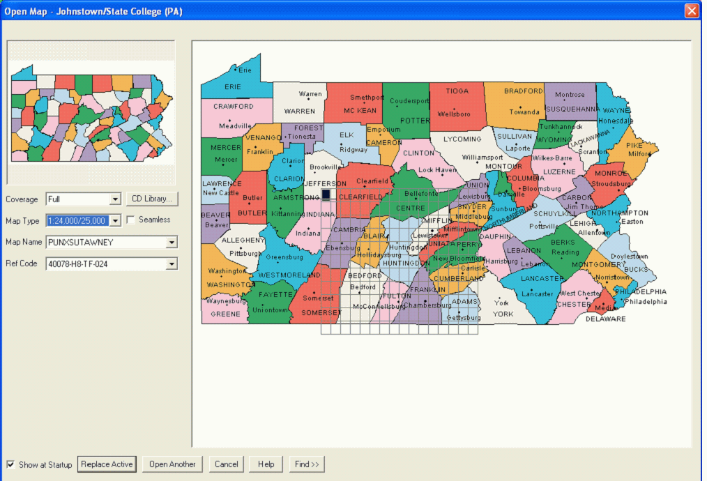
Figure 1: Open Map Interface (Click for Larger View)
Terrain Navigator Pro Interface
After a map is selected, the Terrain Navigator Pro window will open
with the map specified in the Open Map interface. (See Figure 2) The buttons
above the map include functionality that most GIS users are accustomed
to using: zoom-in, zoom-out, pan, center map, information tool, label tool,
and marker tools. The first button with the open folder, will take you
back to the Open Map interface to select a map another area. The button
with the check mark opens the Preferences dialog box where the user can
specify their individual preferences for various functionality included
with the product.
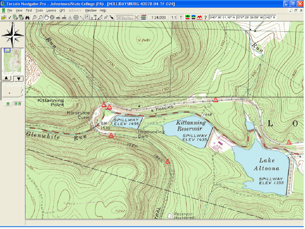
Figure 2: Terrain Navigator Pro interface
The objects to the left of the map provide additional functions. The directional arrow, allows you to push on an arrow to move the map around. The small overview map also allows you to move around the USGS topographic map by moving the blue rectangle to a new area on the overview map. You can open a large version of the overview map (See Figure 3) by pushing the triangle pointing upwards. You can then move the blue rectangle to another area on the overview map that will update the map in the main window to the area in the blue rectangle. The image of the state of Pennsylvania has a small red rectangle showing the current location of the map within the entire state. Lastly, the two buttons below the state map, allow you to switch between having one or two map windows open on the main map at the same time. You could have the topographic map open in one window and the aerial photograph open in the second window. (See Figure 4)
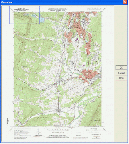
Figure 3: Overview Map (Click for Larger View)
The View menu provides the ability to change the map view. The View menu provides tools to control the zoom level, layer display and to create bookmarks. You can specify whether you want to view the maps as a single map or in seamless view. The single map view shows the USGS topographic maps in its entirety with the collars and printed information, where the seamless view removes the collars and you can move between the adjacent quadrangle maps seamlessly. Users can control whether they want to look at the maps in 2D or 3D. The software can create 3D visualizations of the topographic and DOQQ maps as shown in Figure 4. The 3D maps can be rotated and zoomed within the 3D map windows. Users can specify options such as the lighting of the 3D map in the 3D Preferences. The buttons to the lower left of the window control the height exaggeration, allow you to preview the image with 3D glasses, and create a 3D animation movie as an AVI file (compressed as an MPEG for publication).
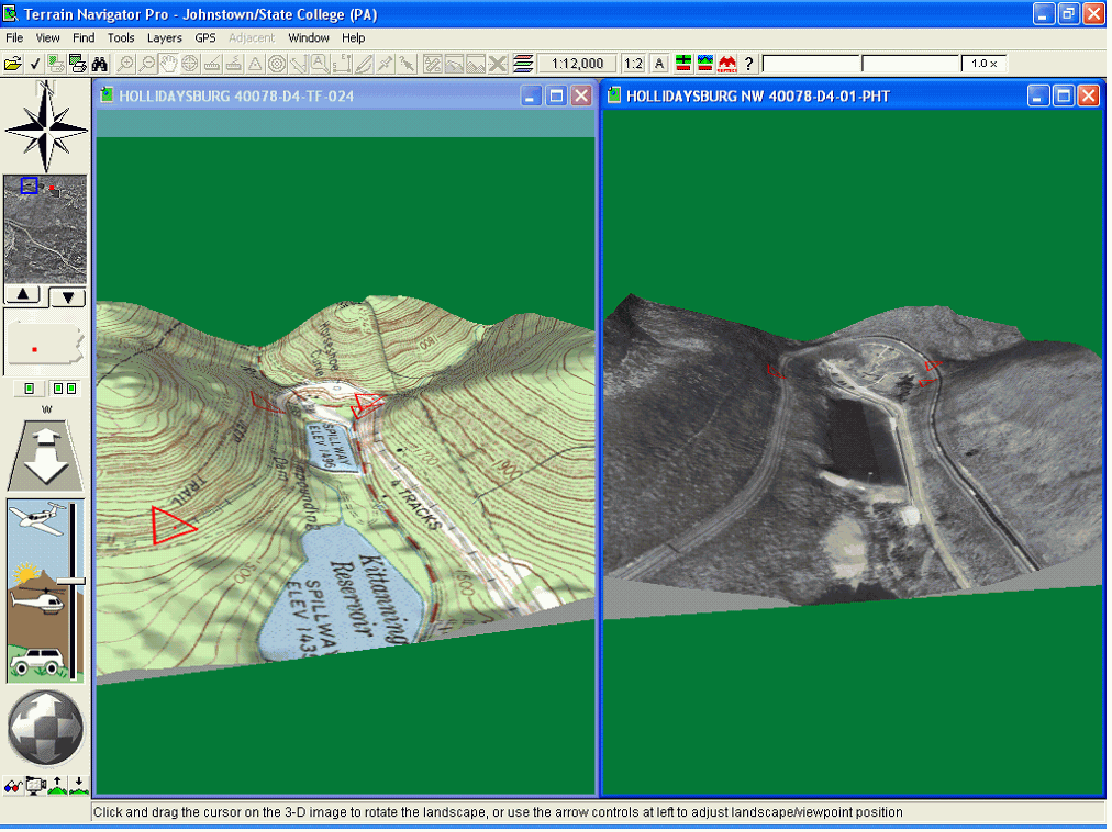
Figure 4: 3D visualization of a topographic and DOQQ
map
(Click for Larger View)
The range/bearing line tool lets you place a line on the map that will give you information such as the distance and bearing of the line. Range rings will draw circles around the area you click on the map similar to creating buffers around a point. You can set the style of the range rings, distance between rings and number of rings by using the Layers-Range Rings option. The route tool is used to create a travel path from a set of defined points. The points on the route can be edited along with inserting new points along the route.
The track tool can be used to draw a line on the map that can be used for profile analysis and line of sight analysis. Once the track is drawn on the map, the user can push the profile button or line of sight button to generate a profile of the elevation along the track created. The profile shows the total and ground distance information, lat/long, elevation change, and grade. The profile graph and the line of sight graph are exactly the same except the line of sight includes the sight line on the graph. (See Figure 5)
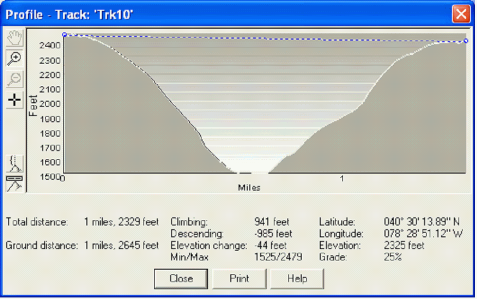
Figure 5: Line of Sight profile (Click for Larger
View)
Terrain Navigator Pro includes options to enable a GPS device to operate with the program. The software interacts with the GPS unit by sending data to the unit such as markers, routes and tracks while receiving information from the GPS such as waypoints, routes and logs. Terrain Navigator Pro supports GPS units from the major GPS manufacturers including DeLorme, Trimble, Magellan, Garmin, and others.
Map sharing is a way to copy maps from the CD’s to your hard drive so you do not have to keep switching out CD’s. The maps that are shared to the local drive will be displayed in the grid on the Open Map interface along with the maps that are on the current CD. Maps can be exported to raster formats that are compatible with other GIS programs, including ArcGIS and MapInfo, and desktop publishing and photo imaging applications. Terrain Navigator Pro includes two printing options: normal and quick print. The quick print option will print the map as it is displayed on the screen. The print button allows the user to add information to the output such as a caption, tic marks, and a north arrow.
ArcGIS Extension
Maptech provides a free extension to ArcGIS with the Terrain Navigator
Pro that can be downloaded from Maptech’s website. The extension allows
you to access the quadrangle maps as raster images within ArcMap and ArcCatalog
since the quadrangle maps are stored with different file extensions than
the raster image extensions that ArcGIS recognizes. Figure 6 displays the
topography maps and a zip code shapefile within ArcMap using the Maptech
ArcGIS extension.
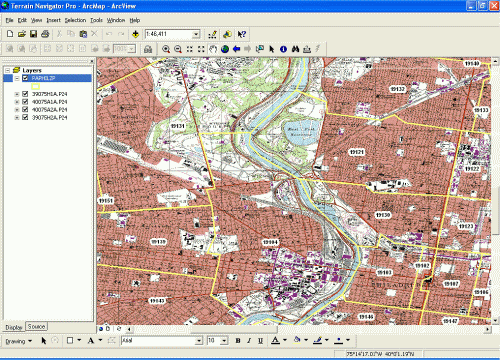
Figure 6: Terrain Navigator Pro topography map displayed
within ArcMap. (Click for Larger View)
Conclusion
Terrain Navigator Pro is a user-friendly software application for working
with USGS quarter quad topography maps and digital orthophoto quads. The
software and data are packaged together except for the aerial photography
that must be downloaded using the Internet on a subscription basis. The
software does an excellent job of working seamlessly between the different
quadrangle maps and the ability to display the quads in 3D is an extremely
powerful visualization of the information on the quadrangle maps. The software
can be used on a local machine or out in the field with the capabilities
to integrate the software program with information received from a GPS
unit. Maptech has also developed an extension to the product to work within
ArcGIS so that users can integrate the Terrain Navigator Pro data with
other types of geospatial data. Maptech plans to release a new ArcPAD Extension
which adds the ability to use Terrain Navigator Pro's topo maps, orthos,
and elevations files inside of ArcPAD.