Vendor:
GeoMicro, Inc.
201 East Sandpointe Avenue
Suite 410
Santa Ana, CA 92707
Tel: (714) 444-9240
Fax: (714) 444-9241
http://www.geomicro.com
Introduction
AccuGlobe is a new desktop GIS software application developed through
a partnership between GeoMicro, Inc. and Digital Data Technologies, Inc.
(DDTI). AccuGlobe was developed by DDTI using GeoMicro’s fourth generation
AltaMap components that are OLE/COM objects used to incorporate GIS functionality
into customized applications. The scheduled release date for AccuGlobe
is November 19, 2003. AccuGlobe has similar functionality to most of the
well-known desktop GIS software applications. The product was designed
to give most users the functionality they need on a daily basis.
AccuGlobe Business Model
AccuGlobe is distinguishing itself from other GIS software products
because distribution is completely free of charge. Users can download the
free software at www.ddti.net, and begin
using the software immediately. The product is free but there is a license
agreement and GeoMicro and DDTI retain ownership of their respective products.
Developers will be able to create new, royalty-free applications using
the AccuGlobe SDK that includes the Active Bar License, sample plug-in
code, as well as AltaMap Desktop SDK. The AccuGlobe SDK will sell separately
for approximately $2,600. DDTI will release a suite of AccuGlobe extensions
including an E-911 Extension for use in Emergency Dispatch Centers, AccuGlobe
Farmland Calculator, and AccuGlobe Data Explorer that corresponds with
the Nov. 19th release. GeoMicro will be releasing a national TIGER based
geocoder. Extensions will be licensed separately.
Functionality
The user interface of AccuGlobe is shown in Figure 1. The software
includes functionality to navigate around the map such as zooming, panning,
and a map magnifier window. The Identity, Measure, and Hyperlink tools
function exactly the same as other GIS software products. The Selection
tools include selecting features with a point, line, rectangle, circle,
or polygon, along with select by attributes and a clear selection button.
Once features are selected, you can zoom to the selected features or zoom
to a layer's extent. The Drawing toolbar provides tools to draw objects
on the map such as polygons or text and the options to change the object's
colors, fill patterns, font, or pen settings. The software includes a Buffer
wizard under the Tools menu with options to create buffers around objects
in the view. The Plugins manager includes the AccuGlobe Basic Editor plugin
that provides tools to edit shapefiles. Plugins can be started and stopped
based on the user's need for the plugins functionality.
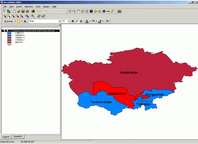
Figure 1: AccuGlobe User Interface (Click above for larger image)
The software supports adding data from the following data sources:
- ESRI Shapefiles
- MapInfo TAB files
- MrSID Image
- ERDAS Raster Format
- Band Interleave
- Image files such as JPEG’s, Gif’s, Bitmaps, and Tiff's
The software includes a Chart wizard that allows you to create five types or charts: Horizontal bar, Vertical bar, Pie, Vertical line and Horizontal line. Figure 2 is an example of a Vertical bar chart created with AccuGlobe. The wizard allows the user to set the title, X and Y Axes options, and a background color gradient. The wizard does not include options to set the grid size for numeric attributes and the only way to change the colors of the bars on the chart is to press the randomize button in the wizard until you see a pattern of colors that you like. I did not see an option for the user to manually specify colors. Charts can be saved to an AccuGlobe Chart Template file (*.ict) or exported as a Windows Metafile (*.wmf).
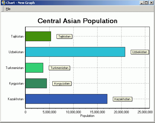
Figure 2: AccuGlobe Chart (Click above for larger image)
The final map in AccuGlobe can be exported to a Bitmap image file (*.bmp) The Print option allows the users to setup a layout of the map and other elements for final output. Users can add the map, charts, graphics, text, and images to the layout design window. You should be sure to set the map units in the View Properties prior to selecting the Print option because AccuGlobe will not open the layout design window if the map units are not set. I also did not see an option to add the legend on to the layout.
Conclusion
AccuGlobe is the first desktop GIS software program that I have seen
that is distributed free. Most GIS vendors distribute GIS data viewers
free of charge, but AccuGlobe is a desktop GIS software program that includes
a lot of commonly used GIS functionality. In addition to the product distribution,
users can download updates free of charge using the Web Update option that
is listed in the Windows Start menu. A couple of features in a GIS software
program that I think are common everyday functions that were not included
in AccuGlobe are the ability to have multiple map views in the same project
and the layout capabilities were somewhat limited. However, AccuGlobe has the "right price" and presents an good value despite these functionality
deficiencies.