Full text indexing has been one of the few new things to come from the introduction of computers. Everyone is hoping for at least one more clear benefit of the computer age. Speech recognition may be one. Matching images by content seems to be much more elusive. The idea of spatially indexing information, based on a geographic location, may be as powerful (and as tied to computers) as full text indexing has been.
In spatial indexing for records management, records are found based on their association with a place. Many records are tightly coupled to a place. Land records and most municipal government records are good examples.
Fiction could be indexed geographically based on the locating in which a story takes place.
Like other forms of indexing, geographic indexing can be combined with other indices. For example, one might as for all books of fiction that take place in upstate New York in the nineteenth century and that were written in the twentieth century.
USC has a project on the Internet in which archival records are indexed geographically. The project URL is: http://www.USC.edu/isd/locations/cst/IDA/prospectus.html
The City of Los Angeles GIS (Geographic Information System) is a highly integrated set of spatial (geographic) indices, including a composite and digitally rectified (the pixels are in the right place) digital orthophoto [http://mapping.USGS.gov/www/ndop] to represent images of things (such as buildings) in their true location. (The City is using a specially flown and processed image rather than the USGS image.)
The website given below gives everyone a chance to try out a fully developed spatial index. This index could be easily integrated with the USC project. For example, both systems use the same ESRI (http://www.ESRI.com) software and cover approximately the same geographic area. Linking the two would be something like cataloging books by looking up the Library of Congress classification (that is, easy and deterministic, yielding the same results for almost anyone doing the process).
Unlike traditional library cataloging, spatial indexing receives funding from sources such as real estate, civil engineering, environmental planning, disaster planning, and tax collection. Spatial indexing provides a method of synergistically extending the benefits of indexing expenditures, provided by various business activities, into other areas such as the humanities.
Eventually all materials will be spatially cataloged, and the richness of our record will have a new key (spatial indexing) to unlock access and provide a new perspective
Of course, spatial indexing is not for all books (or other items). Forcing spatial indexing when there is no identifiable geographic location is similar to insisting that every book be cataloged by author, even when no author can be identified for a given book. Because spatial indexing is now computer based, the existence of a spatial index need not impact the searches of people who have no use for spatial indexing.
The City of Los Angeles Spatial
Index
The City of Los Angeles has placed
just over 700 thousand images on the Internet. The system is also
designed to support as a map layer, a digital orthophotographic image (areal
photograph) that will provide a continuous tone image for the entire City.
Both the contone digital orthophoto and the more than 250 vector data GIS
layers will be available at continuously variable map scales to index documents,
and to provide a simple version of a VR (Virtual Reality) fly over of the
City.
The system also supports interactive
submission of large format images for the redlining of plans and the issuance
of permits over the Internet. The redlining capability can also be
used by field workers to input data, via the Internet, that can be used
to create real time maps of field incidents, events, and status on the
Internet. With this feature, users can provide system indexing.
This is similar to libraries adding printed bibliographies to their collections,
but the field works can do spatial indexing in real-time, in response to
events such as earthquakes, mudslides, floods, and fires.
The website for presented for the
GIS indexed documents and digital orthophoto is http://NavigateLA.LACity.org
or http://NavigateLA.LACity.org/samples/start
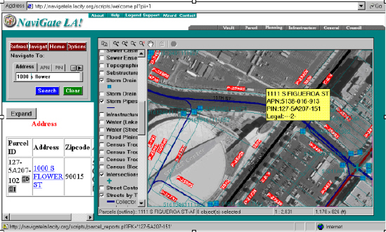
Navigate to Staples Center
The image below shows using three
methods of indexing: a relational database, and GIS vector data overlaid
on a raster based areal photograph.The P and D numbers are document index
numbers linked to a location on the map.
Note to Readers
Updates and More Detailed Descriptions
When using the information in this
article, please check the website
www.ArchiveBuilders.com
for updates. The version number of this article is just before the
page number below. The website also has articles that provide more
details on some of the terms and concepts in this article.
Comments
Please let us know how you like
this paper, or if you had any questions. What would you like to see
in the future? For more, and the most recent version of this article,
please visit our web site at www.ArchiveBuilders.com.
Please send your comments via email
to SteveGilheany@ArchiveBuilders.com.
Tel: +1 (310) 937-7000.Fax: (310) 937-7001. Also, please let us
know where you saw this article.
Acknowledgements
Reprinted from Archive Planning,
Volume 5, number 8, 2001, Archive Builders' analysis newsletter for document
management.
See www.ArchiveBuilders.com.
All trademarks are the property
of their respective holders.
Author
Steve Gilheany is a Sr.Systems
Engineer at Archive Builders. He has worked in digital document management
and document imaging for twenty years.
His experience in the application
of document management and document imaging in industry includes:
aerospace, banking, manufacturing, natural resources, petroleum refining,
transportation, energy, federal, state, and local government, civil engineering,
utilities, entertainment, commercial records centers, archives, non-profit
development, education, and administrative, engineering, production, legal,
and medical records management. At the same time, he has worked in
product management for hypertext, for windows based user interface systems,
for computer displays, for engineering drawing, letter size, microform,
and color scanning, and for xerographic, photographic, newspaper, engineering
drawing, and color printing.
In addition, he has nine years of experience in data center operations and database and computer communications systems design, programming, testing, and software configuration management. He has an MLS Specialization in Information Science and an MBA with a concentration in Computer and Information Systems from UCLA, a California Adult Education teaching credential, and a BA in Computer Science from the University of Wisconsin at Madison. His industry certifications include: the CDIA (Certified Document Imaging System Architect) and the AIIM Master (MIT), and AIIM Laureate (LIT), of Information Technologies (from AIIM International, the Association of Information and Image Management, www.AIIM.org), and the CRM (Certified Records Manager) (from the ICRM, the Institute of Certified Records Managers, the official certifying body for ARMA International, the Association of Records Managers and Administrators, www.ARMA.org).
Contact:
SteveGilheany@ArchiveBuilders.com
Tel: +1 (310) 937-7000.Fax: (310)
937-7001
For more information, courses, and
papers:
http://www.ArchiveBuilders.com