The fact that you are reading this article in a magazine that has never seen a printing press tells us a lot about the ways that technology overturns things that we like to take for granted.A few years ago spatial technology (it was called GIS) was easy to take for granted.There were a few vendors, two or three trade shows and a cadre of users who had braved weeks of training and months of trial and error to become "GISers".We lived in a small, comfortable world protected by our jargon and arcane technology.Now spatial technology, hardly recognizable, has exploded into business, to the Internet, to our desktops and even our cars.We are being jostled down the mainstream at dizzying speed.
At ISSI we make a living by analyzing this increasingly complex spatial information management industry.Fortunately, we have some heavy-duty help from International Data Corporation (IDC), the largest technology analyst firm on the planet.Together with IDC, we have developed an approach for explaining and predicting the ways that the industry operates and evolves.The approach works for us.In this series of articles we will present that model in hopes that it will prove useful to Directions readers.
| " We based our SIM industry segments on user requirements rather than the activities of vendors and the "technology du jour"" |
Our approach has two main parts.The first is a model that describes the major SIM industry segments.The second part is a model that describes how different vendors and their technologies fit together to deliver solutions for customers.IDC has been using this model since 1995, when Dr.Henry Morris, IDC's VP for Data Warehousing and Information Access, developed the Application Ecosystem model.More about the Ecosystem model in the next article.First, we need to describe our approach to segmenting the SIM industry.
We based our SIM industry segments on information a level above specific software technology, focusing on user requirements rather than the activities of vendors and the "technology du jour" .This time-tested approach has produced robust models and good advice for clients.For example, the technology for serving map data across the Internet may be in rapid flux, with boom and bust cycles in rapid succession.But the driving requirement is for more intimate interactions between customers and businesses.So, our model focuses on requirements for customer intimacy rather than the latest Internet map servers.
Industry models are interesting, but it takes data to make them useful.Data for this model comes from three sources.First, we took SIM revenue and growth data from IDC's annual Global Information Technology Survey of over 2,000 software vendors.In a separate survey, IDC and ISSI contacted IT professionals in over 1,800 medium and large companies to ask about their use of SIM technology.Finally, we used data from a survey developed with Microsoft of over 1,700 business professionals to estimate the importance of geographic information in their jobs.(The detailed data from all these surveys will be available from IDC in their report "Spatial Information Management: 1999 Worldwide Markets and Trends" in early September.Information on the 1998 report is here.)
In analyzing data from these surveys, we found distinct sets of user requirements for SIM technology.Working from these user requirements, we divide the SIM industry into three segments: GIS, Business Support Systems and Personal Productivity.As shown in Figure 1, a fourth segment, Internet, overlays the others.
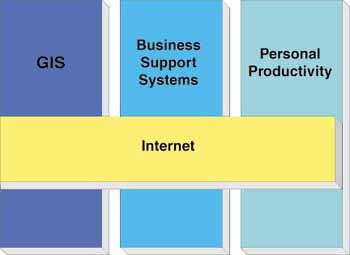
Figure 1: SIM Industry Segments
In each segment, basic spatial information handling technology is similar.But the similarity ends there.Each segment represents a unique set of user requirements.Each segment is a unique market with its own applications, data and distribution channels.Vendors who are very successful in one segment generally have a tough time moving to another.The success factors in each segment are just fundamentally different.
Now, lets take a look at the high-level differences between SIM industry segments.We'll cover the details in subsequent articles.
The key requirement for the first segment, GIS, is to handle geographic information well.For GIS users, geography is the most valuable information that they manage and that is what sets GIS apart from other information systems.
GIS systems are designed for the heavy lifting in spatial data conversion, analysis, modeling and cartographic display.GIS companies are geared to deliver these specialized solutions.These companies are accustomed to being the center of their customer's attention.ESRI is perhaps the paradigmatic GIS company.
The key requirement for Business Support Systems is to support specific business processes.Since business processes are quite diverse, Business Support Systems includes a diverse range of applications: Enterprise Resource Planning (ERP), On-line Analytical Processing (OLAP), data mining, Customer Relationship Management (CRM), Decision Support Systems (DSS).From a spatial technology perspective, Business Support Systems have one thing in common - geography is not the most valuable piece of information that they manage.
| " Vendors who are very successful in one segment generally have a tough time moving to another" |
The key requirements for Personal Productivity Applications are to assemble, analyze and communicate information that users need in their day-to-day jobs.Office suites, like Microsoft Office, are the most widely used personal productivity applications.
These office suites set very high standards for ease of use, integration with other applications, and low training costs.Companies like Microsoft set very high standards for distributing and supporting suites.
Where does spatial technology fit in with personal productivity applications? In a recent survey of business professionals that ISSI conducted with Microsoft, we found that about 50% of MS Office business users felt that geographic information was at least somewhat useful in their jobs.About half of these users felt that being able to communicate with maps would be useful in their jobs.That comes to about 20 million potential customers.Products like MS MapPoint 2000 are beginning to address the need, but this market is still in its infancy.
The key requirement for the Internet is ...Well, the Internet is different.The Internet affects all SIM industry segments.The internet is becoming the critical deployment platform, rapidly replacing client/server as the dominant system architecture.The Internet lets individuals collaborate over great distances.The Internet also allows the user to be insulated from difficult or compute-intensive tasks that are best handled on a specialized server.As an aside, the Internet is making some traditional analysis methods more difficult.How, for instance, do we use address data to help predict retail sales when the customer's address is a URL?
Will there be a unique Internet segment for the SIM industry? Maybe.There is a small and rapidly growing set of products that serve spatial information across the Internet.Products like MapQuest provide simple directions and address locations.Products like Autodesk MapGuide and MapInfo's MapXtreme address broader business needs.Oracle 8I promises to add significant new capabilities for spatial information processing across the Internet.Potentially, products like these can have a huge impact on the way that SIM technology is deployed and used.
In future articles, I will discuss each segment of the SIM industry in detail.I will also outline IDC's Application Ecosystem model and discuss how it helps us understand the ways that the SIM industry is likely to evolve.
Part Two in this series.