Remote sensing with a small, unmanned aerial system can be used for a number of applications, including (but not limited to) security services, search and rescue, environmental monitoring, crop management and other agricultural activities, disaster management and emergency response, environmental monitoring, surveying, journalism, business and real-estate applications, and videography. But, to reach the fullest potential of any application, choosing the right sensor is paramount. When making that decision, here are some questions to consider: What are the project requirements? What are the project deliverables? What is the environment for data collection? What is the budget? How will the sensor be used? The following list highlights sensors and their major applications. All of these sensors can be fitted on a small UAS.
Hyperspectral Sensor
Hyperspectral imaging collects information from across the electromagnetic spectrum. The goal of hyperspectral imaging is to obtain the spectrum for each pixel in the image of a scene, with the purpose of finding objects, identifying materials, or detecting processes. Examples of applications that would use hyperspectral imaging are: mineral surveying, plant measurements, and water quality assessment (to name a few).
The example imagery below was taken with the BaySpec OCI-UAV hyperspectral camera (which acquires data in the visible to near infrared wavelengths).

Figure 1: OCI-UAV-1000 Flight Data example. Reproduced from http://www.bayspec.com/spectroscopy/oci-uav-hyperspectral-camera/.
LiDAR Sensor
LiDAR (Light Detection and Ranging) measures the distance to a target by illuminating that target with a pulsed laser light and measuring the reflected pulses with a sensor. Differences in laser return times and wavelengths can then be used to make digital 3D representations of the target. LiDAR is often times used for aerial mapping and imaging (including 3D display), creation of digital elevation models, and surveying and land-use imaging.
The example imagery below was taken with the Velodyne LiDAR “Puck” (which collects 300,000 points of data per second).

Figure 2: Example of data collected by the Velodyne LiDAR “Puck”. Reproduced with permission from Velodyne. See: http://velodynelidar.com/vlp-16.html.
Multispectral Sensor
A multispectral image is one that captures image data within specific wavelength ranges across the electromagnetic spectrum. Multispectral imaging measures light in a small number of spectral bands (typically 3 to 15) whereas hyperspectral imaging often times measures light in hundreds of contiguous spectral bands. But like hyperspectral imaging, the multispectral sensor is able to see visible light, infrared radiation, and ultraviolet light. A multispectral sensor is a jack-of-all-trades sensor, and can be used for a variety of applications.
The example imagery below was taken with the SLANTRANGE 3P Multispectral Sensor (which collects imagery in four spectral channels).
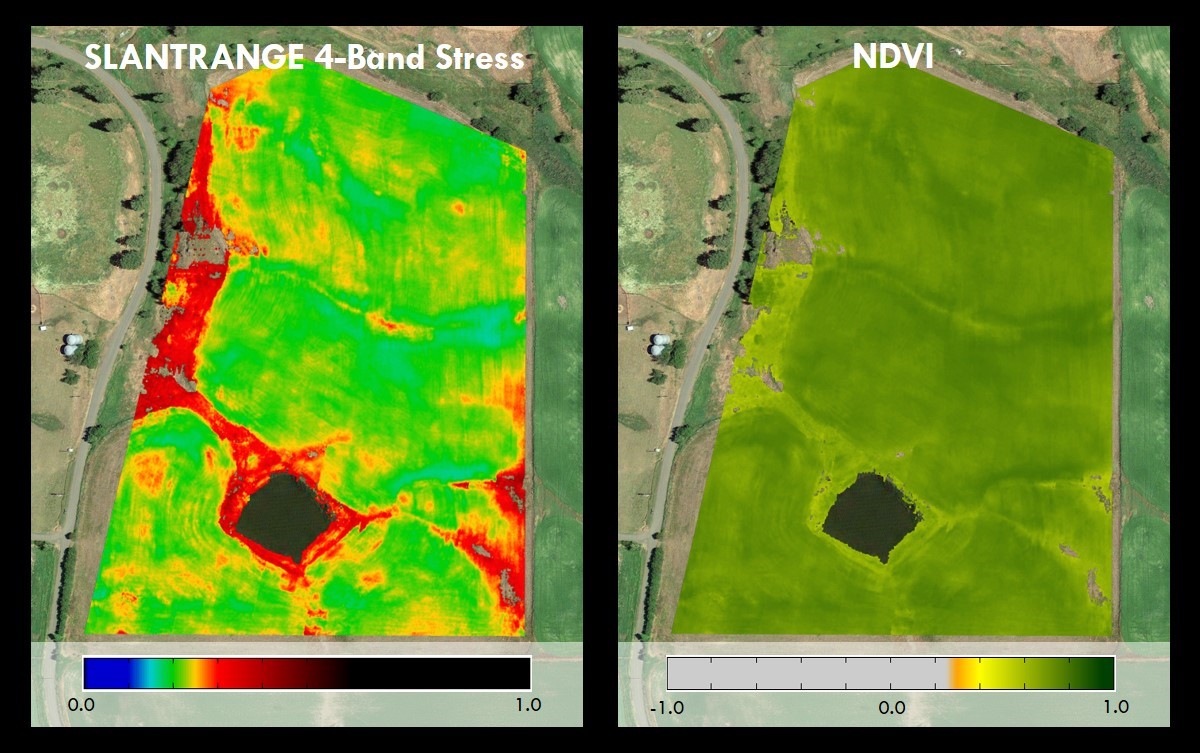
Figure 3: Example of data collected by the SLANTRANGE 3P Multispectral Sensor. The SLANTRANGE 4-band vegetation stress is more sensitive to early stress indicators than the simple 2-band NDVI on the right. The two additional bands are placed to measure sunlight absorptance by additional pigment types. Reproduced from http://www.slantrange.com/#section-slantrange-examples.
Thermal Infrared Sensor
Thermal infrared sensors measure heat emanating from an object. Generally, thermal infrared remote sensing is used for target acquisition, surveillance, night vision, homing, and tracking, environmental monitoring, and facility inspections.
The example imagery below was taken with a FLIR DJI Zenmuse XT thermal camera mounted on a DJI Inspire 1 Quadcopter.

Figure 4: Example of data collected with a FLIR DJI Zenmuse XT thermal camera mounted on a DJI Inspire 1 Quadcopter. Reproduced with permission from Dr. Wing Cheung, Palomar College.
Visual Sensor
A visual sensor, as the name implies, collects data in the visible spectrum (i.e., red, green, and blue). Visual imagery provides an aerial perspective of a specific area that can be used for visual inspection, mapping, photogrammetry, videography, and other uses.
The example imagery below was taken with a DJI Inspire 1 Quadcopter equipped with a 4K video camera (that takes 12 megapixel still imagery).
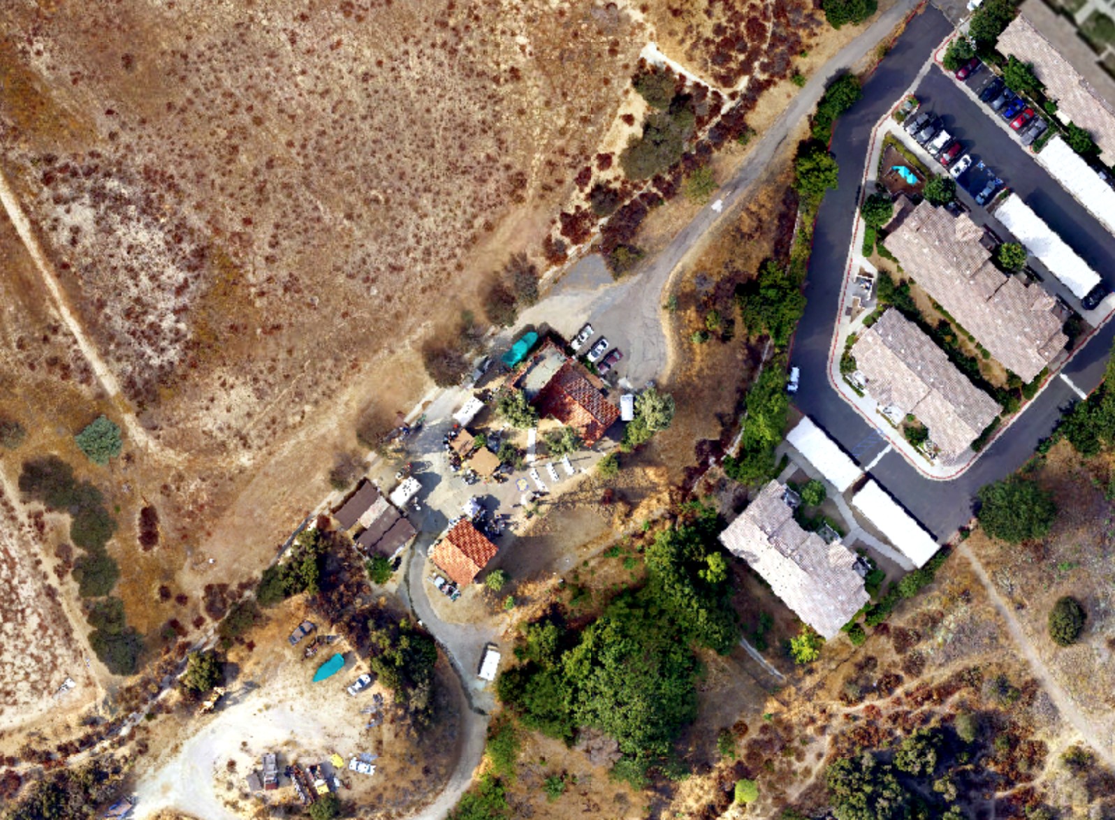
Figure 5: Example of data collected with the DJI Inspire 1 camera (at 12 megapixel resolution). Reproduced with permission from Dr. Wing Cheung, Palomar College.
Work reported in this article is supported by the National Science Foundation under Grant ATE #1700552. Any opinions, findings, and conclusions or recommendations expressed in this material are those of the author(s) and do not necessarily reflect the views of the National Science Foundation.
