While there are many UAS data processing software packages on the market – including some with extremely simple workflows – it can still be difficult to generate useful information from your UAS data. In this article, we will look at several steps in the data processing workflow that are critical for you to understand, but which are commonly overlooked.
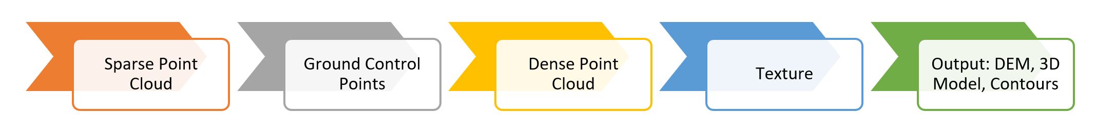
Figure 1: Key steps in a sample UAS data processing workflow.
1. Pay attention to the accuracy setting when creating your sparse point cloud.
Aerial triangulation, or the process of aligning overlapping aerial photos to determine the X,Y,Z coordinates of individual points, is often the first step in the workflow, leading to the creation of a sparse point cloud dataset used in subsequent processes. While a low accuracy setting will speed up processing and is great for previewing your model in the field, the sparse point cloud that is produced will be inaccurate relative to datasets produced with a high accuracy setting. Given that the sparse point cloud is used in subsequent processes, the errors in a poorly constructed sparse point cloud dataset can trickle down to other outputs (e.g., dense point cloud, digital elevation model) generated later in the workflow.
2. Manually remove outlier points early in the data processing workflow.
Failure to remove these outliers will increase the processing time in later stages of the workflow (e.g., constructing texture, mesh) as the software struggles to remove them in the best-case scenario. In the worst-case scenario, these outliers may lead to erroneous 3D models and ultimately inaccurate volumetric calculations.
3. Collect and use ground control points wisely.
An important step in the workflow is to refine your drone data and model using a set of carefully measured ground control points. Using ten or more points is a good rule of thumb, depending on the size and complexity of your study area. Aside from using a sufficient number of ground control points, it is also important to make sure that the ground control points are evenly distributed across the study area in order to ensure that the error is evenly distributed as well. In addition, the spatial reference (e.g., datum, projection) of the ground control points must match the spatial reference of the UAS data in order to avoid unintentional distortions that may be caused by projection mismatch or datum shift.
4. Review and clean your 3D model.
The 3D model generated by the software may be relatively clean if you painstakingly removed outliers in the initial steps of the workflow. However, there may still be legitimate features that need to be manually removed before you conduct volumetric analysis or area calculation. For example, in analyzing the volume of a stockpile, it is important to first mask out machinery, trees, or workers that are in the 3D model, so they are not erroneously included in the volumetric calculation.
Conclusion
Software developers have made it easier and easier for users to generate all kinds of UAS-derived output, with the click of a button in some cases — output like terrain models, orthomosaics, contours, and NDVI calculations. The inherent danger in this trend is that some users may not pay attention, may not understand, or may not be have the option, to change crucial settings in the workflow. Consequently, the output from the software may be perfectly acceptable for some applications, while completely inappropriate for other analyses and applications. It is critical that users learn as much as possible about their workflow settings (there are many more settings than we can covered in this article) and experiment, in order to generate the most useful data for their applications.