SPONSORED CONTENT
Anyone who has looked at flood data knows that FEMA is not the answer. It’s not that FEMA doesn’t try to accurately map what they believe to be floodable areas. It’s that FEMA is politically driven. As a city, you do not have to participate in FEMA mapping. Why would you not participate? Well, properties in flood zones tend to have lower valuations, and lower valuations tend to generate lower taxes. Even as an individual you can exempt yourself with a LOMA. A LOMA establishes a property's location in relation to the Special Flood Hazard Area (SFHA). LOMAs are usually issued because a property has been inadvertently mapped as being in the floodplain, but it is actually on natural high ground above the base flood elevation.
A Melissa customer wanted to sell flood insurance to prospects that were in flood zones but not likely to flood and not in flood zones but likely to flood. They had three primary targets, properties in 100 year flood zones that were not likely to flood, properties in a 500 year flood zone that were not likely to flood, and properties in FEMA minimal risk zones that were likely to flood. The customer realized that they needed a way to understand the current FEMA designation for the target properties but also have an independent flood likelihood evaluation of the property. For them, we created a sample set of customers utilizing HazardHub risk data that looked something like this:
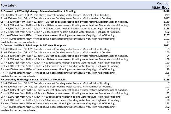
Then they created a targeted list by selecting B and C score prospects from the 100 year and 500 year flood plains and D and F score prospects from the minimal risk flood zones. This scoring and these selections are available nationwide and provided the customer with the ability to selectively target the types of customers that they were interested in from a risk exposure perspective. While this example discusses flood, this works for any natural hazard where properties are exposed, both personal property as well as commercial property.
If you have data challenges to solve, perhaps the Melissa team can offer the location intelligence solution needed. Melissa supports geospatial professionals in the goal of mapping innovation in location-based services, analytics and decision-making powered by location intelligence. We provide a wealth of location data enrichments including global geocoding to derive latitude and longitude from an address, and geo-enriched data for IP addresses. We offer other types of specialized data including U.S. property and mortgage data (type and number of buildings on a parcel, property age, construction, sales value, and more), demographics (household income, marital status, residence data, credit information, and more), and risk and natural hazard information (wind, water, ground and wildfire) that can be linked to location data to reveal relationships and trends. Our data feeds easily into popular data visualization and analytics platforms for ease of use and up-to-the minute accuracy. When you need to solve global challenges with geospatial technology, turn to Melissa – your single, trusted source for authoritative reference data.