Newcastle University Pioneers Hyper-Resolution Flood Risk Modelling using Bluesky 3D Aerial Survey Data
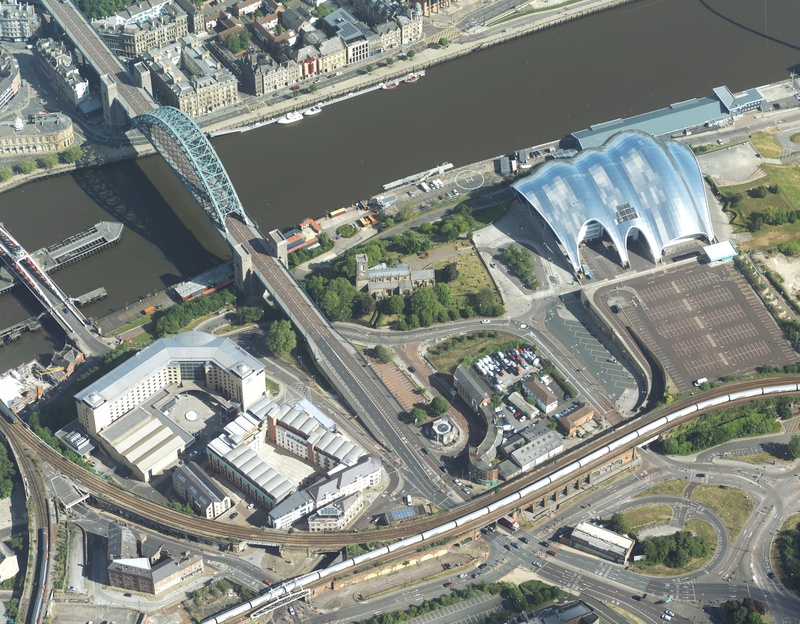
Leicestershire, UK, 24 February 2021 – Newcastle University is developing advanced computer modelling to assess the flood risk of individual properties using LiDAR data and oblique aerial photography from Bluesky. The project will use Artificial Intelligence to extract information from other datasets, including old reports and flood asset registers, and bring this together with weather and traffic sensors, for example, to provide a dynamic online platform for hyper local, near real time flood risk assessments.
Providing real world context and accuracy, the Bluesky data enables visualisations of evolving events that will enable flood risk managers to employ just in time maintenance and alleviation methods, such as clearing blocked drains or setting up mobile defences.
“In 2012 Newcastle experienced the worst flooding in living memory,” commented Dr Luke Smith, Lecturer in Data-Centric Civil Engineering and Deputy Director of the Urban Observatory at Newcastle University. “Referred to as Thunder Thursday and ‘Toon Flood’ this exposed a number of weaknesses in our existing flood modelling. We are, it would appear, incredibly good at predicting what roads will flood but not always its consequences for infrastructure, transport, and individual homes.
“The Bluesky MetroVista data combines LiDAR and photogrammetry, providing accuracy and detail that enable us to include information that is simply not available from a single source,” he continued. “For example, as part of this project we will consider the impact of property age and type of construction, we can look at the permeability of a house’s front garden and sometimes even door thresholds – all important considerations in flood risk assessment and mitigation at this scale.”
The Bluesky data is part of the MetroVista product range, which uses new aerial mapping technology to simultaneously capture vertical and oblique photography together with laser scanned height measurements. In addition to the Bluesky data the PYRAMID (Platform for dYnamic, hyper-resolution, near-real time flood Risk AssessMent Integrating repurposed and novel Data sources) project will use brand new information from a range of sensors deployed as part of the University’s Urban Observatory. The project will also use Artificial Intelligence and Machine Learning to automatically extract information from other data sources.
Captured using the world’s first large format imagery and LiDAR hybrid airborne sensor, the Bluesky MetroVista imagery collection includes simultaneously captured oblique and vertical aerial photography. The MetroVista datasets also include geographically accurate, phototextured, mesh models ready for use in 3D GIS, CAD and other modelling software as well as visualisation, gaming and Virtual Reality workflows.
About Bluesky:
Bluesky International is the leading aerial survey and geographic data company in the UK producing and maintaining seamless digital aerial photography and height data on a national scale in both Great Britain and the Republic of Ireland. Bluesky also undertakes bespoke surveys, including LiDAR, for a range of public and private sector clients.
Bluesky International operates a range of aircraft and sensors including three Ultracam Eagle Mark 3s, a CityMapper which allows the simultaneous collection of vertical and oblique imagery as well as LiDAR data, and a Galaxy LiDAR which is mounted with a thermal sensor and survey grade camera. These systems put Bluesky International in the enviable position of being able to provide customers with unique and cost-effective geospatial solutions.
As well as being an established and respected aerial survey company Bluesky International is also highly innovative and continually strives to develop new products and services by embracing new technology and methods. This has resulted in the development of some unique products such as the National Tree Map (NTM).
These datasets underpin long term contracts with local and central governments and many major blue-chip companies from a range of market sectors including financial services, utilities, telecoms, web portals, construction and environment. Bluesky International has offices in the UK, US, Republic of Ireland and a dedicated production centre in India.