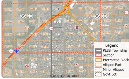
Free Public Land Survey System (PLSS) Data for Use with Maptitude Mapping Software

NEWTON, MASSACHUSETTS (USA) - Caliper is excited to announce the release of free PLSS and TXSS map layers. The Land Ordinance of 1785 established the Public Land Survey System, also known as the Township and Range system. Today the Bureau of Land Management maintains the Survey as a way to accurately categorize large areas of the Continental US. Area layers for the PLSS and for the Texas Survey System (TXSS) are now downloadable for free for Maptitude 2017 users.
The PLSS and TXSS are used:
- for administering lease programs by state oil and gas commissions
- for right of access management programs
- for local government parcel mapping
- for researching the ownership of Mineral Rights under a person's property
- for locating oil or gas wells by petroleum geologists
The downloaded layers can be added to any Maptitude 2017 map. The PLSS divides large areas of the USA into townships and sections (First Divisions and Second Divisions). The Texas Land Survey Layer splits the state into tracts, sections, and labors.
About Caliper
Caliper Corporation develops state-of-the-art Geographic Information Systems (GIS) software. With a focus on usability, Maptitude is designed to be a cost-effective, professional healthcare mapping software product. Maptitude enables organizations to leverage their location-based data to improve decision making and planning, while minimizing expenditure through competitively priced solutions.
Caliper is a privately held corporation and is a leading developer of mapping, redistricting, transportation, and GIS software.
"Maptitude has been an important tool for showing the geography of a variety of facilities and parameters, from rig trends by state, to patent trends by metro area, to the location of important infrastructure installations. Being able to illustrate and map these elements with Maptitude was essential for the analysis and, in addition, the software is backed up with outstanding support if needed."
Charlotte Batson
Petroleum Engineer / Shale Oil & Gas Con