DataCapable’s Success Enabled Through the Esri Startup Program - From Inception to Maturity

In the winter of 2015, geo-intelligence and customer engagement startup DataCapable was introduced to the Esri Startup Program. Like DataCapable, the program was in its infancy, although the value was immediately clear, “The Esri Startup Program afforded us the time and tools to bring world-leading geospatial technologies into our platform”, said Zac Canders, DataCapable’s CoFounder. “Esri has recognized the challenge that emerging businesses face to quickly bring their products to market and enroll customers. By providing emerging business with three years of free access to ArcGIS technologies and expert staff, the team at Esri is empowering new market entrants to drive innovation and demonstrate value across the world”.
A PATH FOR SUCCESS
Getting involved in the startup community required two foundational transformations at DataCapable. These are transformations that other startups may face. In the early days of DataCapable, maps were viewed as a necessary visualization, not as a key enabler of change and interoperability.

Image 1: DataCapable embraced the value of the program, at first thinking of maps as something that data sits on top of, then to thinking of maps as the foundation for everything to come.
The geospatial integration of ArcGIS tools and technologies into the DataCapable Platform (DCP) was an immediate task. Thankfully, the Esri Startup Program made this undertaking simple. By assigning expert technical staff, DataCapable had a clear support channel to solve the initial questions on integration and setup. Next, DataCapable had to embrace geospatial culture. This required becoming part of the global geospatial community. Luckily, the program provided a pathway for this as well. By offering startups attendance to conference and events across the globe, it provides a mechanism for startups to interact with potential clients, meet Esri partners, and embrace geospatial cultures across the world.
By embracing the technical requirements and geospatial community, DataCapable developed two-way integrations into Esri tools, found new clients, met new team members, and added localization (readying the platform for new languages and regions) to their platform. The Esri Startup Program laid the initial framework and DataCapable was ready for the next step in the program lifecycle.
COLLABORATION
For DataCapable,“ Esri’s Startup Program is all about collaboration” said Peter DiSalvo, DataCapable’s CoFounder. “The modern business needs to actively monitor and engage their customers at all levels across all social media platforms. Being part of the program has provided us an opportunity for us to share our integration with ArcGIS Online and enable existing Esri utility customers to maximize the value of their current enterprise GIS investments”.
By leveraging the tools and technologies provided in the program DataCapable had the opportunity to meet and collaborate with existing Esri partners. This included partners from weather leaders WDT, public safety leaders BAE, sensor historian experts OSIsoft, and systems experts Oracle. By combining data and technologies from these Esri partners, DataCapable transitioned into a collaborative partner that was ready to share real-time data with the partner and user community.
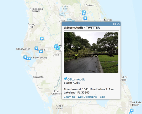
Image 2: During the 2017 hurricanes Irma and Harvey, DataCapable embraced Esri’s corporate principles and provided free access to the DataCapable Platform for utilities and first responders.
DRIVE INNOVATION - “MAPS ARE A SOCIAL CANVAS”
During the course of the following three years, DataCapable embraced the mission of the Esri Startup Program, and helped define the value of geospatial engagement and social media integration into map-based products and services. The program provided DataCapable with insights into the role maps play in customer engagement and communications. This has included numerous geospatial firsts:
- The 1st ArcGIS adapter for Facebook: Ability to embed the value of ArcGIS Online into a business Facebook page. By expanding the value of maps onto the largest social network, millions of users can engage with business through geospatial technologies on their preferred social platform.
- The 1st real-time layers in the Esri ArcGIS Marketplace: Numerous new machine learning-powered ‘Global Event Tracking’ ArcGIS Marketplace apps from social media for various use cases such as near real-time outage, wildfire, water quality, hail, tremors, boil water, flu, and gas leak maps.
GET INVOLVED TODAY
DataCapable recommends every qualified startup that could benefit from mapping and location intelligence get involved in the program! The future of GIS technologies will be defined by the interoperability and collaboration of new and exciting market vendors, and the Esri Startup Program provides a platform for emerging businesses to be part of this vision. By embracing Esri technology early in your company's development, your product teams will benefit from not having to rework or redesign existing capabilities. Your clients will also thank you for aligning to their existing enterprise geospatial strategy.
Most importantly, the Esri Startup Team deserves a big thank you! Their passion to help startups succeed is delivering change in geospatial technologies. The entire DataCapable team appreciates the opportunities this program and associated teams has provided us. We look forward to supporting the community in the future as a Silver Esri Partner.
About DataCapable
DataCapable is a B2B SaaS company that focuses on improving the communication gap between businesses, their customers, and the general public. This allows businesses to resolve issues as fast as possible with minimal overhead using communication channels that already exist. The DataCapable Platform (DCP) is a cloud-based (SaaS) solution that specializes in event detection, event notification, and event mapping. The DCP is fulling integrated with Esri GIS solutions.
About Esri
Esri, the global market leader in geographic information system (GIS) software, offers the most powerful mapping and spatial analytics technology available. Since 1969, Esri has helped customers unlock the full potential of data to improve operational and business results. Today, Esri software is deployed in more than 350,000 organizations including the world's largest cities, most national governments, 75 percent of Fortune 500 companies, and more than 7,000 colleges and universities. Esri engineers the most advanced solutions for digital transformation, the Internet of Things (IoT), and location analytics to inform the most authoritative maps in the world. The Esri Startup Program is a free three-year program that gives emerging businesses the tools to build mapping and location analytics capabilities into their products. Qualifying startups receive software, cloud services, training and support, and other opportunities to help them succeed. Visit us at esri.com.