 If
I worked at Swiss Re or Munich Re, I think I might want to take a look at the
map at right.The Wall Street Journal reported on Monday that the
two companies will have combined losses exceeding $1 Billion due to the
most recent wave of hurricanes pounding the U.S.coastline, especially
Florida.The information provided on these maps come from an interactive
mapping website maintained by the NOAA
Coastal Services Center, in Charleston, South Carolina, called Historical
Hurricane Tracks.According to NOAA, "The interactive mapping application
allows you to easily search and display more than 150 years of Atlantic
Basin and more than 50 years of East/Central Pacific tropical cyclone data.
New hurricane track data is added annually at the end of the hurricane
season." The website serves as a stunning example of the geospatial information
that is readily available through the Internet.As such, the map identifies
the historically most vulnerable areas for hurricane damage due to cyclonic
activity.
If
I worked at Swiss Re or Munich Re, I think I might want to take a look at the
map at right.The Wall Street Journal reported on Monday that the
two companies will have combined losses exceeding $1 Billion due to the
most recent wave of hurricanes pounding the U.S.coastline, especially
Florida.The information provided on these maps come from an interactive
mapping website maintained by the NOAA
Coastal Services Center, in Charleston, South Carolina, called Historical
Hurricane Tracks.According to NOAA, "The interactive mapping application
allows you to easily search and display more than 150 years of Atlantic
Basin and more than 50 years of East/Central Pacific tropical cyclone data.
New hurricane track data is added annually at the end of the hurricane
season." The website serves as a stunning example of the geospatial information
that is readily available through the Internet.As such, the map identifies
the historically most vulnerable areas for hurricane damage due to cyclonic
activity.
The growth of web mapping technology has altered the way that geospatial software development companies approach product planning and the manner in which certain component technology has been developed to accommodate sales opportunities.Internet mapping software platforms are now available for the intended purpose of supporting mainstream information technology systems for logistics, human resources, finance, and marketing.And niche applications for insurance, banking, real estate, and transportation have been developed to support web-based applications that operate company-wide so that more people can visualize geographically referenced corporate information.
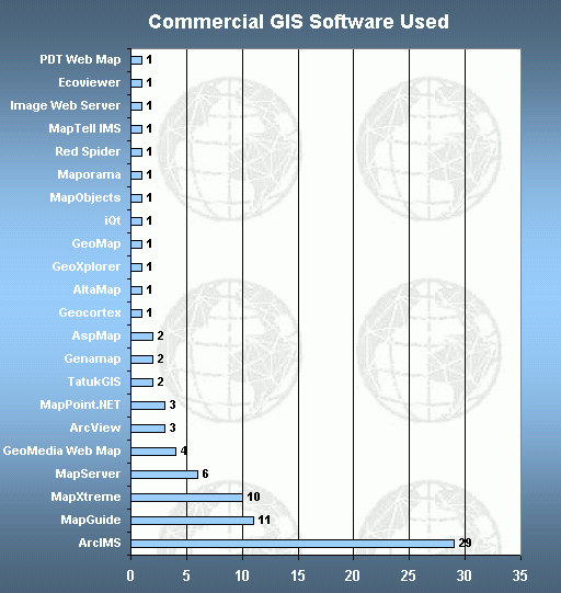
This week, Directions Magazine launches it second annual WEB MAPPING CONTEST sponsored with the help of Microsoft Corporation.Our intent is to both raise awareness of the myriad applications that have been developed in both government and private industry, and to have some fun as well.Last year, the contest drew 105 entries from around the world.We do require the contestants to provide useful information about their website, so that others can benefit from their efforts.For example, we ask contestants to provide the type of commercial GIS software tools used in the development of the web map.The chart below illustrates the types of software used by those submitting websites from last year's contest.And more information about the 2003 contest can be found in an article we published last year entitled, "The Making of a Web Map."
The entries will be judged by the readers of Directions starting on October 21st with the winners announced on November 1st. All entries will become permanently archived in our Web Mapping Gallery which serves as an excellent reference for anyone looking to see what others have developed.We hope you will participate with us.
[And for a little additional enjoyment, see Steve Lombardi's article,
"The
Oscars of Web Mapping." If you missed this article before, here's your
second chance!]
![]()