The Arches Project: Turning Open Source GIS into a Heritage Inventory and Management System


Summary:
The Getty Conservation Institute and the World Monuments Fund are working together to create new open source software purpose-built to help inventory and manage heritage places. It turns out those who work in cultural heritage need something more than a GIS.The Getty Conservation Institute and the World Monuments Fund are working together to create new open source software purpose-built to help inventory and manage heritage places. It’s called Arches and incorporates a broad range of international standards to meet the critical need to gather, access and preserve key information about cultural heritage. An alpha version of the software was made available in January 2013 on the Arches Project website. Directions Magazine interviewed Yiannis Avramides, program associate at the World Monuments Fund, and Alison Dalgity, senior project manager at the Getty Conservation Institute, to learn more about the effort.
Directions Magazine (DM): Arches is built on, among other things, core open source geospatial technology including PostGIS and GeoServer. Why would a heritage group choose Arches over building its own solution on those projects?Yiannis Avramides (YA): A critical step for any city, region or country that wants to be a good steward of cultural heritage is to build an inventory of heritage sites. Many heritage institutions have developed custom, sophisticated solutions, but at a considerable investment of time and resources for a sector that is often underfunded. On the other hand, particularly in the developing world, establishing such systems has been challenging, and many of the commonly available options fall short of meeting the needs of heritage institutions and do not provide a full set of tools for promoting the conservation of immovable heritage.The Getty Conservation Institute (GCI) and World Monuments Fund (WMF) are two of the leading organizations in the heritage field, and they jointly committed to address this need by developing Arches. With Arches, institutions can take advantage of a system that has been designed primarily around the needs of heritage data management, one that they can customize without restriction, and that comes with a broad range of international standards built in. Arches is easy to use and will be available for deployment on a local, regional or national scale. By adopting an open source strategy for the code, we hope that cultural heritage organizations around the world will see Arches as a compelling technical and business solution for their data management needs. This is what makes Arches unique.
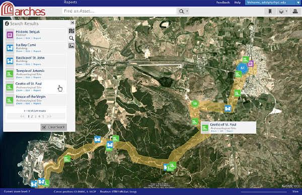
A mockup of the Arches UI: Arches will allow for searching for heritage within a user-defined polygon. This will, for instance, allow government authorities to determine which heritage would be impacted by proposed development projects.DM: Farallon Geographics built the initial version. How did that company get involved? What did it contribute?Alison Dalgity (AD): Farallon Geographics was selected by the GCI and WMF because of its expertise in developing innovative, open-source, geospatial solutions. We originally worked with Farallon to create the Middle Eastern Geodatabase for Antiquities, a Web-based inventory for archaeological sites in the Middle East, built using open source tools. The GCI and WMF formed a team that worked very effectively with Farallon, and together we gained a unique perspective on what it would take to create a system that could manage information about all types of immovable heritage, beyond archaeological sites, in any part of the world. In developing Arches we have been greatly helped by English Heritage and the Flanders Heritage Agency in Belgium, and we have sought input on requirements from many other institutions and professionals.Farallon was responsible for helping to define use cases for Arches and for the overall system design, development and testing. This includes developing and documenting workflows for implementing Arches, as well as preparing and loading legacy cultural heritage data into the system. I think that one of Farallon’s main contributions was seeing Arches as more than just integrating GIS into a cultural heritage database. For example, after listening to the requirements of potential users, Farallon recognized that Arches would need to implement an ontology to properly manage the complex relationships found in heritage data. Farallon also helped us recognize the need for an integrated search engine (Elastic Search) within Arches, and other discussions revealed that integrated thesauri based on Simple Knowledge Organization System (SKOS) are essential for managing taxonomies and controlled vocabularies for cultural heritage.
DM: The Frequently Asked Questions page has a detailed section that basically dispels the myths about open source software. That suggests that members of the heritage community are still new to open source. Is that correct? What other open source projects are used in the heritage management disciplines?YA: Like many communities, the cultural heritage community is very diverse. And while many members are well informed about the pros and cons of open source software, it’s probably fair to say that many are not. We feel that there’s a real opportunity here to educate members of the community who may not yet be aware that open source software is a viable business strategy for acquiring, deploying and extending enterprise data management solutions. And in every country, cultural heritage attracts attention from members of the public, and we felt it was our responsibility to explain our approach to them as well.One example of a heritage organization that currently follows an open source approach is the Flanders Heritage Agency in Belgium. Its current inventory system incorporates many of the same open source tools that are used in Arches, and the organization has generously contributed its expertise to this project because it believes that Arches and the open source approach could provide a solution that fits the needs of the heritage field at large.
DM: "Compliance with the OGC standards will ensure that the system is compatible with other desktop GIS applications (such as ESRI’s ArcGIS, Google Earth, or Quantum GIS), common web browsers, and online satellite imagery and maps such as those provided by OpenStreetMap, Google, and Microsoft.” Which of the standards are most important to those in the cultural heritage arena? Why?AD: Interoperability is crucial to the cultural heritage field. We believe that data access standards, such as those defined by the OGC, are the most important to the field. Supporting OGC standards means that we can ensure that Arches data can be accessed across vendor applications for use in spatial analysis or cartography. In the same way, supporting modern browser standards (such as HTML5, JavaScript, CSS3) means that Arches users can access cultural heritage data across a wide variety of devices.Because Arches data conform to a well-established ontology, we expect that Arches data will be published as RDF triples further supporting data access and interoperability, and will promote data longevity in the cultural heritage community.
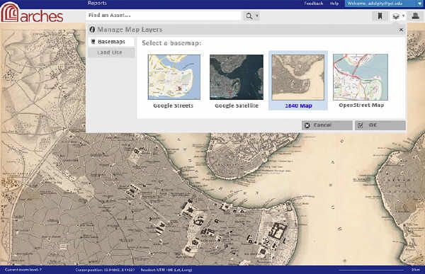
A mockup of the Arches UI: Arches’ Layer Library will allow selection of base maps, such as Google streets, Google satellite imagery, historic maps (as shown here), and OpenStreet Map.
DM: Considering the underlying technology (GeoServer, PostGIS, OpenLayers) this sure sounds like and looks like a GIS. Why, then, is it called a “Heritage Inventory and Management System”?AD: You’re right, Arches looks a lot like a GIS, but there are a couple of reasons why we call it a “Heritage Inventory and Management System.” To describe cultural heritage information properly, you have to manage very complex relationships between physical objects, conceptual objects, people and events. One way to visualize this is to think of cultural heritage data as a network of relationships among physical objects, conceptual objects, people and events, as opposed to a series of data layers as is the case in a traditional GIS. It turns out that managing these relationships requires an ontology of cultural heritage concepts. Arches implements the CIDOC Conceptual Reference Model, a well-established ontology that defines a formal semantic structure for describing the concepts and relationships used in cultural heritage documentation. On top of that, we discovered that the richness of heritage data means that thesauri are indispensable for an inventory system.All of this meant that simply calling Arches a “GIS” wouldn’t be accurate or reflect the real nature of the system. Given the project goals and the information management requirements, we felt that “Heritage Inventory and Management System” did a better job of communicating what Arches really is. And it’s certainly a lot snappier than “Geospatial and Semantically Enabled Cultural Heritage Information Management System”!
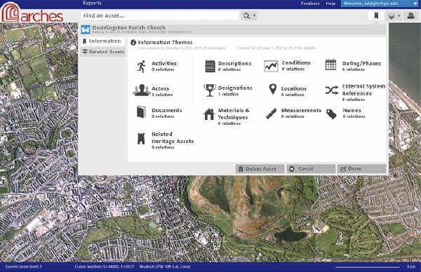
A mockup of the Arches UI: Arches will allow the recording of relationships between a heritage asset and, for example, activities (such as historical events or recent investigations), actors (such as historical figures, architects or organizations), and documents.
DM: Will some team members be at FOSS4G in Minneapolis in May?YA: Yes, members of Farallon’s staff plan to attend FOSS4G North America.


