
Best Gps For Hiking


Finding the best gps for hiking is easier once you separate easy day hikes from rough backcountry travel. A smartphone handles a lot of trail work well, and in fair weather it may be all you need. A dedicated handheld GPS still earns its place when battery life, glove-friendly controls, and reliable offline navigation matter more than a slick screen.
Handheld units have become more specialized over time. Your phone is faster, the display is sharper, and the mobile app ecosystem is better than most built-in GPS software. Still, a purpose-built satellite navigation device has advantages in rain, snow, or cold, and I keep coming back to that when the route gets serious.
I have tested these units across many seasons, and I still have a Garmin GPS 12 from 1999 that powers up without complaint. I would not point anyone to that old receiver now, but it does remind me how durable well-built GPS gear can be.
What I’d Choose
The Garmin GPSMAP 67i is the strongest all-around pick. It is rugged, accurate, and has unusually long runtime, with Garmin inReach built in on the 67i version.
The Garmin GPSMAP 65s is the value option I’d steer most people toward if budget matters. It uses AA cells, and in my testing its multi-band GNSS performance is right there with the 67i.
The Garmin Enduro 3 deserves a hard look if you are open to a GPS watch instead of a handheld. It covers most of the same ground from your wrist, though the small screen changes how you work with the map.
A phone plus a solid mobile app is still a good answer for casual hiking in mild conditions. You just need to account for the electric battery draw and protect the device.
I buy my own gear and do not take sponsorships, so my recommendations are based on trail use instead of marketing copy.
What to Look For
The main job of a handheld GPS is simple. It has to keep working offline, in bad weather, and under enough stress that a smartphone interface starts to feel flimsy.
- Route guidance that is easy to adjust on the trail.
- Offline maps and physical controls that still work in cold or rain.
- Battery life that lasts for days, not hours.
- Durability and waypoint support for repeated outdoor use.
- Useful data on screen, such as elevation or pace, without menu hunting.
- Modern GNSS support with real-world accuracy around 6 to 9 feet.
- Price and weight that fit the kind of hiking you actually do.
Handheld GPS pros are fairly straightforward.
- Reliable offline use and strong battery life.
- Better control than a phone when conditions get ugly.
The tradeoff is obvious. A handheld is another device to buy, update, and keep charged. Most are heavier than they ought to be, and some Garmin software feels like a snapshot from an older era of consumer electronics.
Handheld GPS cons are just as real.
- Extra cost and extra weight.
- Software that can feel dated.
Phone-based navigation has improved a lot, and for some trips it is enough. I still prefer to reserve my smartphone for phone duties in the backcountry and let a dedicated GPS carry the route work. When you are wet and tired, a button-driven unit can feel like a cleaner signal path than a glossy touchscreen.
GPS Picks
I have used the Garmin GPSMAP 67i for thousands of trail miles. It has a few rough edges in the software, but it has never left me guessing about position or direction.
Years ago, outdoor GPS buyers had more brand choices, including Magellan. In 2026, Garmin is the only company I see as a serious default for hiking handhelds. TwoNav makes units that feel closer to cycling computers, and that is fine for some users, but I still want full button control on a trail device.
| Model | Type | Battery Life | Weight and Portability | Satellite Messaging | Price Range | Score |
|---|---|---|---|---|---|---|
| Garmin GPSMAP 67i | Handheld | About 140 hours with Garmin inReach tracking, over 200 hours in GPS mode | About 8.1 oz, easy to carry on a strap or in a side pocket | Yes | About $600 | 9.5/10 |
| Garmin GPSMAP 65s | Handheld | Up to about 16 hours with AA batteries in typical use | About 7.7 oz, compact and easy to pack | No | About $350 to $400 | 9.0/10 |
| Garmin Enduro 3 | GPS watch | Measured in days, and much longer than most watches | Wrist-based and the easiest of these picks to carry | No | About $900 | 8.8/10 |
| Garmin Montana 700 series | Handheld | About 18 hours in GPS mode | Roughly 14 oz, bulky for hiking | Some models do | About $700 and up | 7.8/10 |
If you want a quick read, the 67i is the best overall choice, the 65s is the best value, and the Enduro 3 wins on portability.
GPSMAP 67i
The GPSMAP 67i is my best overall choice. It combines multi-band GPS and multi-GNSS support, and the position fix is usually around 6 feet in my field checks, even under tree cover or along a canyon wall. With Garmin inReach tracking set to 10 minutes and messaging active, I usually see around 140 hours of battery life. In GPS-only use, it can go well past 200 hours.
The inReach side works like Garmin’s dedicated communication units. You get SOS and two-way satellite messaging in one package. If your question is which GPS is best for hiking overall, this is the clearest answer on the page.
The weak point is the software. Garmin still runs an older interface here, and it has not changed much in recent years. I can live with that because it is stable. In mapping work, stable software matters more than flashy menus, and the same logic applies here.
Some hikers dislike the sealed battery. I understand that concern, but a small USB pack solves it quickly and can also top off a phone or headlamp.
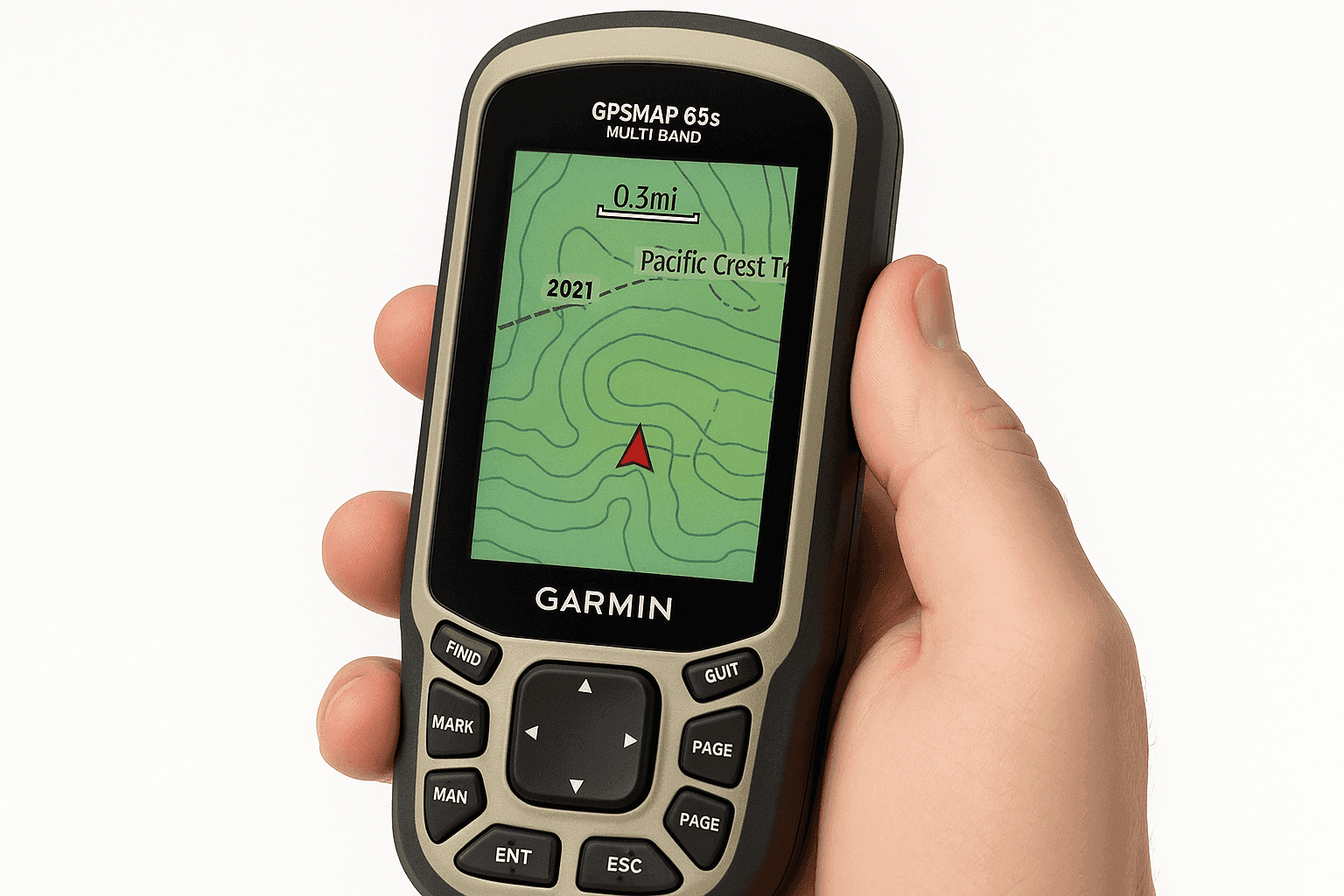
GPSMAP 65s
If you want the same core accuracy without Garmin inReach or the higher price, the GPSMAP 65s is the smart buy. It runs on two AA batteries, so power management in the field is straightforward. You can swap fresh cells in under a minute, which is still a real advantage on backpacking trips.
Accuracy was effectively the same as the 67i in my testing. You give up USB-C and the longer internal runtime, but the essential navigation functions remain. For many hikers, this is the best budget handheld GPS.
Other Handhelds
- Montana 700 series - Large touchscreen and a removable battery make it useful in a car or on a dashboard. For hiking, I find it too heavy.
- GPSMAP H1i Plus - Adds a camera and voice-note support over inReach. In my checks, the screen was dimmer and the GPS accuracy lagged behind the 67i.
- GPSMAP 66sr - This older multi-band model still works well, though the 65s covers nearly the same ground for less money.
Enduro 3 Watch
The Enduro 3 is the best GPS watch I have tested for hiking. If you are willing to treat a smartwatch as your primary trail tool, it can do almost everything my handheld does. You get offline maps with trail names and reliable tracking, along with solar support and battery life that stretches into weeks.
GPS watch pros are easy to see.
- Very light and always with you.
- Long battery life for a watch, with strong tracking.
The limitation is the screen. If you reroute often, or if you like working with a lot of map detail in the field, a handheld is easier. If your goal is solid mapping, tracking, and emergency rerouting, the Enduro 3 works very well.
GPS watch cons matter too.
- Small screen for detailed map work.
- Less comfortable for frequent rerouting than a handheld.
For easy hikes, a phone is usually enough. For rough weather or longer trips, I still trust a handheld more. A GPS watch sits in the middle if you value portability and can live with the smaller screen.
For easy hikes, a phone is usually enough. For rough weather or longer trips, I still trust a handheld more. A GPS watch sits in the middle if you value portability and can live with the smaller screen.
Phone as GPS
Your phone may already be the best hiking GPS you own for short trips in good weather. Modern phones often have assisted GNSS, strong processors, and displays that are easier to read than most handheld units. In open sky, the raw positioning can be surprisingly close to a multi-band GPS.
For casual hiking, I usually think a smartphone is worth using. The apps are smoother than Garmin’s built-in software, and route planning is faster. AllTrails is a good starting point for discovering new routes. Footpath is excellent when you want to sketch your own line and see distance or elevation quickly. CalTopo is the stronger tool for more serious map work, though the mobile app is simpler than the desktop experience.
Smartphone pros are obvious on the trail.
- Fast apps and a strong screen for map reading.
- No extra device to carry on short trips.
The weak spots are battery life and durability. GPS tracking can burn through a phone much faster than many hikers expect. I have watched battery forecasts fall sharply within the first hour when screen brightness stays high and the map is left open.
Smartphone cons show up quickly once conditions turn.
- Battery drain is much worse than many people expect.
- Cracks, water, or cold can turn the phone into a weak link.
- Carry an external battery so the phone does not become your single point of failure.
- Use a durable case. A cracked screen in the backcountry can turn into a real problem fast.
- Download maps before leaving service. Most apps make this easy, but you still have to remember.
Once conditions turn wet or extended, I switch. A handheld GPS or a GPS watch becomes primary, and the phone moves into backup duty. Is it worth getting a GPS for hiking? For easy day hikes, maybe not. For harsh weather, snow travel, or longer routes deep in the forest, I think the answer is yes.
Maps
If you have an older Garmin handheld that accepts added maps, or if you want another map source on a newer model, free OpenStreetMap topo layers are still useful.
Download your regional files from GMapTool, then use Garmin MapInstall and MapManager to load them onto the device. It works on Mac and Windows. Before spending time on setup, check the Garmin specs page for your unit and make sure added maps are supported.
If you want wider global coverage, OpenTopoMap-based Garmin builds are available as well. For newer devices that connect in MTP mode, OpenMTP is helpful.
You can also build custom maps in CalTopo, which is useful when you want your own route layer or a specialized backcountry planning view.
Using Your GPS
Accuracy
For better accuracy, I focus on the basics first.
- Enable multi-GNSS support, and choose a multi-band receiver if you are buying new.
- Let the unit settle for a few minutes before you start recording.
- Sync current orbital data before the trip if the device supports it.
- Check satellite spread when the fix looks messy.
- Accept that tree cover or a canyon can still degrade the result.
Battery and Recording
Battery life and clean track logs usually come down to a few settings.
- Disable smart recording if you want a tighter track.
- Pause recording when you stop for a while.
- Clean obvious drift after the trip if the file matters.
- Turn off features you do not need to save power.
GPX Files
A GPX file is a plain-text container for geographic data. It holds tracks, routes, and waypoints, and it remains the easiest common format for moving trail information between devices or sharing it with other hikers.
Tracks are breadcrumb lines from where you actually went. Routes are planned points that the device connects. Newer Garmin devices also use Courses, which blend route logic with a visible track.
Navigation on the Trail
On-trail use gets easier if you keep the workflow simple.
- Plan bigger routes on a desktop when possible.
- Keep the antenna pointed toward the sky for the cleanest signal.
- Mark key waypoints at junctions or water.
- Calibrate elevation from a known point if your unit supports it.
General Notes
A few basic habits prevent a lot of avoidable problems.
- Consumer GPS accuracy is plenty for hiking.
- Sync paired apps before leaving home.
- Remember that a GPS receiver does not transmit unless you are using Garmin inReach.
And yes, I still carry a paper map. Electronics fail in ways that old paper usually does not.

All Reviews
Garmin eTrex Touch Review - The hardware is solid and the GPS can reach roughly 6 to 9 feet of accuracy, though the claimed 130-hour battery life did not hold up well on real trail days.
Garmin GPSMAP H1i Plus Review - This is the only handheld Garmin inReach unit that can send photos by satellite. The extra communication features are interesting, though GPS performance and battery life trail the 67i.
Garmin GPSMAP 67i Review - The strongest handheld choice with Garmin inReach right now. You get multi-band accuracy, long battery life, USB-C, full offline topo mapping, and satellite SOS.
Garmin GPSMAP 66sr Review - An older multi-band handheld that still posts strong accuracy, including difficult testing in the Grand Canyon.
Garmin GPSMAP 65s Review - Excellent multi-band GNSS performance with AA batteries and TopoActive maps, though long multi-day battery use is its weaker side.
Garmin Montana 750i Review - Big screen, inReach messaging, and a tough build. Better suited to overland travel than backpacking.
Garmin eTrex 32x Review - A dedicated trail GPS that still works in 2026 if you specifically want a simple AA-powered unit.
Garmin GPSMAP 66i Review - The older GPS and inReach combination still has some life in it, though the 67i is the better buy now.
For most hikers, the short version is pretty clear. Use a phone on easy routes in good weather. Choose the GPSMAP 67i when you want the best handheld GPS overall, or the GPSMAP 65s if you want to spend less and keep the essentials. If a wrist-based tool suits how you hike, the Enduro 3 is the watch I trust most.


