
Geospatial Science For Solving Real-world Problems


Mapped information is most useful when it helps people answer practical questions, and geospatial science centers on exactly that. It brings together location-based data, a map-driven way of thinking, and digital tools so students and professionals can study the earth’s surface, interpret patterns, and make better decisions.
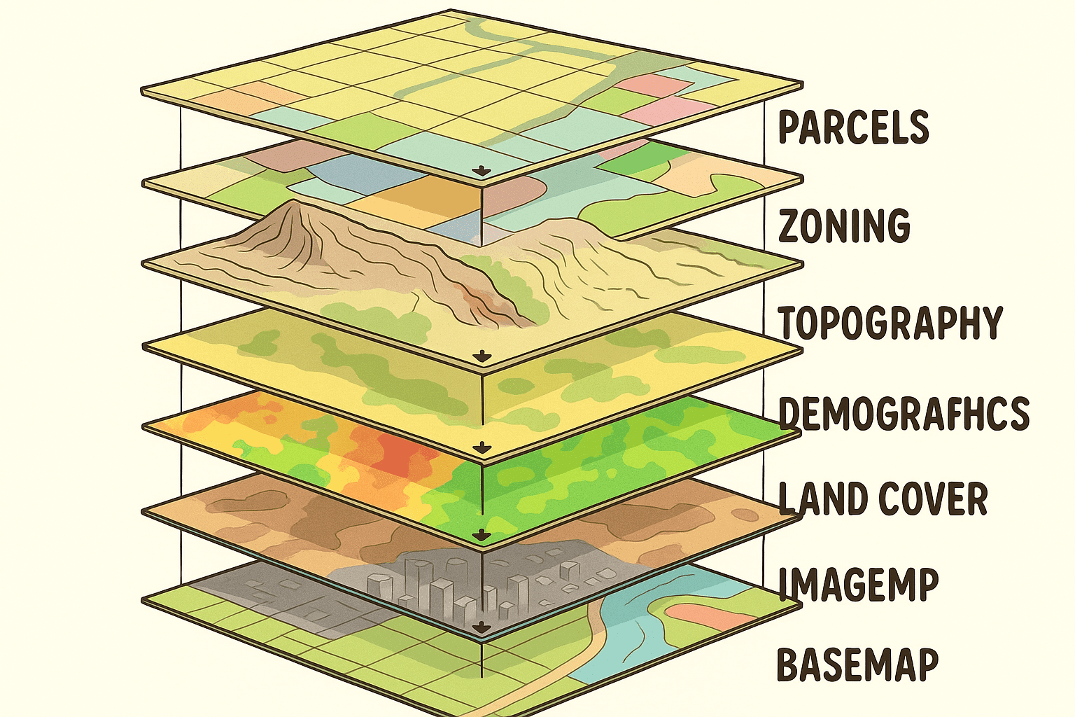
In this field, computer-based methods are used to display and examine geographic data and information tied to place. That work may draw from aerial images and elevation models, along with other spatial data used in research. At Marshall, students work with current technology such as GPS and GNSS tools, UAVs, ArcGIS, R, QGIS, LiDAR, Python, and spatial databases. From what I have seen in mapping systems over the years, that mix gives students a solid base in both theory and hands-on use.
Geospatial science connects naturally with many areas of study. Geography sits near the center, though environmental work, geology, history, engineering, urban planning, and criminal justice also rely on location-aware information. A large share of modern data contains a spatial element, which is why this area keeps expanding across science, management, and public service in the United States.
Students who want stronger career options often add GIScience training to their main course of study. At Marshall, learners from biology, environmental science, computer science, geology, health informatics, and forensics use this certificate path to build practical knowledge that supports future employment.
About Our GIScience Programs
| Program Option | Level | Description |
|---|---|---|
| Geography with a GIScience emphasis | Undergraduate bachelor's degree | A Geography degree path that builds geospatial skills through focused coursework and applied study. |
| Interdisciplinary minor or certificate | Undergraduate | An option for students in other majors who want formal GIScience training alongside their primary field. |
| Geospatial Information Science certificate | Graduate certificate | A shorter graduate option for students who want deeper technical preparation in geographic information system applications. |
Marshall University offers several ways to study this subject. Students can pursue a bachelor’s degree in Geography with a GIScience emphasis, or choose an interdisciplinary undergraduate minor or certificate. A graduate certificate in Geospatial Information Science is also available.
For undergraduates, the program creates a route into geospatial work through coursework that fits multiple disciplines. Graduate students can use the certificate to deepen technical ability and strengthen preparation for advanced research or specialized work in geographic information system applications.
The program is built to widen GIS study across different fields and help students apply those methods to real problems. It also supports technical training, experience before graduation through internships or work study, and preparation for either direct employment or graduate-level work.
- Study GIS in multiple disciplines and connect it to real applications
- Learn GIS methods that support analysis and problem solving
- Gain field experience before graduation through internships or work study
- Pair GIS applications with relevant computer science education
- Prepare for GIS employment or advanced academic work
Coursework and Degree Focus
Students in this area typically study core subjects tied to geographic information system work and spatial analysis. The curriculum usually starts with Geography foundations and mapping concepts, then moves into remote sensing, cartography, and database-focused work. As students advance, they often take applied classes in urban planning support, natural resource analysis, or project-based research that uses geographic data and information.
Advanced work may also include surveying methods, scripting for automation, or image interpretation with LiDAR and related tools. I looked at this like overlapping map layers - the technical pieces matter on their own, but they make more sense once students see how they connect in actual projects.
Degree Requirements and BS Details
This page points to a bachelor’s route in Geography with a GIScience emphasis, but it does not list the full BS degree requirements. A detailed plan would normally spell out required core courses, total credit hours, and any capstone or prerequisite sequence. It would also show which general education or elective requirements apply to the degree path.
Because those items are not presented here, the clearest takeaway is the structure that is shown: a Geography-based undergraduate program with a GIScience emphasis, plus minor and certificate options for students who want to add geospatial training to another major.
Specializations and Study Paths
No named specializations or formal tracks are listed on this page for the geospatial science degree. The study paths that are clearly identified are a GIScience emphasis within Geography, an interdisciplinary undergraduate minor or certificate, and a graduate certificate in Geospatial Information Science.
In practice, that gives students more than one way to build expertise. One path centers on a full undergraduate degree, while the other adds targeted geospatial training to an existing field of study.
Career Preparation in Geospatial Work
Students often ask a few direct questions early on. One is whether geospatial science is a hard major. In practice, it can be demanding because it blends science, technology, and interpretation of data. You need comfort with software and some technical problem solving, yet the work is usually easier to grasp once you see it like stacked map layers, where each layer adds context instead of confusion. In my experience, project-based learning helps a lot.
Another common question is what geospatial science actually includes. At the working level, it covers the capture, management, and analysis of information tied to location. That can involve GIS and remote sensing, along with related work in cartography or surveying, depending on the program and the job. It supports research into both human patterns and the natural resource systems around them, and it also serves applied fields such as sustainability and engineering.
Students also want to know what a geospatial job looks like day to day. A geospatial role usually involves collecting geographic data and information, checking quality, building maps, and interpreting spatial patterns for someone else’s decision process. In some settings that means support for urban planning or natural resource management. In others, it may lean toward public safety, infrastructure, or military analysis.
| Job Title | Primary Responsibilities | Typical Work Setting |
|---|---|---|
| GIS analyst | Build maps, manage spatial data, support analysis | Government offices or private employers |
| Cartographer | Design map products and present geographic information clearly | Planning groups or mapping teams |
| Remote sensing specialist | Interpret imagery and support land or resource analysis | Environmental or research settings |
| Planning technician | Assist with land-use data and planning documents | Urban planning departments |
| Survey support specialist | Handle location data and support field-based mapping tasks | Field operations or consulting groups |
| Geospatial developer | Work with software, databases, and spatial tools | Technology-focused teams |
As for jobs you can get with a geospatial science degree, the range is broader than many people expect. Some roles sit closer to field operations, while others focus on data management and software-heavy analysis.Geospatial careers tend to reward people who like practical problem solving and interdisciplinary work.
Geospatial careers tend to reward people who like practical problem solving and interdisciplinary work.
A strong first step toward becoming a GIS analyst is earning a degree in Geography or a related subject. That academic base helps students understand physical systems, cultural patterns, and the methods used to interpret spatial data. Without that foundation, software skills alone can feel like raw GPS points without a stable reference system.
After completing a degree, additional training in GIS tools and methods usually makes sense. Marshall supports this through GIS coursework and online learning resources, including Esri ArcGIS tutorials. In one typical study session, a student can spend an hour or two moving from basic map design into more advanced spatial analysis, which is often where the material starts to click.
Internships and early-career positions are also important because they add practical experience and professional contacts. Students can look for openings with government offices, consulting groups, or private employers that depend on geospatial analysis in regular operations.
Technical ability matters, though communication matters too. GIS analysts need to explain complex information in plain language and work effectively with colleagues or clients. That balance is a big part of long-term success in geospatial science, especially for students who want to turn undergraduate education into steady employment.


