
Airbus Leads German Team For Sovereign Space Isr Capability


Germany’s space industry has moved a step closer to an independent Earth observation and ISR system, with Airbus Defence and Space signing a Memorandum of Understanding with Rohde & Schwarz, constellr, Orbint and HPS. The agreement is aimed at building a satellite-based solution that gives government users access to sovereign intelligence and remote sensing data without relying on non-European infrastructure.
A Joint Push for Independent Earth Observation
Airbus will act as prime contractor and system integrator for the effort. The group combines five German companies with different strengths across space technology, payload integration and sensor-driven information systems. From what I’ve seen in geospatial programmes, that kind of setup matters because an Earth observation satellite project only works well when the data path lines up cleanly from orbit to end user.
The stated goal is to respond to rising public-sector demand for a full surveillance chain in space that remains under European control. In satellite technology, ISR means intelligence, surveillance and reconnaissance. In practice, that means satellites collect imagery or signals from orbit, move that data through ground systems, and turn it into usable intelligence for defence or security teams.
Earth observation satellites are the wider category behind that mission. They watch the planet to track environmental change or support mapping, and they are also used after floods or wildfires when fast imagery helps responders see what has changed on the ground.
How Airbus and Partners Describe the Program
“Europe has the talent, the technology, and the industrial base to build its own space intelligence infrastructure and the strategic imperative to do so," said Mike Schöllhorn, CEO of Airbus Defence and Space. "This consortium brings together five German companies whose capabilities are genuinely complementary. Together we can deliver a sovereign, end-to-end solution that no single company could offer alone.”
“Europe has the talent, the technology, and the industrial base to build its own space intelligence infrastructure and the strategic imperative to do so," said Mike Schöllhorn, CEO of Airbus Defence and Space. "This consortium brings together five German companies whose capabilities are genuinely complementary. Together we can deliver a sovereign, end-to-end solution that no single company could offer alone.”“This partnership demonstrates the value of combining the proven expertise of established players with fresh innovation and highly specialized emerging capabilities into operational value for our customers,” said Thomas Bohne, Vice President SIGINT / EW, Rohde & Schwarz. “Rohde & Schwarz has built its reputation on world-class RF technology and mission-critical signal intelligence capabilities. We are committed to working with innovative technology players who bring new perspectives and complementary expertise. Together, we can help shape a sovereign European ISR capability that is technologically strong, resilient, and independent.”
“This partnership demonstrates the value of combining the proven expertise of established players with fresh innovation and highly specialized emerging capabilities into operational value for our customers,” said Thomas Bohne, Vice President SIGINT / EW, Rohde & Schwarz. “Rohde & Schwarz has built its reputation on world-class RF technology and mission-critical signal intelligence capabilities. We are committed to working with innovative technology players who bring new perspectives and complementary expertise. Together, we can help shape a sovereign European ISR capability that is technologically strong, resilient, and independent.”
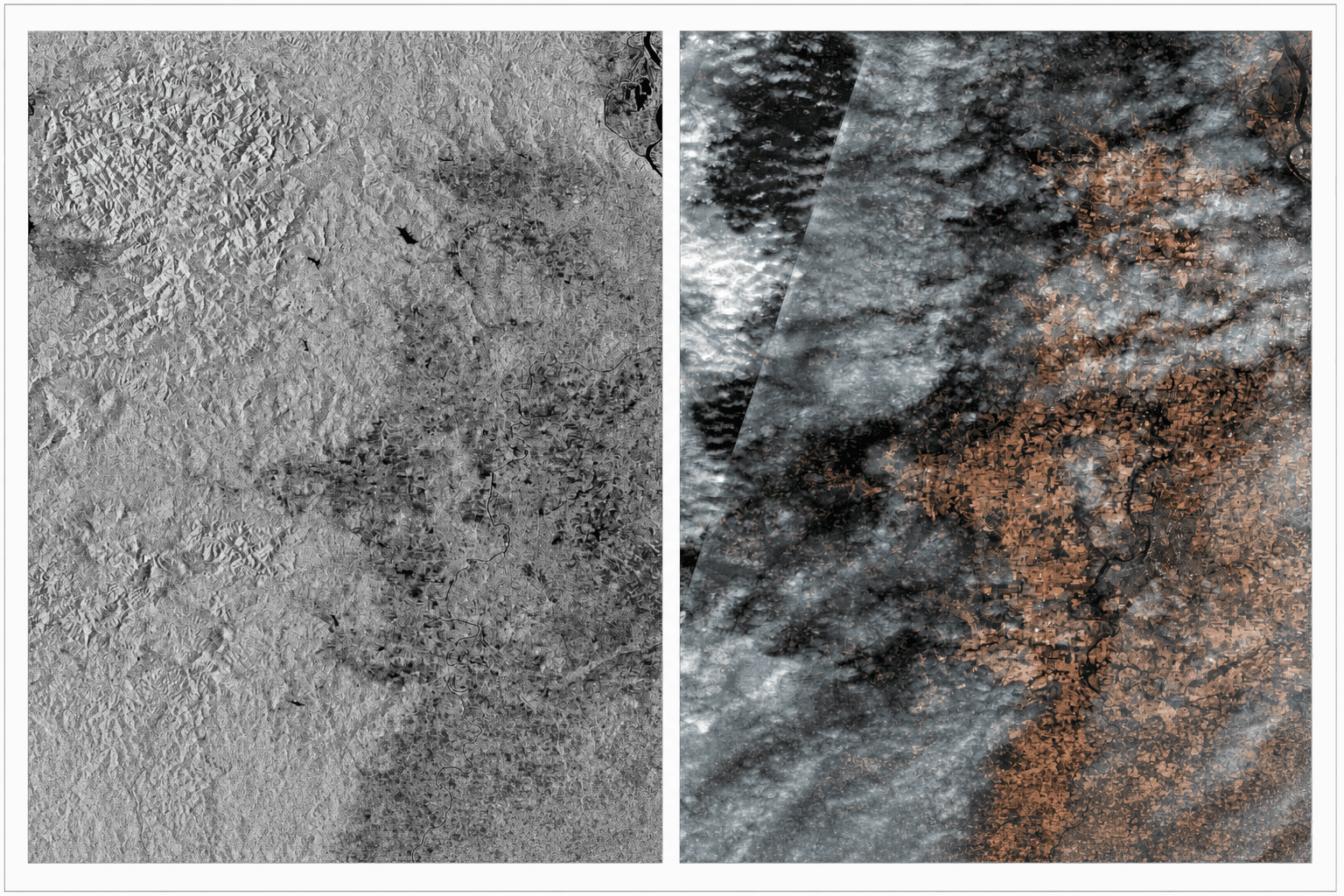
Thermal Infrared Fills a Key Gap
"This is a mission before it is a contract. We are joining this consortium because thermal infrared reconnaissance - the ability to detect operational activity, equipment state, and early-warning indicators that remain invisible to optical and radar sensors - is precisely where the ISR capability gap is greatest. We are proud to contribute that alongside Airbus, and to bring an already operational, sovereign German thermal ISR capability into a programme of this strategic importance", said Max Gulde, CEO and Co-Founder, constellr.
"This is a mission before it is a contract. We are joining this consortium because thermal infrared reconnaissance - the ability to detect operational activity, equipment state, and early-warning indicators that remain invisible to optical and radar sensors - is precisely where the ISR capability gap is greatest. We are proud to contribute that alongside Airbus, and to bring an already operational, sovereign German thermal ISR capability into a programme of this strategic importance", said Max Gulde, CEO and Co-Founder, constellr.
That point stands out. Infrared observation can reveal activity on Earth that a standard optical sensor or even synthetic-aperture radar may miss under certain conditions. In mapping terms, I read it like adding another layer to a satellite imagery stack. The more complete the layer set, the better the operational picture.
Different imagery types fill different roles. Optical imagery gives a familiar visual view, infrared highlights heat patterns, and SAR uses radar to image the surface through cloud cover and in darkness. Multispectral and hyperspectral systems go further by separating reflected energy into finer bands, which helps analysts distinguish materials or stressed vegetation with more precision.
For ISR work, low Earth orbit is usually the practical choice because it supports higher-resolution collection and faster revisit times than more distant orbits. The trade-off is narrower coverage per pass, but for surveillance missions the closer vantage point usually matters more.
Access to Earth observation data depends on the mission. Some datasets are released through public space agencies, while other feeds are sold through commercial platforms under licensing terms. Government users typically work through contracted services or direct tasking arrangements when they need controlled access and faster delivery.
Satellite-based Earth observation also feeds decision-making well beyond defence. It helps public agencies compare land change over time, and it gives businesses a current view of assets or disruption zones. I looked at this the same way I would read overlapping map layers - the value comes from turning raw pixels into signals that support an actual choice.
The wider market around Earth observation is also growing, with demand driven by defence use and commercial analytics. Major players include large aerospace primes and specialist satellite operators, though this article stays focused on the German consortium itself rather than the broader market ranking.
The partnership suggests a broader move in European aerospace toward tighter control over military-grade data acquisition in low Earth orbit, with Airbus positioning the program as a practical route to sovereign reconnaissance from space to usable information.


