This article brought to you by Eos Positioning Systems.
Today’s utilities are increasingly adopting high-accuracy mobile mapping solutions. The importance of accurate infrastructure maps has never been more widely understood. As a result, it seems every entity from cities, counties and other government bodies to utilities of all types are putting greater emphasis on, and investment in, mapping assets (old and new) with higher accuracy.
Meanwhile, as demand for accuracy has soared, the technology required to perform high-accuracy mapping has become even more affordable, accurate, and accessible. Esri ArcGIS licenses have become more flexible, for instance, so organizations pay for only the user types they use. Other mobile data collection providers have created apps specialized for very specific industry applications. Mobile tablets like the iPad have changed the game in terms of usability, interface, and widespread use of smart devices. And external GNSS receivers like the device-agnostic Arrow Gold have democratized access to accuracy among even the tightest budgets. To put it simply, high-accuracy mobile mapping solutions are no longer an outlier. They are becoming the expectation.
Looking Beyond the Digital Twin
With highly accurate “digital twins” and 3D maps of cities solidifying themselves as the new-now of GIS, the industry is realizing it can do even more — by integrating even more data into these maps. Not only can maps now represent the real world in accurate XYZ. But they can also integrate increasing amounts and types of critical data about assets’ past, present and — thanks to analytical insights — potential futures.
One example of this is the growing demand for the integration of third-party sensor data and metadata into GIS maps. Imagine as a utility GIS analyst you could pull up with confidence not just the location of a buried asset, but also its origin story, work-order history, and even perhaps its current status. Is it operational? Is it leaking? Is it involved with an emergency event? If it is buried, where and how deep in the ground is it exactly?
All of these questions can now be answered — just by looking at a map.
So how do we get there?
Integrating Sensor and Other Third-Party Instrument Data Into Your GIS Maps
Integrating support for existing third-party sensors into mobile mapping solutions is the first step. Doing this allows nearly infinite types of data and metadata to be captured alongside the XYZ of an asset, and transferred in near real-time to a GIS professional in the office. This person, in turn, can immediately process the data and make it available to key decision-makers. Team-specific, functional maps can also be distributed to departments that can use the information to improve customer service, operational efficiencies, and the general well-being of utility staff. Imagine a repository of “living” maps replete with rich, reliable, and targeted data. Finally, decision-makers can have a complete set of information upon which they can make strong, defensible, visual decisions.
But really: How do we get there?
The Migraine of Older Mapping Techniques
Some of today’s forward-thinking utilities are already piloting field-data-collection workflows that combine …
- Map-based data collection software
- Consumer-friendly mobile devices
- External GNSS receivers for higher accuracy
- Third party sensor information
… into a single, non-cumbersome data-collection kit.
Taking the First Step
The first step is really to take a look at any existing technology investments (hardware, software) to see if you have the required components to deploy high-accuracy sensor mapping. Industry-leaders such as Esri (for GIS apps), Apple (for mobile tablets), and Eos Positioning Systems (for GNSS receivers) are already providing an access point. Then, it’s important to determine: Which type of third-party sensor data do you need to include in your maps?
Within recent years many gas and water utilities, for instance, have focused specifically on incorporating data from underground utility locators into their mobile-mapping solutions. Several utilities across the United States are piloting projects that allow them to map the accurate location and associated metadata of existing buried assets directly into ArcGIS web maps.
So, what are they doing differently than the rest? Let’s take a look at what they aren’t doing any more …
Legacy Mapping Choices
Historically, utilities have been challenged to create accurate maps for existing buried assets. Yes, many paper maps were digitized. But often the information contained in them was unreliable, incomplete, or both. Not to mention, paper maps lack rich 3D elevation data.
An alternative was to pay the sky-high price of digging boreholes, mapping the exposed assets, and inferring the remaining locations from there.
Yet another option was to capitalize on 811 calls by sending one team to locate and mark the buried assets (with flags or spray paint). Then dispatch another team to GPS the marks. Then devote yet another person in the office to the task of conflating the two (or more) datasets into a single geodatabase. Then cross one’s fingers the results were correct. We at least know these results failed to include accurate depth below cover, since just the surface was mapped.
For most utilities the cost of, and lack of confidence in, these results render the above options less than desirable.
So, what are these forward-thinking utilities using?
A Sensible Way to Map Sensor Data
Imagine a gas utility whose infrastructure is mostly subterranean. These buried assets were installed over the years. Paper as-builts exist, but their quality varies. Once digitized, these maps too often fail to line up with the GIS. So, GIS teams and field crews make do, updating what they can, when they can. They know upcoming regulations will soon require them to maintain a spatially accurate database. They know the data is inaccurate.
Imagine now that this utility hears about a new solution for mapping underground assets with centimeter accuracy to their GIS. They decide to perform a pilot project.
A field crew member named John Doe responds to a typical 811 ticket. John goes out to the field with his utility locator, locates the asset and simply spray-paints the ground. His work is done. That’s good news. But what if John also had a GNSS receiver and cell phone mounted on his locator? John could then quickly launch his GIS map, turn on his GNSS receiver, and push the exact same button on his locator. Within a few seconds, John has also mapped the accurate 3D location of the buried asset — with all its GNSS metadata and locator metadata — and sent this directly to an ArcGIS web map available in the office. In the click of a button, he has both located and mapped the asset. The GIS manager in the office can view, process, and use this data instantly.
What would they gain?
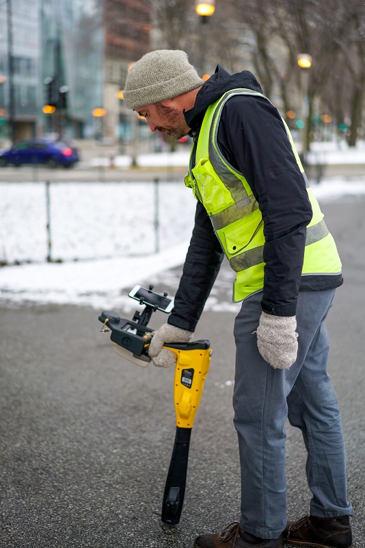
Collecting data with Eos Locate in Wheaton, Illinois
Benefits to Be Gained
If this utility continues to treat all 811 calls like this, over time the benefits could be endless:
- They will learn the exact location of all buried assets.
- If the ground is ever paved over, the GNSS metadata containing absolute elevation allow them to recalculate the depth below cover.
- Crews responding to emergency events can quickly navigate back to that exact asset location.
- Customers spend less time without service.
- The utility exhausts less labor and fewer resources in the field.
- Response times and related statistics improve.
- The extent of any threat, such as a gas or water leak, reduces as response time improves.
- Employee satisfaction increases. Well equipped employees just perform better.
- Complying with upcoming regulations becomes easier, thanks to all the data being accurately captured, centrally housed, and geospatially enabled.
- All future field interventions, whether scheduled or not, become faster, less expensive, and easier to perform.
- If the utility ever wishes to adopt augmented-reality field solutions, market-leading options suddenly present themselves as realistic, practical, and viable, because they have accurate data to input into AR systems.
- There’s a lot fewer holes in the field.
All of this is gained because John not only found stuff, but also mapped it.
These kinds of results can justify an entire organization shifting to high-accuracy, sensor-enabled field data collection.
And this is just one example of sensor integration.
Exploring the Landscape of Such Solutions Today
This example of underground utility locating directly to GIS is possible today with solutions like Eos Locate™, the first underground mapping solution for ArcGIS. Eos Locate™ combines industry-dominant technologies such as Esri ArcGIS, Apple iOS devices, and Eos Arrow Series® GNSS receivers with a variety of utility locator models.
We are just starting to truly understand the full impact of such sensor integrations.

Eos Locate data in ArcGIS Field Maps
Introducing More Solutions: Get to Know the Eos Bridge™ (a Bluetooth® Connector for Legacy Sensors)
This is why location companies like Eos Positioning Systems have begun to support additional third-party sensor integrations. This year, Eos released the Eos Bridge™, a new product which transforms third-party sensors into Bluetooth® streaming devices. Consider the sheer number of legacy instruments in the field today that could gain a second life by being able to stream their rich content to a web map. Yes, solutions for utility locators and laser rangefinders already exist. But imagine the capital costs that could be saved by integrating other sensors. Imagine the number of legacy instruments that are suddenly future-proof.
This is not a far-away reality. More sensors are being integrated today.

What Comes Next?
Solutions like the Eos Locate™ sensor integration come about as the result of utilities, local governments, and other location-technology users voicing their needs.
To learn more about Eos Positioning Systems and products like the Eos Bridge™ Bluetooth® connector for legacy sensors, as well as new GNSS receiver models that are capable of interfacing with sensors, visit www.eos-gnss.com.