This article brought to you by Airbus, Intelligence - Resolution, Geolocation, Tasking, New Bands Make the Difference
With the 2021 launch and commissioning of the first two Pléiades Neo satellites, Airbus, Intelligence delivered on its promise of providing the highest native spatial resolution Earth observation satellite imagery to the commercial market. And in the coming months, Airbus will double down on its commitment to building the most powerful and versatile remote sensing constellation with the launch of two additional Pléiades Neo satellites.
Much has been said about the Pléiades Neo’s 30cm spatial resolution, and for good reason. Best on the commercial market today, this resolving power expands the applications of satellite imagery into numerous surveying and mapping sectors where detecting, identifying, and measuring small objects is paramount.

Pléiades Neo 30cm resolution image over Sydney airport in Australia.
Often lost in the Pléiades Neo discussions, however, are the other significant upgrades brought to the market. Most importantly, each of the four identical satellites offers a previously unmatched geolocation accuracy and image consistency, which in many ways is just as crucial to mapping applications as spatial detail.
The uncorrected imagery (Primary) has a native accuracy of 3.5 meters (m) CE90. This means that 90 percent of the points in the image will fall within 3.5m horizontally of their absolute location on the Earth’s surface. In addition, the orthorectified products sold by Airbus boast a stunning 5m CE90 accuracy worldwide.
The new constellation has ushered in an era of rapid customer tasking that makes near real-time data delivery a reality. But that’s not all; the four Pléiades Neo satellites capture image data with enhanced multispectral capacities now including the Deep Blue and Red Edge bands. The combination of spatial resolution, geolocation accuracy, new bands, and fast tasking makes the constellation the most versatile surveying and mapping satellites ever built for commercial use.
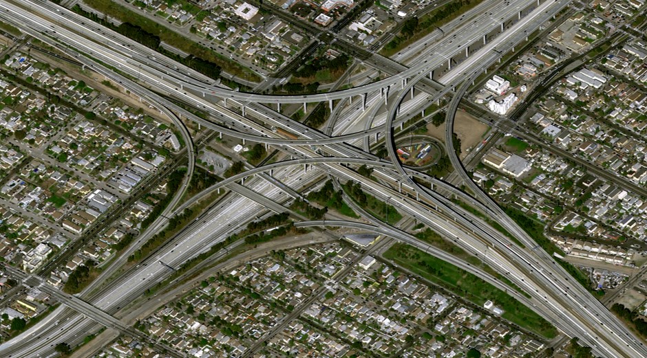
Pléiades Neo 30cm native resolution imagery over an intersection in Los Angeles.
Completing the Constellation
The four-satellite Pléiades Neo constellation is the significantly upgraded follow-on to the high-resolution Pléiades 1A and 1B satellites launched by Airbus in 2011 and 2012. For this reason, the first two new satellites are officially called Pléiades Neo 3 and 4. They will be joined in orbit in November by Pléiades Neo 5 and 6, which are scheduled for launch aboard a Vega-C rocket from Kourou, French Guiana.
The four Pléiades Neo satellites each capture 30cm panchromatic and 1.2m multispectral image data at 14km swath widths. Each can collect up to 500,000 square kilometers (km2) per day and up to 7,500 km2 in a single pass. Together, the four will capture 2 million km2 in a single day.
The satellites are extremely agile which gives them the ability to slew in orbit to capture imagery at oblique angles to either side. This expands the frequency with which they can collect “revisit” imagery over the same geographic area on Earth’s surface. By itself, each satellite has daily revisit, and the two in orbit increase this cycle to twice daily. When the constellation is complete, nearly any location on the globe can be imaged at least two times a day, and sometimes three times, depending on viewing angles and latitude. This enables users to monitor rapidly evolving events such as floods, fires, and storms
Designed with Accuracy and Resolution in Mind
Airbus designed the Pléiades Neo satellites and processing systems from the ground up to capture and deliver the highest quality commercial imagery possible. From the perspective of nearly any geospatial application, especially feature mapping, the accuracy of pixel geolocation is equally important to the pixel resolution. In other words, knowing precisely where a feature is located on Earth is just as crucial as identifying it.
Accurate geolocation starts on the satellites where onboard sensors, star trackers, and inertial measurement units ensure the spacecraft knows where it is when each image is captured. This telemetry data, along with a precise model of the imaging sensor geometry, is an important input for processing the raw imagery and achieving a high level of location accuracy.
With minimal additional processing, Airbus sells this data, called a Primary product, to customers who perform their own geometric processing. As noted above, the advertised native planimetric accuracy is 3.5m CE90, although most data sets are achieving better results.
In addition, a superior 5m geolocation accuracy is achieved worldwide in the Orthorectified image products where geometric distortions have been removed in a processing workflow developed specifically for the era of Pléiades Neo.
To accomplish this, Airbus created a new worldwide database of highly accurate 3D ground control points, called Space Reference Points (SRPs), from archived SPOT 6 and 7 multi-view satellite image stacks acquired over decades of SPOT operations.
In addition to the SRPs, the Airbus geometric processing workflow uses elevation models from the Airbus WorldDEM4Ortho product database to reach the 5m planimetric accuracy. The Digital Terrain Models and Digital Surface Models from the WorldDEM4Ortho database, which was generated from the Airbus TerraSAR-X and TanDEM-X satellite radar missions, delivers a sub-meter vertical accuracy in the orthorectified products.
It is important to note that Airbus now uses the SRP/WorldDEM4Ortho geometric processing workflow to generate orthorectified image products for its Pléiades Neo, Pléiades 1A/1B, SPOT 6/7, and Vision 1 Earth observation satellites. This means all Airbus optical orthoimages are aligned to the same reference system and are fully compatible with each other for large, multi-sensor analysis projects, such as time-series change detection. Additionally, inter-sensor compatibility is a necessity for analysis involving Artificial Intelligence.

From left to right: 1.5m, 50cm and 30m data from the Airbus Constellation over National Stadium in Beijing, China.
Available and Accessible Now
Pléiades Neo 3 and 4 have been commercially operational since late 2021, and their combination of spatial detail, geolocation accuracy, and frequent revisit have made them an instant hit for a variety of mapping and monitoring applications in Defense/Intelligence, Energy, Agriculture/Forestry, Civil Engineering, and Maritime sectors.
Unprecedented user accessibility has also impacted the enthusiasm. Satellite tasking can be scheduled directly by the customer through the Airbus OneAtlas platform in as little as 25 minutes before a satellite passes over an area of interest. An entirely new production workflow can downlink the data from a Pléiades Neo satellite and deliver a finished product to the customer within as little as two hours of order placement – the first truly near real-time imaging capability on the market today.
Contributing to this broad appeal are the advanced multispectral capabilities in the Visible Red, Green, Blue, and Near Infrared portions of the spectrum – as well as two new bands. The new Deep Blue band (400-450 nm) penetrates the water column to deliver insights related to depth and water quality in the near-shore ocean environment, as well as in freshwater lakes, rivers, and streams. Uses have developed hydrologic and bathymetric applications in the coastal zones, including mapping seafloor relief in shallow areas.
The Red Edge band (620-690 nm) is being leveraged to detect subtle vegetative stress in applications related to agriculture and forestry. Sensitive to chlorophyll production in green plants, this wavelength enables users to identify problems in vegetation, such as infestation, poor irrigation, and inadequate fertilization. Red Edge data reveals the stress early in the growth cycle before the human sees it, often before the damage is permanent. The spatial detail of Pléiades Neo data allows farmers and foresters to find vegetative problems in individual plants and trees.

Pléiades Neo 30cm resolution data showing the leaf area index and leaf chlorophyll content of fields over Merida, Mexico.
One final factor that has favored the new constellation in the marketplace is its ownership status. Fully owned and operated by Airbus, the satellites are 100% dedicated to commercial availability.
Learn more about Pléiades Neo 30cm resolution imagery here.