Loc8 Codes were released for Ireland (North and South) on July 12, 2010 at a launch in the Science Gallery, Trinity College, Dublin by Charley Boorman, the modern day adventurer. A Loc8 Code is a digital address code designed as a smarter form of postcode for use with modern location based technologies. Every Loc8 Code defines a position to an accuracy of +/-6 meters, allowing a vehicle or pedestrian to navigate to within visual distance of the desired destination.
 |
Garmin assisted in field testing the technology and has now released it as standard on all its popular consumer sat navs (satellite navigation systems). Loc8 Codes will be available to all manufacturers and developers early in 2011, with iPhone apps to be released shortly.
In this age of technology, being a navigator is no longer the preserve of professional mariners, aviators or explorers - everyone can be a navigator nowadays using sat navs and all other GPS enabled devices. But the means by which destinations are entered into these devices has not kept up with the technology. In Ireland, there has been a particular problem as a result of the nature of the traditional addressing system. Unlike other countries, 40% of the population lives outside urban centers and because of related historical townland based address definitions, up to 40% of addresses are non-unique. In other words, someone else has exactly the same address, only differentiated by the name of the occupier. This particular issue, coupled with variations in spelling, both Irish and English language versions being used, and postal versus actual physical addresses, has meant that entering an address-based destination into navigation devices is troublesome and less than precise. NAVTEQ first released data for Ireland in 2005 and from the outset supported townland related addresses, but many townland names are repeated and even navigating to the correct one will just get you to the area at which you will then have to set about finding the correct property. Vanity addresses are also prominent in Ireland, where property owners vary their address to suggest that it is in a more "desirable' neighborhood.
It is for all these reasons that commercial users and tourists using navigation devices in Ireland have had less than satisfying results. This probably is a large contributor to the fact that in Ireland penetration of sat navs among vehicle owners was only at 50% of the European average up to 2009.
So it was against this background that GPS Ireland, GPS consultants in Ireland, set about finding a solution. While many these days are navigators, few are trained to understand latitude and longitude in their multiple formats and therefore offering geographic coordinates as a solution to precise addressing was considered less than satisfactory. In Loc8 tests where all of decimal degrees, degrees-minutes-decimals of minutes and degrees-minutes and seconds were supported as entry formats, a very large percentage made a destination in one format "fit' into an entry point in another format. This showed potential for catastrophic errors, a major problem if emergency service personnel were to use them. Not to mention the fact that lat/long is now available from many online and off line services in multiple formats and with multiple related position accuracies.
 |
This is where the way location is expressed has not kept up with advances in location technology. Ireland does not have postcodes and various attempts to resolve this at government level over the last five years have been unsuccessful to date. But postcodes are a 1960's solution to a mail sorting problem that pre-dates GIS, GPS and LBS, route and load optimization technologies and a plethora of mail sorting and scanning solutions including optical character recognition (OCR), which all would probably dictate that even the UK postcode system might have been designed differently if they were available then.
The UK system requires every road to have a name and every property a number, which has not been universally achieved, not least in Northern Ireland where postcodes do not always define anymore than just a general area. Northern Ireland's property address system is historically similar to the Republic's, that is, townland based and often without road names or property numbers.
It is universally recognized on the island that asking people to change their addresses would be less than successful. Furthermore, traditional postcodes only define properties. Vehicles, pedestrians and tourists routinely wish to navigate to non-properties, which a traditional postcode cannot accommodate - taxi ranks, bus stops, grain silos, masts, accident and breakdown sites, entrances to industrial sites, infrastructure at outdoor festivals or sporting events, or even a specific entrance to major indoor events!! It is estimated that there are well in excess of 300,000 such destination points in daily use in Ireland, many of which are not fixed. One could argue that most could be entered into a point of interest (POI) database and loaded to navigation devices, but it would not be physically possible to cover all and to allow for those, such as breakdown sites, which obviously change.
 |
So in designing Loc8 Codes, all of these factors had to be taken into account. Of course, if location information is being shared electronically then the lat/long will suffice, but no matter how technologically advanced we become, humans will always need to communicate location to each other in traditional ways, such as verbally, in writing, e-mail, etc. We have been working with these issues over the nearly four years of design and field testing since late 2006. This is what we have developed to address this significant need. Loc8 Codes are an eight character alphanumeric code, mathematically related to geographic coordinates which will get the user to within visual recognition distance of any destination and require absolutely no training to use correctly. Loc8 Codes are uniquely implemented on devices without the need for an address database, the programming requirement being no more than that related to adding another coordinate system to a navigation application.
Key features which differentiate Loc8 Codes from anything else in use globally are as follows:
- A checker code which checks a user-entered code and prompts error correction
- Key features which ensure that a Loc8 Code can be easily validated
- Key features which allow software or scanning devices to robustly pick out a Loc8 Code in the middle of many other items of text, addresses, reference numbers and codes
- It is language independent
- It does not require an existing address to be changed
- It can be used to identify non-property based destinations
- In a connected scenario the Loc8 Code can identify other key information to help guide the user to the destination
- There is no requirement to change property codes as densification occurs, as is normal with traditional postcodes
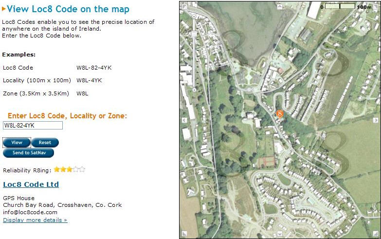
- A Loc8 Code is formatted in such a way as to allow it to be added to a standard URL to pinpoint the location on a Web map - enter www.loc8code.com/W8L-82-4YK to see its location on Loc8's Web mapping service
The Loc8 Code for Loc8's offices in Cork is Cork W8L-82-4YK, where the W8L is a zone and the W8L-4YK is the locality including the checker character. The eight characters compare favorably to the UK postcode, which frequently is seven characters and has to be used in conjunction with a property number to identify a specific property, thereby being on the order of 9-10 characters long. A Loc8 Code is finite at eight characters, it never has to change as new building occurs, and it will get you to the door even if a property number does not exist!
Loc8 Codes, at this point in their evolution (five months since launch), are elective; people generate them for their own purposes. A Loc8 Code is generated using a Web mapping service. Google mapping does not, as of yet, deliver consistently high resolution mapping across all of Ireland and errors in excess of 30 meters in rectification do occur, and therefore, Loc8 uses Ordnance Survey Mapping instead. Mapping of scales down to 1:1,000 from both OSi and OSNI (Land and Property Services) covering the whole island are both delivered together from one server in the Loc8 Code service. Various processes used allow quality indicators to be associated with codes, including whether they are genuine properties or not, and these are very useful in Web retail/courier related services to prevent fraud and ensure timely delivery.
It is calculated that a Loc8 Code will allow couriers and other logistic organizations involved in daily multidrop endeavors to save in excess of 15% in annual fuel costs and allow them to offer time based premium services. In the near future, collaboration with existing address database management services will see Loc8 Codes being "ready made' for every property with the mapping service just being used to correct errors, resolve non-uniqueness, add new properties and support codes for non-property destinations.
Loc8 Codes are already seen on the websites of many businesses including hotels and B&Bs. Services for Web retailers/couriers, financial institutions, utility companies, emergency services and tourist resources are all ready for roll out during 2011.
Loc8 Codes are currently being adapted for other countries. Specific versions for city based activities around the world are in development also. Loc8 Codes even have a use where an existing postcode system is already in place, especially for non-property based navigation!