The Galapagos Islands are part of the Republic of
Ecuador, and are located in the Pacific Ocean approximately 1,000-km
from mainland Ecuador. Nearly 97% of the total land area of the islands
is designated as National Park, and the remaining 3% is a colonized
zone with urban and farm areas. In the archipelago, three primary
subsystems exist: Terrestrial Park, Marine Reserve and Human Use Areas.
These subsystems are interdependent and any alteration of one subsystem
has a profound effect on the others. Interactions among these
subsystems have immense consequences for resource conservation,
development and system dynamics. For instance, invasive plant species
threaten native and endemic flora and fauna and cause a loss of
biodiversity and ecological services, which are linked to human
occupation, settlement patterns, farm abandonment and alternate
household livelihood strategies. Exotic species are, relative to the
number of species they endanger, the least studied threat to
biodiversity (Lawler et al. 2006).
Free of humans and predators for almost all of its history, these "Enchanted Islands have developed some of the most unique life forms on the planet, highly adapted to their harsh surroundings and living in ecological isolation from the rest of the world. It was not until Charles Darwin's famous visit in 1835, which helped inspire the theory of evolution by natural selection, that this archipelago began to receive international recognition. In 1959, the Galapagos National Park was formed, and in 1973, the archipelago was incorporated as the 22nd province of Ecuador. UNESCO (United Nations Educational, Scientific, and Cultural Organization) designated the Galapagos as a World Heritage Site in 1978, a designation to honor the "magnificent and unique natural features of the Galapagos and to ensure their conservation for future generations. These islands were further deemed a Biosphere Reserve in 1987, and the Galapagos Marine Reserve was created in 2001. In 1998 the Ecuadorian government passed the Special Law for Galapagos, which was designed to "protect and conserve the marine and terrestrial resources of the Islands and this law resulted in the formation of the Marine Reserve. The Galapagos archipelago encompasses 19 large islands (4 of which have human populations) and 200 small islands and rocks totaling approximately 8,010 sq. km. dispersed throughout an area of 70,000 sq. km. The Galapagos Islands are world renowned for their scientific importance, as exemplified by the giant tortoises, marine iguanas and Darwin finches whose existence vividly illustrate the mechanisms of evolution.
Beginning in the 1970's, the Galapagos Islands began to draw thousands of new residents, attracted by the promise of lucrative opportunities linked to the islands' rich marine and terrestrial ecosystems, and employment opportunities in construction, fisheries and tourism. Development of the tourism industry and a boom in fishing has resulted in the growth of the local population from nearly 10,000 in 1990 to nearly 25,000 residents in 2006. In addition to settlement and population in-migration pressures on the Islands, the number of tourist visitors has increased from about 41,000 in 1990 to nearly 125,000 in 2006.
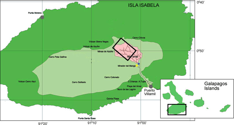
During the past two decades, dramatic social and ecological changes have occurred in the terrestrial and marine ecosystems of the Galapagos that have threatened the ecological resilience and survival of this fragile ecosystem. Chief among these threats has been the growth of the human population and the introduction of invasive flora and fauna that is replacing native and endemic species at an alarming rate. The basic intent of this project was to describe how hyper-spatial QuickBird satellite data have been merged with hyper-spectral Hyperion satellite data to better characterize the composition and spatial pattern of guava (Psidium guajava), an important and widespread invasive plant species that is altering the ecology and land use/land cover patterns of fragile environments in the Galapagos archipelago. Results from a study conducted on Isabela Island are described that have implications for control and eradication of invasive plants in fragile environments.
Invasive Plants in the Galapagos Islands
Initially welcomed by people for their fruit, wood and medicines, invasive species diminish the arable land, have become a constant source of expense and frustration to local farmers, and replace native and endemic plant species. To the fragile ecosystem of the Galapagos, invasive plants change the biological diversity, degrade ecological services, reduce the number of endemic plants, especially in the highlands, change communities of grasslands to forests, modify ecological processes, and compete with other species. It is estimated that at least 37 species (Tye 2002) are considered highly invasive and require immediate control, and that 640 plant species (Tye 2002) have invaded the Galapagos ecosystems.
Guava is a shrub or small tree widely cultivated for its edible fruit (Ellshoff et al. 1995). In the Galapagos, it is considered a transformer species (Tye et al. 2002), an invasive species that changes "the character, condition, form, or nature of ecosystems over substantial areas relative to the extent of that ecosystem (Richardson et al. 2000). Guava generally thrives in pastures and other grasslands, roadsides, cropland and other disturbed areas, forming dense thickets that prevent regeneration of native vegetation and reduce species richness. In the Galapagos Islands, the species can also invade natural forests (Binggeli et al. 1998). Both the high rainfall associated with El Niño events as well as fires are thought to have hastened its spread (Tye 2001).
Satellite Technology of Invasive Plants
Using satellite images and field data collected during the spring and summer of 2006 for a test area on Isabela Island (Figure 1), the composition and spatial structure of guava was examined through the following remote sensing and image processing approaches: (1) hyper-spatial and multi-spectral QuickBird data were classified using a pixel-based approach, and (2) Hyperion hyper-spectral data were used to examine the spectral characteristics of guava, and to link that knowledge to the classified QuickBird data (2.44 x 2.44-m) to spectrally "unmix the 30 x 30-m Hyperion data into the fraction or percentage of guava within each 30-m pixel using a linear modeling approach.
QuickBird collects data for a 20 to 40-km swath using a panchromatic band and four visible/near-infrared bands. The panchromatic band (0.45 – 0.90 micrometers) has a pixel resolution of 0.61 x 0.61 m, whereas the multispectral bands (ranging from 0.45 – 0.89 micrometers) have a 2.44 x 2.44-m spatial resolution. In this research, we used the multi-spectral data characterized at the coarser spatial resolution. The QuickBird data used in this analysis were collected on 22 October 2004.
Hyperion collects 220 unique spectral channels ranging from 0.357 to 2.576 micrometers with a 10-nm bandwidth and a spatial resolution of 30 x 30-m for all channels. The standard scene width is 7.7-km, and the standard scene length is 42-km. The Hyperion data used in this analysis were collected on 14 June 2002. Both the QuickBird and the Hyperion data sets were acquired by CLIRSEN, the Ecuadorian remote sensing and land use/land cover agency in Quito.
Mixture modeling or "unmixing refers to additive combinations of several diverse materials, such as land use/cover types that occur in patterns too fine to be resolved at the resolutions of the sensors (Song 2005). As long as the radiation from component patches remains separate until it reaches the sensor, it is possible to estimate fractions of component surfaces from the observed pixel brightness. Spectral unmixing is devoted to extracting pure spectra from the complex composites of spectra that, by necessity, form each image. The process involves the use of "endmembers, defined as the pure pixels that contribute to the varied mixtures of pixels (Adams et al. 1995).
Linear Mixture Modeling (LMM) was applied to Hyperion data using the classified, high spatial resolution QuickBird images. Although the practical strength of mixture modeling is its capacity to classify at the sub-pixel level when high resolution images are not available, in this case, mixture modeling was applied to hyper-spectral Hyperion data using endmembers derived through the use of the classified hyper-spatial QuickBird data. Due to the difficulty of obtaining field (or laboratory) measures, a number of applications use image-based endmembers. Endmembers included forest, guava, bare soil and pasture/cropland.
An unsupervised clustering algorithm (i.e. ISODATA) was used for an initial classification of the Hyperion data to better understand the spectral dimensionality and information content of the scene. The classification effectively distinguished clouds, shadows and volcanic lava from other land cover types, such as vegetation, pasture and bare soil. A mask was generated that represented the clouds, shadows and volcanic lava classes, so that vegetated areas could be accentuated in subsequent processing. The pixel-based classification of the QuickBird image was rescaled to a 30-m spatial resolution to provide a proportional map of endmembers that could be co-registered to the Hyperion data. A Minimum Noise Fraction (MNF) was used to further reduce the spectral dimensionality of the Hyperion data by eliminating spectral noise in the high spectral resolution data cube (Green et al. 1988). The Pixel Purity Index (PPI), after Boardman et al. (1993), was combined with the use and interpretation of scatter-plots of MNF to characterize the relative abundance of guava across the study area and to determine that a four endmember model (i.e., guava, pasture, bare soil and transitional vegetation) could sufficiently distinguish guava from other primary cover-types.
Results and Conclusions
Figure 2 shows the typical "salt and pepper appearance of pixel-based spectral classifications of high spatial resolution imagery, somewhat obscuring the more defined pattern of land use/land cover evident on the QuickBird imagery for the agricultural zone. The overall distribution of guava, however, is readily apparent, with a large area of invasion in the southwest corner of the study area, scattered patches of invasion across the agricultural zone, and dispersed, smaller patches of invasion along the transition zone located along the border of the Park. Figure 3 shows the results of the linear mixture modeling classification of guava derived through the decomposition of the Hyperion data into fractions or percentages of guava at the 30-m pixel. The density measures of guava derived at the pixel-level were grouped into density classes and mapped at 10% intervals for ease of interpretation.
This research has several implications for environmental management in the study area: (1) interpretation of the products generated using the QuickBird and Hyperion data (verified using ground control data and direct observation) and the various methods used to examine them suggests a high degree of certainty in the characterization of the location, density and spatial structure of guava across the study area classified using the hyper-spatial data; (2) the sub-pixel classifications of hyper-spectral data were able to distinguish the "soft edges or transition zones of the guava invasion that proceeded from the older agricultural areas and extended to the edges of the Galapagos National Park. The severity, spatial extent and rate of spread of the guava invasion across the broader landscape is likely affected by age of establishment of the guava source areas and land management strategies implemented on the farm and on adjacent farms. The ecological-spatial gradient of guava across the landscape has implications for control and/or eradication as large patches and moderately-sized patches that have coalesced together create a negative feedback on the landscape as animal dispersal of seed and the emergence of new seedlings serve to "choke the landscape and further debilitate the farm, thereby, offering new challenges to control and/or eradication.
References Cited
Free of humans and predators for almost all of its history, these "Enchanted Islands have developed some of the most unique life forms on the planet, highly adapted to their harsh surroundings and living in ecological isolation from the rest of the world. It was not until Charles Darwin's famous visit in 1835, which helped inspire the theory of evolution by natural selection, that this archipelago began to receive international recognition. In 1959, the Galapagos National Park was formed, and in 1973, the archipelago was incorporated as the 22nd province of Ecuador. UNESCO (United Nations Educational, Scientific, and Cultural Organization) designated the Galapagos as a World Heritage Site in 1978, a designation to honor the "magnificent and unique natural features of the Galapagos and to ensure their conservation for future generations. These islands were further deemed a Biosphere Reserve in 1987, and the Galapagos Marine Reserve was created in 2001. In 1998 the Ecuadorian government passed the Special Law for Galapagos, which was designed to "protect and conserve the marine and terrestrial resources of the Islands and this law resulted in the formation of the Marine Reserve. The Galapagos archipelago encompasses 19 large islands (4 of which have human populations) and 200 small islands and rocks totaling approximately 8,010 sq. km. dispersed throughout an area of 70,000 sq. km. The Galapagos Islands are world renowned for their scientific importance, as exemplified by the giant tortoises, marine iguanas and Darwin finches whose existence vividly illustrate the mechanisms of evolution.
Beginning in the 1970's, the Galapagos Islands began to draw thousands of new residents, attracted by the promise of lucrative opportunities linked to the islands' rich marine and terrestrial ecosystems, and employment opportunities in construction, fisheries and tourism. Development of the tourism industry and a boom in fishing has resulted in the growth of the local population from nearly 10,000 in 1990 to nearly 25,000 residents in 2006. In addition to settlement and population in-migration pressures on the Islands, the number of tourist visitors has increased from about 41,000 in 1990 to nearly 125,000 in 2006.
During the past two decades, dramatic social and ecological changes have occurred in the terrestrial and marine ecosystems of the Galapagos that have threatened the ecological resilience and survival of this fragile ecosystem. Chief among these threats has been the growth of the human population and the introduction of invasive flora and fauna that is replacing native and endemic species at an alarming rate. The basic intent of this project was to describe how hyper-spatial QuickBird satellite data have been merged with hyper-spectral Hyperion satellite data to better characterize the composition and spatial pattern of guava (Psidium guajava), an important and widespread invasive plant species that is altering the ecology and land use/land cover patterns of fragile environments in the Galapagos archipelago. Results from a study conducted on Isabela Island are described that have implications for control and eradication of invasive plants in fragile environments.
Invasive Plants in the Galapagos Islands
Initially welcomed by people for their fruit, wood and medicines, invasive species diminish the arable land, have become a constant source of expense and frustration to local farmers, and replace native and endemic plant species. To the fragile ecosystem of the Galapagos, invasive plants change the biological diversity, degrade ecological services, reduce the number of endemic plants, especially in the highlands, change communities of grasslands to forests, modify ecological processes, and compete with other species. It is estimated that at least 37 species (Tye 2002) are considered highly invasive and require immediate control, and that 640 plant species (Tye 2002) have invaded the Galapagos ecosystems.
Guava is a shrub or small tree widely cultivated for its edible fruit (Ellshoff et al. 1995). In the Galapagos, it is considered a transformer species (Tye et al. 2002), an invasive species that changes "the character, condition, form, or nature of ecosystems over substantial areas relative to the extent of that ecosystem (Richardson et al. 2000). Guava generally thrives in pastures and other grasslands, roadsides, cropland and other disturbed areas, forming dense thickets that prevent regeneration of native vegetation and reduce species richness. In the Galapagos Islands, the species can also invade natural forests (Binggeli et al. 1998). Both the high rainfall associated with El Niño events as well as fires are thought to have hastened its spread (Tye 2001).
Satellite Technology of Invasive Plants
Using satellite images and field data collected during the spring and summer of 2006 for a test area on Isabela Island (Figure 1), the composition and spatial structure of guava was examined through the following remote sensing and image processing approaches: (1) hyper-spatial and multi-spectral QuickBird data were classified using a pixel-based approach, and (2) Hyperion hyper-spectral data were used to examine the spectral characteristics of guava, and to link that knowledge to the classified QuickBird data (2.44 x 2.44-m) to spectrally "unmix the 30 x 30-m Hyperion data into the fraction or percentage of guava within each 30-m pixel using a linear modeling approach.
 |
QuickBird collects data for a 20 to 40-km swath using a panchromatic band and four visible/near-infrared bands. The panchromatic band (0.45 – 0.90 micrometers) has a pixel resolution of 0.61 x 0.61 m, whereas the multispectral bands (ranging from 0.45 – 0.89 micrometers) have a 2.44 x 2.44-m spatial resolution. In this research, we used the multi-spectral data characterized at the coarser spatial resolution. The QuickBird data used in this analysis were collected on 22 October 2004.
Hyperion collects 220 unique spectral channels ranging from 0.357 to 2.576 micrometers with a 10-nm bandwidth and a spatial resolution of 30 x 30-m for all channels. The standard scene width is 7.7-km, and the standard scene length is 42-km. The Hyperion data used in this analysis were collected on 14 June 2002. Both the QuickBird and the Hyperion data sets were acquired by CLIRSEN, the Ecuadorian remote sensing and land use/land cover agency in Quito.
Mixture modeling or "unmixing refers to additive combinations of several diverse materials, such as land use/cover types that occur in patterns too fine to be resolved at the resolutions of the sensors (Song 2005). As long as the radiation from component patches remains separate until it reaches the sensor, it is possible to estimate fractions of component surfaces from the observed pixel brightness. Spectral unmixing is devoted to extracting pure spectra from the complex composites of spectra that, by necessity, form each image. The process involves the use of "endmembers, defined as the pure pixels that contribute to the varied mixtures of pixels (Adams et al. 1995).
Linear Mixture Modeling (LMM) was applied to Hyperion data using the classified, high spatial resolution QuickBird images. Although the practical strength of mixture modeling is its capacity to classify at the sub-pixel level when high resolution images are not available, in this case, mixture modeling was applied to hyper-spectral Hyperion data using endmembers derived through the use of the classified hyper-spatial QuickBird data. Due to the difficulty of obtaining field (or laboratory) measures, a number of applications use image-based endmembers. Endmembers included forest, guava, bare soil and pasture/cropland.
An unsupervised clustering algorithm (i.e. ISODATA) was used for an initial classification of the Hyperion data to better understand the spectral dimensionality and information content of the scene. The classification effectively distinguished clouds, shadows and volcanic lava from other land cover types, such as vegetation, pasture and bare soil. A mask was generated that represented the clouds, shadows and volcanic lava classes, so that vegetated areas could be accentuated in subsequent processing. The pixel-based classification of the QuickBird image was rescaled to a 30-m spatial resolution to provide a proportional map of endmembers that could be co-registered to the Hyperion data. A Minimum Noise Fraction (MNF) was used to further reduce the spectral dimensionality of the Hyperion data by eliminating spectral noise in the high spectral resolution data cube (Green et al. 1988). The Pixel Purity Index (PPI), after Boardman et al. (1993), was combined with the use and interpretation of scatter-plots of MNF to characterize the relative abundance of guava across the study area and to determine that a four endmember model (i.e., guava, pasture, bare soil and transitional vegetation) could sufficiently distinguish guava from other primary cover-types.
Results and Conclusions
Figure 2 shows the typical "salt and pepper appearance of pixel-based spectral classifications of high spatial resolution imagery, somewhat obscuring the more defined pattern of land use/land cover evident on the QuickBird imagery for the agricultural zone. The overall distribution of guava, however, is readily apparent, with a large area of invasion in the southwest corner of the study area, scattered patches of invasion across the agricultural zone, and dispersed, smaller patches of invasion along the transition zone located along the border of the Park. Figure 3 shows the results of the linear mixture modeling classification of guava derived through the decomposition of the Hyperion data into fractions or percentages of guava at the 30-m pixel. The density measures of guava derived at the pixel-level were grouped into density classes and mapped at 10% intervals for ease of interpretation.
 |
 |
This research has several implications for environmental management in the study area: (1) interpretation of the products generated using the QuickBird and Hyperion data (verified using ground control data and direct observation) and the various methods used to examine them suggests a high degree of certainty in the characterization of the location, density and spatial structure of guava across the study area classified using the hyper-spatial data; (2) the sub-pixel classifications of hyper-spectral data were able to distinguish the "soft edges or transition zones of the guava invasion that proceeded from the older agricultural areas and extended to the edges of the Galapagos National Park. The severity, spatial extent and rate of spread of the guava invasion across the broader landscape is likely affected by age of establishment of the guava source areas and land management strategies implemented on the farm and on adjacent farms. The ecological-spatial gradient of guava across the landscape has implications for control and/or eradication as large patches and moderately-sized patches that have coalesced together create a negative feedback on the landscape as animal dispersal of seed and the emergence of new seedlings serve to "choke the landscape and further debilitate the farm, thereby, offering new challenges to control and/or eradication.
References Cited
- Adams, J.B., Sabol, D.E., Kapos, V., R.A., Roberts, D.A., & Smith, M.O. (1995). Classification of multispectral images based on fractions of endmembers: application to land-cover change in the Brazilian Amazon. Remote Sensing of Environment 52:137-154.
- Binggeli, P., Hall, J.B. and Healey, J.R. (1998), A review of invasive woody plants in the tropics. School of Agricultural and Forest Sciences Publication Number 13. On-line publication, University of Wales, Bangor. Available at http://www.safs.bangor.ac.uk/iwpt.
- Boardman, J.W. (1993), Automated spectral unmixing of AVIRIS data using convex geometry concepts. Summaries 4th Jet Propulsion Laboratory, Airborne Geoscience Workshop, Pasadena, California 1, 11-14
- Ellshoff, Z.E., Gardner, D.E., Wikler, C. and Smith, C.W. (1995), Annotated bibliography of the genus Psidium, with emphasis on P. Cattleianum (strawberry guava) and P. Guajava (common guava), forest weeds in Hawaii. Technical Report 95, Cooperative National Park Resources Study Unit, University of Hawaii at Manoa.
- Green, A.A., Berman, M., Switzer, P., Craig, M.D. (1988), A transformation for ordering multispectral data in terms of image quality with implications for noise removal. IEEE Transactions on Geoscience and Remote Sensing, 26, 65-74.
- Lawler, J.L., Aukema, J.E., Grant, J.B., Halpern, B.S., Kareiva, P., Nelson, C.R., Ohleth, K., Olden, J.D., Schlaepfer, M.A., Silliman, B.R., Zaradic, P. (2006). Conservation science: a 20-year report card. Frontiers in Ecology and the Environment 4(9): 473-480.
- Richardson, D.M., P. Pysek, M. Rejmanek, M.G. Barbour, F.D. Panetta, & C.J. West. (2000). Naturalization and invasion of alien plants: concepts and definitions. Diversity and Distributions 6(2):93-107.
- Song, C. 2005. Spectral mixture analysis for subpixel vegetation fractions in the urban environment: how to incorporate endmember variability? Remote Sensing of Environment 95: 248-263.
- Tye, A. (2001), Invasive plant problems and requirements for weed risk assessment in the Galápagos islands. In Groves, RH, Panetta, F.D. and Virtue, J.G. (eds.), Weed Risk Assessment. CSIRO Publishing, Melbourne, 153-175.
- Tye, A., Soria, M.C. and Gardener, M.R. (2002), A strategy for Galápagos weeds. In Veitch, C.R. and Clout, M.N. (eds.), Turning the Tide: the Eradication of Invasive Species. IUCN SSC Invasive Species Specialist Group, IUCN, Gland, Switzerland and Cambridge, UK.
From Our Homepage
Saying Farewell to an Amazing Journey
Communicating with Maps
Is There a GIS Career Ladder?
What does it mean to be geospatially smart? Series
Ways Real Estate and Property Developers Utilize Melissa GeoData for Data-Driven Decisions
Unlocking Value From Daily Satellite Imagery and Insights
Maximizing the Value of Your Address Data with Geo Addressing
How Indoor Mapping Enhances the Security of Smart Buildings
Look Ahead: AI, Location Intelligence and Efficiency
Collaboration Takes on Sea Level Rise & Dynamic Technology Environments
Brownies for Brownfields
Has Everything Been Mapped Already?
How Is Data Literacy Changing in an Artificial Intelligence Landscape
Portfolios for GIS Professionals: More Than Just Maps
How to Create a Distance Matrix in QGIS - A Step-by-Step Guide
7 Ideas for Bringing GIS into the K-12 Classroom
The Geography of Movement