Distributor
Safe Software, Inc.
Suite 2017-7445 132nd Street
Surrey, British Columbia, Canada V3W 1J8
Telephone: (604) 501-9985
Fax: (604) 501-9965
Website: http://www.safe.com
Introduction
The FME Spatial Data Provider (SDP) Server provides a direct link for
reading and serving spatial data from native formats to Autodesk's MapGuide
v.6.0 or higher without the need for translating the existing datasource.
The FME SDP Server is an Open GIS Consortium based OLE DB provider that
supports over 100 spatial data source formats. For a complete list of available
formats, visit Safe Software's website at: http://www.safe.com/products/sdp/formats.php.
The FME SDP Server suite includes the FME Universal Viewer that can display
spatial data from any format supported by the FME SDP Server.
FME Spatial Data Provider Server for MapGuide 6.0 and up
The FME SDP Server is configured within the MapGuide Server Administrator
by choosing Properties from the Edit menu and then pressing the New button
on the Data Sources tab. (See Figure 1) First, you will be asked to input
a name for the data source and then you will be taken to the Data Link
Properties dialog box. The Data Link Properties dialog box provides tabs
to connect to spatial data sources. The Provider tab is where you specify
the FME SDP Server as the OLE DB provider to use for the connection. The
Connections tab allows you to specify the spatial data format and the location
of the data. The Formats Gallery displays all the spatial data formats
that the FME SDP Server supports and is accessed by pushing the ellipsis
button next to the Format list box. The Setting button allows you to specify
a username and password and other settings to connect to a database. The
Coordinate System option displays “Read from Source” as the default, or
a coordinate system can be set from over 1,000 coordinate systems included
with the product based on a variety projections, ellipsoids, and datums.
You can also create your own custom coordinate systems by inputting the
coordinate system information with a text editor into the LocalCoordSysDefs.fme
and the coordsys.db files in the Reproject directory.
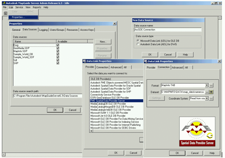
Figure 1: Creating a Data Source Link in MapGuide. Click for Larger Image
After setting the Data Link Properties in MapGuide Server Administrator, the data are then accessible in Autodesk Map Author. You can add the SDP Data Sources by right clicking on Map Layers and selecting the type of layer (point, polyline, polygon, etc.) that you will be adding. (See Figure 2) You will then enter a name for the layer and set the data source for the layer properties. The Feature Table text box lets you specify which feature layer or feature class from a Geodatabase or DataWarehouse to add to the map. Once the feature table option is set, the Key Column, Key Column Type, and Geometry Column will automatically be populated based on the table selected. The Name, URL, Where tab allows you to set the Name column for labeling the layer, a URL column for hyperlinking, and a Where column to create a SQL query to create a subset of the map layer features. The Link to Secondary Table checkbox allows you to create a link to another table and to specify the location of the table.
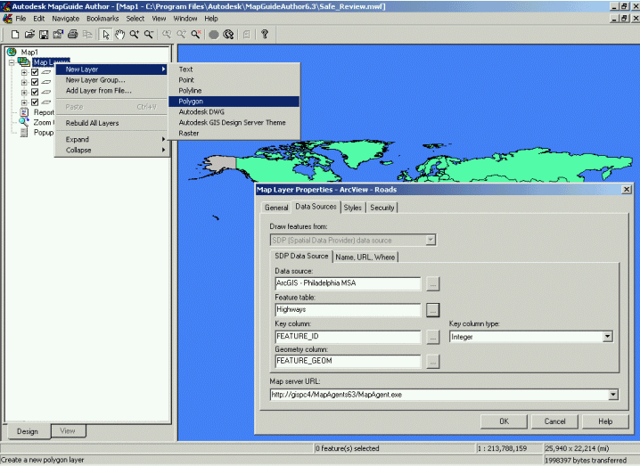
Figure 2: Adding an SDP Data Source to Autodesk Map Author.
The Styles tab allows you to set a style for the layer before adding it to the map. MapGuide can symbolize layers based on a range of numeric values or on individual values. The Theme Defaults button automatically creates the value ranges for a map layer. The ranges can also be set manually, however, you'll have to do each range one at a time. The styles for the individual ranges are set one at a time. Labeling the features and setting the display range for a map layer can be set on the Styles tab.
The Security tab sets an Access Security Key for the map layer. After a layer is added to the map, the Layer Properties can be accessed by right-clicking on the layer and choosing Properties. Once the layers are all set for the map, it can be published to a Map Window File (.mwf) that can be served on the Internet.
Conclusion
The FME SDP Server for MapGuide is intuitively easy to learn. The software
installation CD includes a short movie that demonstrates how to get the
product up and running quickly within MapGuide. Experienced MapGuide users
should be able to create the OLE DB connections and add data through the
FME SDP Server without any difficulty.
I was impressed with the ability of the FME SDP Server to connect to multiple spatial data formats in their native formats and add these data sources to MapGuide. The SDP Server is very stable when used within the AutoDesk MapGuide environment. I was able to perform function such as creating thematic maps and setting definition queries with the SDP layers. Overall, the ability to incorporate spatial data from a variety of spatial data formats into one GIS software application, such as MapGuide, is an extremely valuable function that can be very useful for users that work with many different spatial data formats.