Distributor
Haestad Methods, Inc.
37 Brookside Road
Waterbury, CT 06708
Phone: (203) 755-1666
Fax: (203) 597-1488
http://www.haestad.com
Price - $495
Introduction
GISConnect version 1.0 for AutoCAD is an add-on tool for the AutoCAD
environment that combines the power of ArcGIS’s advanced database and geospatial
capabilities with the extensive use of AutoCAD® drawing
tools. GISConnect adds a new toolbar and a dropdown menu within AutoCAD
that allows users to add ArcGIS spatial data to a drawing in AutoCAD. (See
Figure 1) Once the spatial data are on the drawing, the user can access
AutoCAD’s drawing tools to perform edits to the spatial data. GISConnect
is compatible with AutoCAD 2002 and 2004, and all of ESRI’s ArcGIS products
of version 8 or higher.
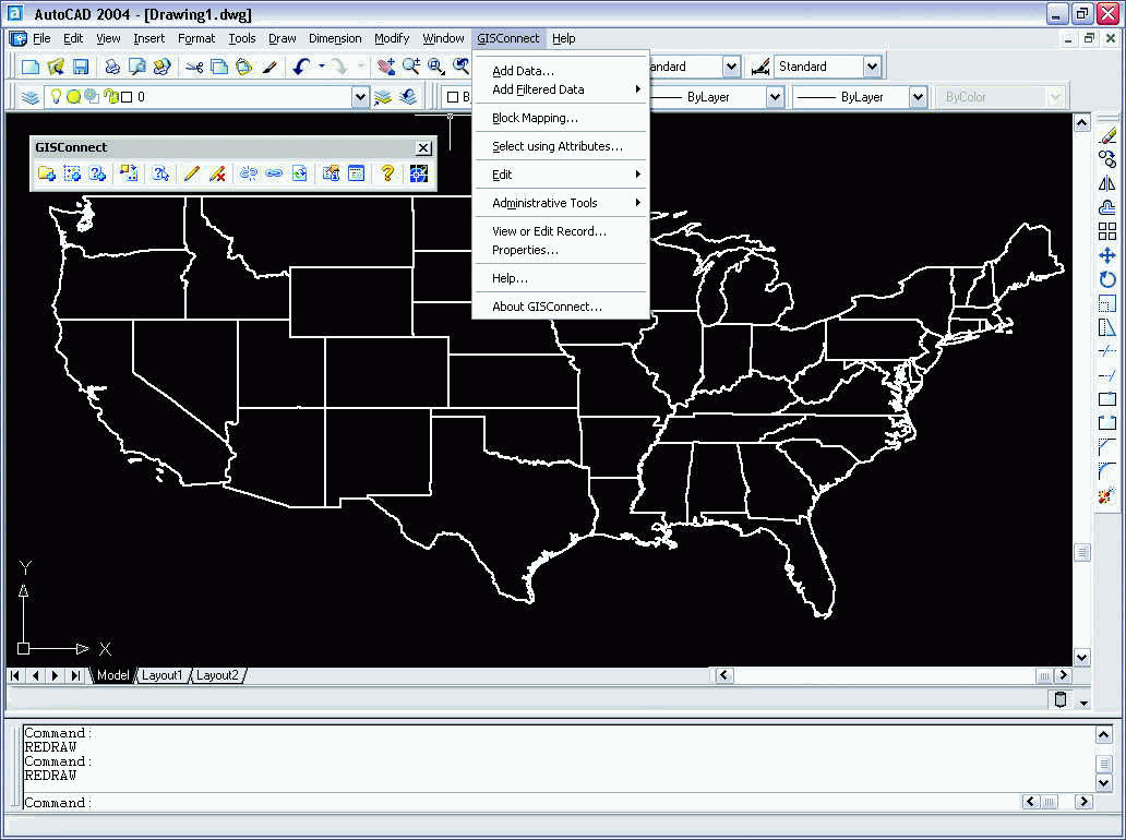
Figure 1: GISConnect toolbar and menu in AutoCAD.
GISConnect Functionality
The GISConnect toolbar and menu provide the following functionality
within AutoCAD:
- Add feature datasets and feature class data to AutoCAD
- Add spatial or attribute filtered feature datasets and feature class data to AutoCAD
- Map point feature classes to AutoCAD blocks
- Select features using the GISConnect Query Builder dialog box
- Start and stop editing ArcGIS data directly in AutoCAD
- Perform disconnected editing from the ArcGIS data source and reconnect the edits and synchronize with the geodatabase
- View or edit an individual attribute record
- Color code GIS data within AutoCAD
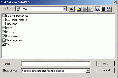
Figure 2: Add Data to AutoCAD dialog box
There are two ways to add filtered spatial data to a drawing in AutoCAD, through a spatial window or through an attribute query. You can add elements that fit within the coordinates defined by a spatial window that can be manually drawn or entered through the command window. The layer added will only contain elements that are located inside of the rectangle drawn as the spatial window. However, if you're looking to add spatial data that meets specific criteria contained in the attribute table, you can subset out records using the Add Data Filter function. The Add Filter Data button opens the GISConnect Query Builder that is similar to the ArcGIS Query builder used to create a definition query for a layer. The Select using Attributes button uses the same GISConnect Query Builder to select elements once they are on the AutoCAD drawing.
Point features are loaded into AutoCAD as point entities. GISConnect has the ability to map point feature classes to AutoCAD blocks in the current drawing, or you can import a block reference from an external drawing. GISConnect can also set block attributes where the attribute label for a block is compared to the attributes label within the GIS datasource. If the labels match, the values will be kept in synch.
Editing elements from a spatial data source in AutoCAD is controlled using the Start Editing and Stop Editing functions. The Disconnect command allows you to disconnect the GIS datasource if it is synchronized to the drawing. The Reconnect command allows you to select the GIS datasource and reconnect it if there is no current link between the datasource and the drawing. The GISConnect Synchronization Dialog assists you in keeping the AutoCAD drawing and the GIS datasources synchronized. You can Update Drawing From Datasource to synchronize the AutoCAD drawing to the GIS datasource. You can also Update Datasource From Drawing to synchronize the GIS datasource with the AutoCAD drawing.
To view the attributes of an element, you press the View or Edit Record button and then select an element on the drawing. The GISConnect Editor dialog box will display with the attributes for the selected element. (See Figure 3) When edit mode is enabled, editable fields are displayed in white, while read-only fields are displayed in yellow. To edit a records, you can double click on the field value you want to edit and enter the new information for the element. The modifications you enter will not take effect until you end the edit session. At this time, a prompt will appear, asking you whether or not your edits should be saved.
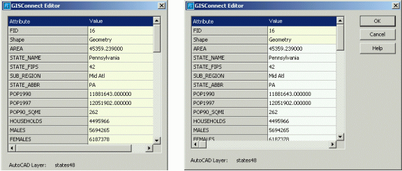
Figure 3: GISConnect Editor dialog box in read-only
mode (left) and editable mode (right).
Color coding spatial datasources within AutoCAD is accessed through the layers properties. To view a list of the spatial data layers, press the Properties button on the GISConnect toolbar. You'll see the layers listed similar to the Table of Contents in ArcGIS. You can right-click on a layer and choose Properties from the popup menu. You can also remove a layer and zoom to a layer from the popup menu. The layer properties dialog box has a Feature tab and a Color Coding tab. (See Figure 4) The Feature tab provides information about the source of the data and allows you to set Block References for a layer. The Color Coding tab allows you to pick a field to color code, set the number of classes, select the color for each class, and change the maximum value in each class. You can press the statistics button to get statistics for the field that you selected for color coding.
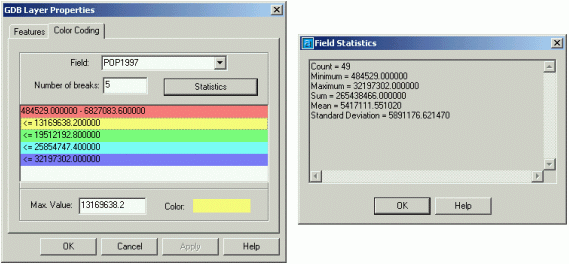
Figure 4: GDB Layer Properties dialog box (left) and
Field Statistics dialog box (right)
Conclusion
GISConnect for AutoCAD provides a bridge of interoperability between
the CAD environment and GIS datasources. The product allows CAD users to
incorporate geographically referenced data into their CAD drawings through
the GISConnect toolbar and menu. I found the toolbar and menu functionality
are straightforward to learn from the tutorial in the Help menu. The product
benefits AutoCAD users that want to incorporate spatial data into their
drawing projects. The product also benefits GIS users that could use the
drawing tools in AutoCAD to perform edits to the features in their spatial
datasources.