
Distributor
DeLorme
Two DeLorme Drive
P.O. Box 298
Yarmouth, ME 04096
Phone: (800) 561-5105
Fax: (800) 575-2244
http://www.delorme.com
Price: $199.95
Introduction
DeLorme XMap 4.0 is a scalable mapping software program that provides
GIS tools at an affordable price. The base package includes the functionality
discussed in this review with some custom datasets. DeLorme provides the
option to purchase additional GIS functionality for XMap such as Map Export
Module 2.0, Image Registration, PhotoFlight and the XMap programming kit.
DeLorme XMap 4.0 is also designed to work with various add-on geographic
databases. The geographic databases come on CD’s and can be copied to the
hard-drive or can be left on the CD. XMap will automatically search your
hard-drive and CD drive for the datasets when the program starts. The databases
that can be purchased separately include:
- 3-D TopoQuads® - USGS 7.5-minute quadrangle maps.
- Sat 10 - 10-meter colorized satellite imagery for an entire state or region.
- Phone Data - 116 million residential and business phone listings.
- USA Street Network - Vector dataset with coverage of the entire United States.
- USA Topographic – Provides elevation profiles of any road or trail and shows the location of land cover including wetlands, forests, glaciers, rock cover, and urban areas.
- Aerial Data Packets (ADPs) – Users can build their own custom dataset containing a composite of USGS DOQs, 7.5-minute Topo Quads (DRGs), Digital Elevation Models (DEMs), and DeLorme’s 10-meter resolution satellite imagery (Sat 10).
The user interface for XMap is shown in Figure 1. The Control Panel on the right side of the interface, under the XMap 4.0 logo, displays information about the map, such as the latitude and longitude position of the cursor, and contains tools to change the map view. XMap has primary and secondary map windows across the top and an overview map in the lower right-hand corner. The purpose of the split map window functionality is to simultaneously display data from two different data sources. The secondary map can be turned off by pressing the split-screen button in the Control Panel (above the scale bar). The secondary window can also has its own zoom level control which affects only the display on the secondary map, otherwise the primary and secondary maps change simultaneously. Delorme XMap is not menu-driven but rather has tabs located across the bottom that provides specific functionality associated with each tab. Figure 2 displays the user interface of the Tabs in XMap. For example, you can set the map data you want to display on the primary and secondary maps using the Map Data tab. There is a Tab Manager that allows you to show or hide certain tabs and to reorder the tabs to suit your own preferences.
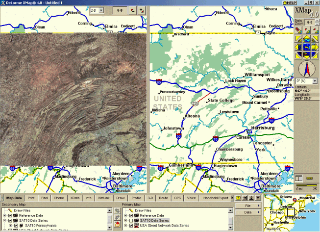
Figure 1: DeLorme XMap 4.0 User Interface with a Primary,
Secondary and Overview map windows and the Control Panel and Tabs. (Click
for larger image)
Tab Functionality
The Map Data Tab shown in Figure 2 allows the user to control the data
that is displayed on the primary and secondary maps. The File button allows
the user to save the current map views into a project file which can be
opened later. The Data button allows the user to add, remove and create
new data to the map view or to specify the location of the XMap base data
sets such as the SAT10 Data Series. Users can turn the display of map layers
by checking or unchecking the box next to the data series name and drill
down to specific layers by clicking on the (+) sign next to the data series
name.

Figure 2 Map Data Tab options (Click for larger image)
The Print Tab provides the ability to customize the printing options of the map layout. There is a Map button that specifies the map that will appear on the layout, the map layout type, print area, and font preferences for text that is placed on the map. Users can press the Print button to print the layout or save the print layout to a bitmap image. The Print Tab also contains functionality to print Route information, create a print profile, and to print a desired XData dataset.
The Find Tab provides three search options: QuickSearch, Advanced and Radar searches. The QuickSearch option lets the user type a placename or address to perform the Search. XMap will then provide a list of the search results in a grid. The user can click on any rows in the grid and the map will automatically center the map on the selected row. The Advanced option allows user to search individual layers for specific geographic information contained within the layers. Users can search for geographic names, street address, street intersections, zip codes, categories, area code/exchange, and latitude/longitude locations. The Radar search option conducts searches within a user-specified radius from a location input from a GPS receiver or the center of the map. The Radar search will list items such as ATM locations, gas stations, and accommodations that fall within the search distance.
The Phone Tab accesses the DeLorme Phone Data Series that can be purchased as a separate database. The Phone tab will search the Phone listing database for a person's name, address, phone number and whether the number is a residential or business phone number.
The XData Tab shows a list of the available datasets that were installed with the software, Users can import data from Text files, Microsoft Access files, Microsoft Excel and FoxPro and dBase files. The data must contain coordinate information (in decimal degrees), a city and state, Zip code, or a complete physical address for XMap to place the records from the file on the map. XMap will then attempt to Geoplace the data on the map based on the type of data. There is a progress bar that shows the placement status of the data and provides a count of the Exact, Near, and Unmatched records that XMap was able to Geoplace. I experimented with a database of 5,800 address records which took XMap approximately 10 minutes to Geoplace. The records were Geoplaced to the street and zip code levels and I was able to review the locations in a table after the records were Geoplaced. The location of the records can be changed afterwards if XMap did not Geoplace a record in the correct location.
The Info Tab lets the user right-click anywhere on the map to get a list of information from each layer on the map. The Info Tab presents a popup menu when the user right-clicks on a map window that prompts the user to Add a Mapnote, Copy Map to Clipboard, and Info. The results of the Info option is displayed on the Info Tab. The Info option provides a list of information from each layer on the map where the user clicked. You can use the Info Tab to get demographic and economic information from the entire 2000 Census.
The NetLink Tab allows the user to download updates for the software and purchase datasets for XMap from DeLorme’s website. The NetLink tab also provides categorical links and searchable keyword links for support of XMap at www.delorme.com.
The Draw Tab provides options to draw graphics on the map such as polygons, lines, and text. The latitude, longitude, distance and bearing are displayed on the left side of the Draw Tab to place the draw objects. The Draw Tab provides symbology options for the draw objects such as style, color, fill and fonts. XMap provides tools to add images to your map and can hyperlink the image to a website.
The Profile Tab generates a cross-sectional Profile Elevation graph of map features, linear objects, multiple linear objects and routes. I'm assuming that you will need to purchase the USA Topographic Data Series to generate profiles of areas because I was unable to create any profiles with the data series that were available for this review. There was no mention in the documentation or the Help menu about the data that is required to generate profiles.
The 3-D Tab in XMap gives users the ability to render a 3-D map of an area for terrain and line of site analysis. The 3-D map can only be viewed in the secondary window. The 3-D Tab provides options for the user to control the Pitch, Rotation and Vertical Exaggeration of the 3-D Map. Users can also change the shading, horizon and display 3-D objects, such as 3-D trees on the map. Figure 3 is an example of the capabilities of the 3-D map in XMap.

Figure 3: 3-D Map Generated in DeLorme XMap 4.0 (Click for larger
image)
The Route Tab generates a route between a Starting point and an Ending point on the Map. The points are entered by placing points on the map, right-clicking on the map and choosing from a pop-up menu, or by typing a location in the text boxes provided on the tab. Users can add stops and vias to set the route through a particular place or along a particular road. You can specify the type of route for XMap to perform the calculation: Roads-Quickest, Roads-Shortest, Trail and Direct. The map displays the route and there is an option to view the driving directions of the route. The Route Tab also has Advanced functionality to set Route preferences and has a Travel Planning option that estimates fuel breaks and approximates the distance traveled based on a certain number of hours traveled in a day.
The GPS Tab provides options to take advantage of Global Positioning Systems through an interface with most GPS receivers, such as DeLorme Earthmate®, GPS TripMate® Trimble and Magellan. The GPS receiver will need to be connected to your computer to use the functionality on the GPS Tab. XMap will display the current position on the map, coordinates and elevation of the receiver. The software tracks the movements of the receiver by showing a trail of dots on the map representing the GPS locations. The locations are saved in a GPS log which can be played back after the trip, switched between users, or saved to a handheld device.
XMap 4.0 includes the Microsoft Speech Recognition Engine which allows you to issue a series of voice commands through a microphone connected to a laptop computer. You can also use other voice recognition software, such as Dragon Naturally Speaking, if you already have that software installed on your computer. You must have a microphone attached to your computer to enable the input. The voice commands shown on the Voice Tab navigate the map, control the map display on the main map, and use GPS tracking features on a laptop as if users are driving their cars.
The Handheld Export Tab in XMap cuts a map which can be sent to a GPS, Palm OS or Pocket PC device. The Data Export Level allows you to specify the zoom level of the map that will be exported, and the Export Preview shows you a preview image of the map. One thing to note with this functionality is that you must have XMap Handheld Pro (sold separately) on your handheld device to view the XMap maps. You can also send and receive route information (points & directions), Draw Points, Waypoints and send a GPS log to a handheld device.
The Map Display Tab customizes the appearance of certain map features and units of measurement to meet individual preferences. Map Display lets you control the features that are displayed on the map, specify the map colors, and the coordinates and measurement of the feature's units. The Use Custom Map Features checkbox lets users choose a specific group of map features that will be displayed on the map.
Conclusion
DeLorme’s XMap 4.0 has a different feel than most commercial GIS software
packages. The user interface is based on the functionality grouped into
Tabs located along the bottom of the window instead of the traditional
Windows based menus and buttons. The software does contain a lot of functionality
that would appeal to GIS users including the ability to geocode, routing
and generating map layouts. The software includes a 200+ page User's Guide
as a pdf file that thoroughly explains all the functionality of the software.
The scalability of the software and the data is another important feature
in that users can purchase only functionality and data specific to their
individual needs.