Distributor
Safe Software, Inc.
Suite 2017-7445 132nd Street
Surrey, British Columbia, Canada V3W 1J8
Telephone: (604) 501-9985
Fax: (604) 501-9965
Website: http://www.safe.com
Pricing
| Product | Single Fixed License** | Single User Annual Maintenance |
| Basic Suite | ||
| FME Desktop Suite | $699 | $200 |
| Professional Suite | ||
| FME Professional Suite | $1,999 | 20% |
| FME ESRI Suite | $2,999 | 20% |
| FME Oracle Suite | $6,299 | 20% |
| FME for GE Smallworld | Contact for Details | |
| Plug-ins for FME Suites | ||
| CCOGIF (writer) | $899 | 20% of SLP |
| GenaMap (reader) | $899 | 20% of SLP |
| GDF (reader) | From $3,999 | 20% of SLP |
| GDF (reader/writer) | From $6,299 | 20% of SLP |
| Intergraph FRAMME SEF (writer) | $3,599 | 20% of SLP |
| NTX Soundings | From $899 | 20% of SLP |
The Feature Manipulation Engine (FME) Professional Suite is an Extract, Transform, and Load tool for spatial data. It consists of three main components: FME Universal Translator, FME Workbench and the FME Universal Viewer. The FME Professional Suite also includes developer tools and coordinate conversion support. There are several purchasing options of FME products depending upon the conversion tools needed. The Professional Suite contains translating options for most spatial data formats except ESRI’s Arc/Info coverages, Oracle Spatial writing, ArcSDE writing and GE Smallworld. Safe Software has developed specific products suites for these data formats that include the functionality of FME Professional.
FME Universal Translator
The Universal Translator is used to move spatial data from a source
format to a different output format. The Universal Translator supports
a large number of spatial data formats which can be viewed at Safe software's
website (http://www.safe.com/products/fme/formats/index.php). To begin
translating files between different spatial data formats, select File-Translate
from the Universal Translator menu or you can drag and drop files from
Windows Explorer onto the FME window. The “Set Translation Parameters”
dialog box will appear where you can specify the Source format and dataset
and the Destination format and dataset. Users can specify a Source format
and navigate to the Source data, or if they dragged and dropped a file
onto the FME window, the Source parameters will be automatically set. Coordinate
systems will be read from the Source data automatically, but can be translated
into another coordinate system for the Destination by choosing from the
Coordinate System Gallery.
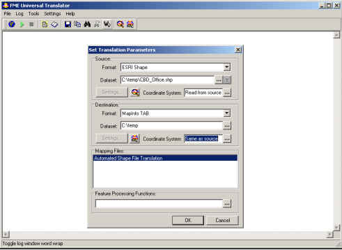
Figure 1: FME Universal Translator
Once you are ready to translate the data, press the OK button on the
“Set Translation Parameters” dialog box. The FME window will show the progress
of the translation in the log view. The Stop button will become available
in case there is a need to stop the translation. Users should be aware
of the size of the files they are transforming as larger files will take
longer to transform. Once the translation is complete you will see a message
in the log view that says if the translation was successful or not. The
information in the Log view can be saved to a log file after the translation
run. You can then view the output in the FME Universal Viewer or in a software
program that can read the destination format.
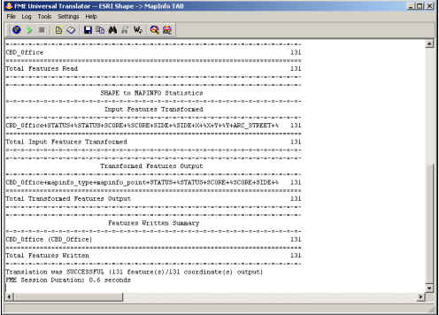
Figure 2: FME Universal Translator Log View
FME Workbench
The FME Workbench offers a graphical interface for accessing the FME
Suite functionality. Users that want to add customizations or detailed
transformations, including those that require multiple input and output
formats, should use the FME Workbench. The FME Workbench can refine the
source data by adding source datasets, removing a dataset, importing another
dataset’s feature type definition, remove existing feature type definition,
and combine data from multiple sources. The FME Workbench can also do the
same with the destination data and can define the data characteristics
of the destination data.
The Workbench window displays the Workspace file where the data is shown
in a tree structure on the left (called the Navigator view) and a graphical
layout on the right. (See Figure 3) The Log view is located along the bottom
of the FME Workbench window. Workbench Transformers allow users to change
their spatial data as it moves from the source to the destination. By combining
transformers, a variety of translation and transformation issues can be
resolved. The FME Workbench includes a Transformer Gallery that is quite
extensive. Users can search the Transformer Gallery by keyword, transformer
name, FME function or FME factory. The Transformer Gallery tab is located
on the tab on the Navigator View next to the Workspace tab.
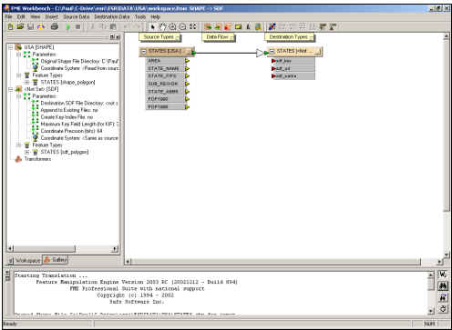
Figure 3: FME Workbench Window
FME Universal Viewer
The FME Universal Viewer allows users to preview any FME-supported
format before or after the translation. The Universal Translator displays
both the geometry and attribute of the spatial data. The Universal Viewer
comes with tools to zoom in and out, identify features, and to pan the
map. Users can also change the styles of the features and symbols of the
spatial data. The Universal Viewer allows users to Mark a location on a
map which can be zoomed to. Dynamic Attributes allows users to add new
attributes to their data and users can specify filters to subset out certain
features from their spatial data without altering the source data.
Conclusion
The FME Professional Suite simplifies the process of converting data
among different spatial data formats. The product can translate data among
a wide variety of data formats from the multiple GIS software vendors.
The Universal Translator is intuitive and very user friendly. I was
able to quickly and easily convert files among multiple GIS software products
using the Universal Translator. For users that require advanced functionality
with regards to transforming their spatial data, the FME Workbench provides
the tools for performing these types of data transformations. The FME Universal
Viewer is ideal for someone that needs to preview data in particular software
vendor's format, but does not have access to use that software vendor’s
program to view the spatial data.