MapInfo Corporation
One Global View
Troy, New York 12180
Tel: 518-285-6000 or 800-FASTMAP
Fax: 518-285-6070
http://www.mapinfo.com
System Requirements
Microsoft Windows 98, 2000, Windows
NT 4.0 and Windows XP
32 Mb of RAM
Minimum of a Pentium processor
16 or 24-bit SVGA monitor recommended
Introduction
MapInfo Professional version 7.0
is the latest release by MapInfo Corporation of their desktop GIS software
product. MapInfo Professional software package includes the installation
CD, 3-D glasses for the 3-D window, and a 759 page User's Guide. The User's
Guide and Reference Guides are also available in pdf format on the installation
CD.
MapInfo organizes all its information within the software in the form of tables that are stored with a .tab extension. For instance, if you open up an Excel spreadsheet in MapInfo, the software will automatically create a .tab file which describes the structure of the Excel data without modifying the Excel table. Tables that include spatial features have a .tab extension, but the graphic features are stored in a file with a .map extension. MapInfo can open tables from Microsoft Access and Excel, dBase, delimited ASCII, Lotus1-2-3, ESRI shapefiles, and Raster and Grid images. Tables remain open in Mapinfo until you close the table from using the File-Close Table menu. Mapinfo stores the configuration of the open tables and windows into a workspace file (.wor).
MapInfo Professional Windows
MapInfo Professional has six major
types of windows that can be open:
- Map windows are used to display geographic objects from a table.
- Legend windows can be created with a Legend wizard to represent a cartographic legend of the layers in a Map window.
- Browser windows show tabular data associated with a layer in the Map window or tables from conventional databases.
- Graph windows present information as graphs to make comparisons of numeric data.
- Layout windows are a page layout feature that allows you to combine your Map, Browser, Legend and Graph windows on a page for presentation quality output.
- Redistricting windows group map objects into districts in order to perform aggregate calculations on the data to provide totals of net values for the districts.
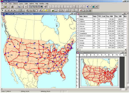
Figure 1: MapInfo User interface with a Map window, Browser window and Layout window open
Users can create new windows or navigate to open windows using the Window menu. Windows can be closed by pressing the x (close) button on the upper right of an open window, but you should note that this deletes the window from your workspace. The user interface is basically the same for the different windows. You will get a specific menu item for the particular window that you have active. For instance, you'll see a Map menu when a Map window is active and a Browse menu when a Browser window is open. The tools and buttons remain the same for each window, but they will be grayed out if they can't function in a particular window.
Tools
There are five toolbars that are
included with the software:
- The Standard toolbar contains tools for commonly performed menu functions from the File, Edit and Window menu.
- The Main toolbar contains tools to select objects, change the views in the Map window, get information about an object, and to measure distances.
- The Drawing toolbar contains tools and commands that are used to create and edit map objects.
- The Tools toolbar has tools for working with MapBasic and buttons that display when the tools are loaded.
- The DBMS toolbar contains tools that are used to access tables residing on remote databases.
Options
The options menu allows the user
to set default display styles for regions, lines, symbols and text. Users
can control which toolbars are displayed and whether to show the Legend
window, MapBasic window and Statistics window. The Preferences option lets
users to specify their preferences for the System settings, Map window,
Legend window, startup, Address matching, directories, output settings,
printer and style preferences.
Map Layers
MapInfo Professional stores tables
that contain geographic information into layers in the Map window using
a layer control dialog box. (See Figure 2) The layer control dialog box
can be accessed through the Map menu or by pressing the layer control button.
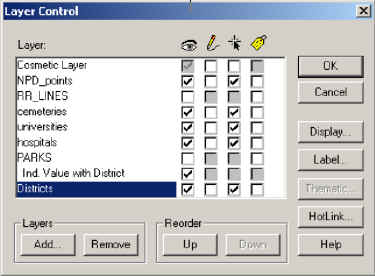
Figure 2: MapInfo Layer Control Box
The cosmetic layer is a blank transparent layer that lies on top of the other map layers. The cosmetic layer stores map titles and other graphic object and can be turned on or off similar to the other layers. The cosmetic layer is always the top map layer and it cannot be removed or reordered. Cosmetic objects can be saved or cleared using options on the Map menu.
The first column of checkboxes in the Layer Control dialog box, under the eye icon, controls whether a layers can be displayed on the map by checking or unchecking the box next to the layer name. The second column of checkboxes under the pencil icon controls whether a layer is editable, only one box can be checked at a time making only one layer editable at a time. The third column of checkboxes under the arrow icon controls whether a layer is selectable for operations such as to get information about a map feature with the Info tool. The last column of checkboxes under the tag icon controls whether the labels for a layer are displayed on the map.
The Layer control box has a series of buttons to Add or Remove layers from the Map Window and to reorder the layers. The Display button on the right control provides options to change the style of the features in a layer. The Label button allows the user to set the font for the labels for a layer. The thematic button changes how the thematic display of a layer. Thematic layers can be created using the Create Thematic Map option in the Map menu. Thematic layers are displayed above the layer they represent with the following notation with/by (ex. See Ind. value with District in Figure 2). The Hotlink button allows users to setup hotlinks on objects and/or labels for a layer.
The Map menu also includes functionality
to create 3D and Prism maps. The 3D maps and Prism maps will open in a
stand-alone window that allows you to rotate, pan and zoom on the viewpoint.
Users can set the projection, coordinate units, distance units and area
units using Options in the Map menu.
Editing and Drawing Features
MapInfo provides a complete set
of drawing tools and editing commands to edit objects on the map. If you
wish to edit a specific layer, make sure that you check the editable box
next to that layer in the Layer Control dialog box. The drawing toolbar
has tools to draw arcs, ellipses, lines, polygons, polylines, rectangles,
rounded rectangles, symbols and text. The drawing toolbar also has buttons
for the user to set the style for the drawn objects and a Reshape and Add
Node buttons for working with nodes on features. The Object menu has additional
functionality to edit objects such as Combine, Disaggregate, Split, Erase,
Smooth, Unsmooth, etc.
Selecting Records from Tables
MapInfo provides two methods to
select records from tables. You can select records from the screen or you
can select records using queries. To select records on the screen, Mapinfo
provides the Select tool, Radius Select tool, Boundary Select tool, Polygon
Select tool, Marque Select tool and the Invert Selection tool. To select
records using queries, a user can use the Select or SQL select commands
from the Query menu. The Select command allows you to select records based
on a condition for a single table. The SQL Select provides the functionality
of SQL that allows you to create queries to aggregate data, group data,
order data and join multiple tables.
Records that are selected are stored in a temporary table. You can access the temporary table by selecting New Browser Window from the Window menu. Once you close the table with the Close Table command, the temporary table is removed from the workspace and you will have to recreate the selection to view the selected records.
Table Manipulation
The Table menu provides the functionality
to manage tables in MapInfo. Users can update columns with new values that
the user specifies or from separate table. Tables that contain address
information can be geocoded against a Search table or the user can automatically
create a point layer on a map if the table has x,y coordinates in the table.
The Table Maintenance option provides functions to modify the table structure,
delete tables, rename table and pack tables. Modifying the table structure
allows a user to add or delete fields from a table, and to view the data
types associated with each field and the ability to change the data type
of a field. The Table menu also has options to Import and Export data to
and from different formats.
New Functionality in version 7.0
- Enhanced Operating System Support: MapInfo supports Windows 98 and NT 4.0 and has been certified for Windows 2000. MapInfo has also received the “Designed for Windows XP” logo.
- New and Enhanced Database Support: MapInfo supports the latest versions of Oracle Spatial, 9i and 9i Locator, SpatialWare® 4.6 on all its supported platforms, Microsoft Access 2000 and SQL Server, versions 7.0 and 2000.
- Ease of Use Improvements: The Open Dialog box has been redesigned for efficient access and management of files. The Find in Front Window Only options allows users to perform a Query Find in only the front window.
- File Type Support: MapInfo provides the ability to open shapefiles directly from the File-Open dialog box. Raster handlers are installed that support government agency formats, ASRP, ADRG, CADRG, CIB, and NITF, as well as MrSID and ECW raster handlers. MapInfo also provides the ability to import OSGB format GML files.
- New and Enhanced Map Creation and Editing Objects: MapInfo can now rotate map features in addition to text and labels. The arrow keys on the keyboard will move selected objects in an editable layer. The backspace key can be used as a delete to undo the last node when using tools for editing polygons and polylines.
- New and Enhanced Object Processing: MapInfo can create Voronoi Polygons for trade area or coverage area analysis. The Split by Polyline feature creates custom objects by splitting both closed and linear objects with a road or user-defined line.
- New and Enhanced Map and Layout Display Options: There is a new North Arrow tool that places a North Arrow with the style that the user chooses in the map or layout windows.
- New and Enhanced Publishing Options: MapInfo provides a new version of Crystal Reports with the ability to publish to HTML, export to HTML or PDF and OLE2 embedding capabilities. MapInfo provides the ability for the user to set default preferences such as default projections, styles, DBMS connections and Auto Scroll. They have added or improved the following tools: Coordinate Extractor Tool, TOC Utility and the Universal Translator. There is also several new projections added, sample data improvements and additional MapBasic support.
I tried to structure this review to give a complete overview of the software for someone that has never used the product and to provide information regarding the latest updates for experienced MapInfo users. MapInfo Professional was the first GIS software program that I learned back in graduate school several years ago. The feel of the software and ease of use has been the same throughout the progression of versions that have been released since that time. MapInfo Professional continues to upgrade its software product to reflect changes in the operating system and database system environments, while adding new tools and functionality to improve the product.