Live updates on ArcGIS solutions and more from the Esri User Conference being held July 8 - 12, 2019 at the San Diego Convention Center in San Diego, California.
Last updated: 7/11/2019 12:11
Learn more about our visit to the Esri event using the new Story Maps tool from Esri.
SpatialStream
Digital Map Products
"Our nationwide parcel database, SmartParcels®, and additional location datasets are compatible with the Esri suite and can be integrated into Esri apps via either delivered on-premises data or integrated APIs. SpatialStream® for ArcGIS supports streaming data delivery into ArcGIS Pro, configured ArcGIS applications, and custom-built applications."
— David Mertz, Associate Product Manager, Digital Map Products
https://www.digmap.com/platform/spatialstream/
High-Accuracy GPS for Esri Survey123 for ArcGIS (mobile app)
Eos Positioning Systems
"Water utilities need that basemap with GPS locations, to be able to use other software for other workflows, like facilities management. Having an accurate asset inventory also means that if a state or federal organization comes in and says, ‘You have to replace all the pipes that date back to a specific time,’ these water districts can then respond positively, having now the required resources to do this."
— Al Schaeffer, President, Northern Forests LLC
https://eos-gnss.com/arrow-100-for-infrastructure-mapping/

Real-Time Geoid Height in Esri Collector
Eos Positioning Systems
"Field technicians in pipeline, construction, engineering, architecture, water, and any other industry are finally able to enjoy survey-grade vertical accuracy on their iOS and Android devices, with the Esri data-collection app of their choice (e.g., Collector) and their Eos Arrow GNSS receivers."
— Jean-Yves Lauture, CTO, Eos Positioning Systems
https://eos-gnss.com/collect-geoid-height/
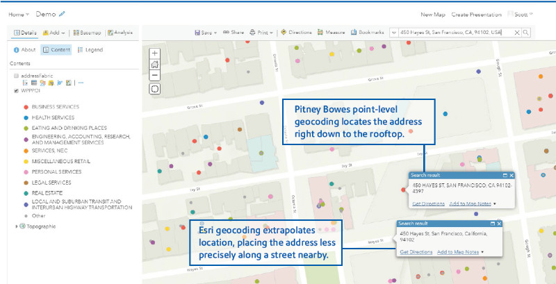
PBLocator
Pitney Bowes
The new PBLocator makes it simple to access world-class Pitney Bowes geocoding directly within ArcGIS Online and ArcGIS Pro Desktop environments.
http://pitneybowes.com/us/location-intelligence/geocoding-data-enrichment
ZIP+4 Code Boundaries
AND Products BV
With the ZIP+4 Code Boundary data you can perform hyper-local, anonymized actuarial analysis as never before which adds an amazing granularity.
https://www.and.com/and-zip4-code-boundaries/

ParcelAtlas
Boundary Solutions, Inc.
BOUNDARY SOLUTIONS, INC. Proudly offers ParcelAtlas, Industry’s Most Powerful National Parcel Layer (NPL) Solution. Why the most powerful NPL? Drawing on the experience of early ParcelAtlas users, it is proving to be the most cost effective one available by far for just one reason - ParcelAtlas, and only ParcelAtlas, is INSIDE ArcGIS® Online, not OUTSIDE. Try ParcelAtlas FREE and experience the quick refresh times of live content and the ease and speed of large spatial queries even across multiple counties.
https://www.boundarysolutions.com/BSI/ParcelAtlas/page1.html

Maptitude for Redistricting Extension for ArcGIS
Caliper Corporation Mapping Software
Maptitude for Redistricting is available as an ArcGIS extension. As a result, you have access to the redistricting functionality and ease-of-use of Maptitude for Redistricting while leveraging your in-house expertise in ArcGIS software and all of your existing Oracle, SQL Server, DB2, and other data through the ArcGIS DBMS support.
https://www.caliper.com/redistricting/extension.htm

Nearmap High-Resolution 3-D Aerial Imagery
Nearmap
“The blend of Esri’s mapping technology and Nearmap’s current and historical imagery have allowed our team to identify features that are essential in stormwater billing. Because of the resolution from Nearmap and the functions in Esri, we’re able to efficiently complete the change analysis and deliver timely, accurate billing to our ratepayers. If we had to rely on other sources of imagery, which are not available in a timely manner, we simply could not get the job done.”
— Jeff Duke, manager of GIS Services at Northeast Ohio Regional Sewer District
https://go.nearmap.com/aerial-imagery-products

Trimble TDC600
Trimble Geospatial
"The Trimble TDC600 is a next-generation smartphone that integrates with Trimble Catalyst and Esri Collector for ArcGIS for a powerful solution for GIS data collection. It is a new addition to our portfolio of handheld, tablet and integrated devices, which we think offers something for everyone needing scalable and affordable high accuracy GNSS positioning."
— Gareth Gibson, Mapping and GIS solutions portfolio manager for Trimble Geospatial
https://geospatial.trimble.com/tdc600

PhotoMesh
Skyline Software Systems
Skyline Software Systems 3D Reconstruction Tool, Photomesh, is capable of producing I3S Textured Mesh outputs for an easy and simple integration into all compatible ESRI tools.
http://skylinesoft.com/SkylineGlobe/corporate/Products/photomesh.aspx

Automated Utility Design (AUD) Version 8.0
Spatial Business Systems, Inc.
"ArcGIS and AutoCAD now work together seamlessly to support utility distribution design. This solution leverages the power of Esri's Utility Network working with collaboratively with SBS Automated Utility Design."
— Dennis Beck, President, SBS.
http://www.automatedutilitydesign.com

Spike
ikeGPS
This quote is from Patrick Baber, GISP – GIS Manager, City of Roswell, Georgia. In close collaboration with Geographic Technologies Group, the City of Roswell is developing a 3D Historic District using ArcGIS Pro, with additional usage of Collector and Spike by ikeGPS.
“Roswell’s Historic District is the focal point of the City. With high demand for location, and strong feelings both for and against change, development within the Historic District is frequently a topic of discussion for Roswell’s government. A dynamic 3D environment will be an invaluable tool to visualize existing buildings, tree covers and other assets within the District, as well as conceptualize any proposed future development. The Spike device was a simple and inexpensive method to augment older, less accurate LiDAR data with the information necessary to create the 3D shapes for the project . We are excited to deploy the 3D environment, and the Spike devices and collection methods are essential to the success of the project.”
https://ikegps.com/esri-survey123/

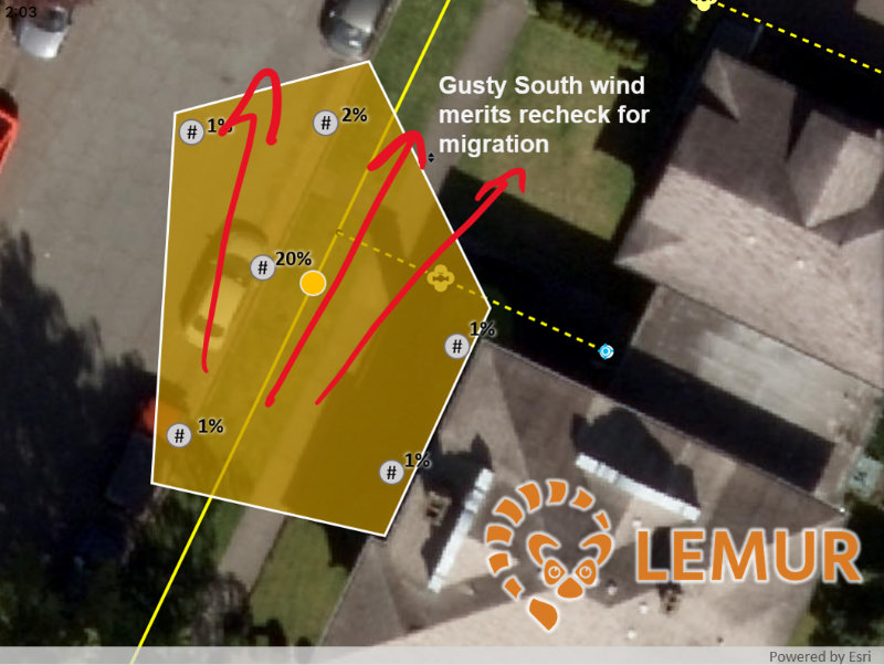
Lemur
Critigen
Lemur makes GIS an integral part of field workflows for asset management. Lemur takes technicians seamlessly from work orders to spatial information and and back to the work order without redundant data entry or confusing navigation. The process is so smooth and configurable, users love it!
The Argis Lens
Argis Solutions, Inc.
"I believe in providing my crews with the best possible tools to get the job done in an quick and efficient manner. The Argis Lens helps my teams visualize GIS features instantly, and provides a unique window into our data. Ultimately this leads to less time on the job site, and more jobs getting done. Our field guys love using Argis Lens!"
— Myles R., City of Englewood, Colorado
https://www.argis.com/lens-gallery

Import and Export DWG files into and from ArcGIS
GIS-WIZ
Our Import and Export extensions are used on a daily basis in water companies as a "bridge" that shortens the data integration between different stakeholders that use AutoCAD and ArcGIS for Desktop.
https://www.gis-wiz.com/copy-of-smartercad
SiteVisit360
SOLV3D Inc.
"With SiteVisit360, we were able to show the client how they could virtually locate, inspect and tag areas of interest. The fact that large amounts of geospatial data can be accessed through any connected device by non-technical stakeholders was a huge selling point. The integration of SiteVisit360 with our existing ArcGIS Online and AutoDesk solutions make it an extremely powerful tool."
https://solv3d.com/solutions/sitevisit360/
Avenza Maps
Avenza Systems Inc.
"I periodically look at other mapping apps that might benefit our work and haven’t really found one better than what you guys have. I appreciate that I can talk to the team from time to time about our needs and where the developers plan to take the app. I sincerely hope Avenza will continue leadership in this app space."
— Lance Case, GIS and IT Specialist from Huber Forest Resources.

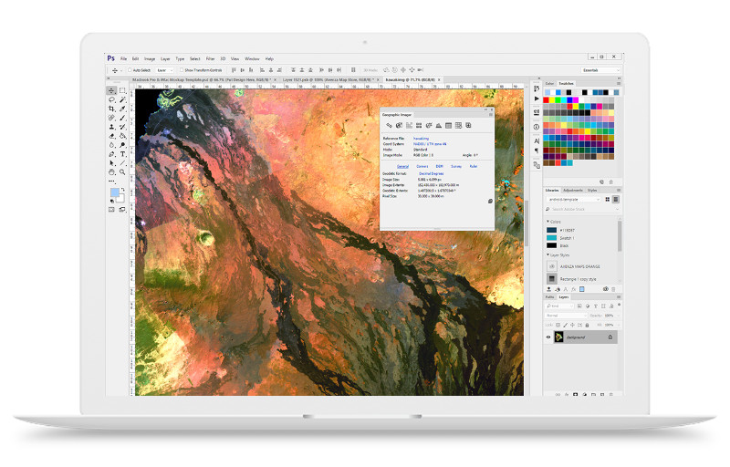
Geographic Imager
Avenza Systems Inc.
“MAPublisher and Geographic Imager bridge the gulf between graphical and GIS worlds.”
— Tom Patterson, Cartographer from an article on our blog
https://www.avenza.com/geographic-imager/
MAPublisher
Avenza Systems Inc.
"I spent all weekend moving my map from ArcGIS to Illustrator with great success. I have data in sde and file geodatabases and have been able to bring in data without any problems. The end product for this project will be so much better now that I can get it to Illustrator for layout an printing. The other side of this map is being laid out by a graphic designer and the continuity of colors and design will be so much better since we can now work in the same program."
https://www.avenza.com/mapublisher/
Streetlogix
StreetScan
"I continue to be impressed with the level of sophistication of the information and decisions provided through such an easy-to-use interface."
—Mike Collins, Public Works Commissioner of City of Beverly
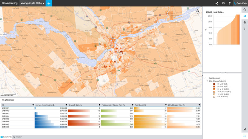
CartoVista
CartoVista
Sometimes a map needs to be supported with additional dynamic data. With CartoVista's data panels, filter options and thematic mapping capabilities, a shapefile can be turned into a web ready interactive map that helps decision makers make more informed choices.
Laser Offsets for Collector on iOS
Eos Positioning Systems
Seattle Zoo Builds Basemap Around Lions, Tigers, and Bears
https://eos-gnss.com/product/solutions/laser-mapping/
EOS GPS & LTI Laser Offsets in Collector to Capture Utility Locates
Downtown Design Services, Inc.
Combining these available solutions saves us time in the field, which in turn makes our projects more profitable

LaserGIS Mapping
Laser Technology, Inc
By combining high-accuracy GNSS receivers and the laser capabilities of LTI, we can empower field crews to capture highly accurate XYZ coordinates from a safe distance. It eliminates the need for physically occupying every point. It also provides more accurate location data, with more affordable mobile asset-management workflows within Collector for ArcGIS.