Charlotte Firm Takes on Major Airport Renovation
If engineering firms could earn frequent-contractor points, the CES Group Engineers would likely be triple-platinum members. The company’s professional and surveying crews have been at the Charlotte Douglas International Airport nearly every day as part of the $3.1 billion renovation program to expand CLT’s roadways, airfield and terminal. Being an integral part of the project is a testament to how far the company has come from surveying residential lots after opening its doors for surveying services eight years ago.
“Our surveyors and engineers are out in the field nearly every day and they get noticed for the quality work they do,” said Judy Heleine, owner of CES, based in Denver, N.C., about 25 miles northeast of Charlotte. “That experience, knowledge, responsiveness and enabling technology allows us to deliver the required precision on one project and helps seal the deal on the next. It’s a winning formula that has earned us a place on some of the highest-profile projects in the region.”
As early users of advanced survey and geomatics technologies, CES has been able to expand its breadth of services and contract opportunities.
“We invest heavily in varied technology that allows our licensed land surveyors and field crews to tackle any surveying job out there,” said Kent Hudson, PLS and CES’ geomatics division manager. “Each new piece of equipment builds our expertise, which helps us deliver specified results on time and on budget, heightening our profile and enabling us to secure immense projects like CLT.”
Taking flight
CLT jumped from the 18th busiest airport to the 11th in a decade, and is now the 10th busiest passenger airport in the United States, ranking higher than Orlando, Miami and Houston, welcoming 46.4 million domestic travelers and 3.2 million international passengers per year.
With all indicators showing increased passenger demands, airport executives developed “Destination CLT,” a master blueprint that defines the construction and renovations it needs to ensure it has the capacity to handle growth through 2035. Given CES’ proven performance on previous airport design and construction surveying projects, and its knowledge of the facility, CLT consultants and contractors chose the company as the primary survey provider for more than 24 projects. Since construction work began in 2015, CES survey crews have been instrumental in most anchor projects, including the $200 million expansion of Concourse A.
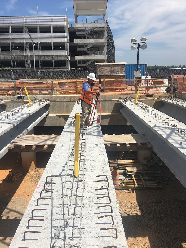
Assisted by their Trimble S7 Robotic Total Stations, Trimble DiNi Digital Levels and TSC3 and TSC7 data collectors, CES field teams have been providing all aspects of construction staking. “We’ve had to ensure that all of our horizontal and vertical points are accurate to within 0.01 of a foot,” said Hudson. “That’s not easy to consistently maintain when you have such a chaotic, machine-heavy and sometimes cramped work site. But despite the challenging and unexpected conditions, we’ve been able to stay on spec every day.”
And since the summer of 2018, they have been able to extend the breadth and detail of their data through the addition of Trimble’s SX10, a scanning total station that combines surveying, imaging and scanning. That functionality has proved particularly useful for two other massive airport projects: the Elevated Roadway and the South-Crossfield Taxiway.
“The SX10 has become instrumental on CLT projects,” Hudson said. “It’s not only giving us the flexibility, speed, mobility, precision and safety we need; it’s reinventing some of our historically traditional survey approaches and creating new business opportunities.”
Beyond cruising
CLT’s EVR project is widening the existing four-lane terminal approach road to 16 lanes to create badly needed space. Five new upper lanes of the EVR and four temporary passenger walkways were opened in April 2019, marking the completion of Phase 2 of the $50 million initiative.
Initial construction began in November 2015 and CES crews were on site from day one. Every day for three years, field teams were using their survey equipment for installing control points and staking out curbs, piers, girders, columns, as-builts and bridge bents. They also used their technology to locate existing storm and sewer infrastructure and stake out new construction points for rerouting and replacing those systems.
“We had extremely tight tolerances to ensure all the pre-fabricated steel beams fit correctly and were at the correct height and horizontal plane dictated by the design,” Hudson said. “All of our measurements had to be exact.”
CES was also asked to perform as-built surveys of the support columns for the elevated roadways and bridge ramps. As they had just acquired an SX10, the timing proved opportune. CES had been doing column as-builts with their traditional equipment and it was painstaking. Crews needed to measure the circumference, shoot multiple points around the column, bring that data back to the office and then calculate the “best fit circle” to indicate the column center. Using the scanning function of the SX10 allowed them to capture the entire column at once.
“In addition to the time-consuming process, traditional techniques require a prism, which can introduce some error because of its thickness,” Hudson said. “So, you have to perform many calculations and checks to ensure you’re precise. With scanning, you get the actual surface so it’s easy to pinpoint the column center.”
With the SX10 available, a field team opted to scan seven remaining bridge columns –– the instrument’s debut project at CLT.
CES crew chief, with properly secured safety harness, completing as-built survey of elevated roadway girders, using Trimble S7 Robotic Total Station and TSC3 Data Collector.
They had to verify site control every day. The two-person crew set the scanning total station on a control point and scanned the first column 100 feet away. They performed that routine three more times, and in less than three hours, they captured 3D, 360-degree views of each of the seven columns at an accuracy of 0.01 feet. They saved the data on their TSC7 controller using Trimble Access field software, which combines optical, scanning, and GNSS data plus images in the same job.
“Scanning eliminated the need for setting traditional targets and provided a safer working environment for our crew,” Hudson said. “And we captured substantially more data –– millions of data points –– in half the time it takes with the conventional methods.” Back in the office, Hudson input the SX10 point cloud into Trimble Business Center software for processing and quality control. He then exported the 3D data into AutoCAD to produce a final drawing showing the column centerline locations. Per the client’s request, they delivered the drawing as a PDF.
A smooth ride
In January 2019, one of the primary design consultants on CLT needed survey support for CLT’s ambitious South-Crossfield Taxiway project: a new 4,000-foot-long taxiway and bridge that will connect the central and east side of the airfield. CES worked with the consultant company on previous projects for the City of Charlotte, in which they produced cost-effective, high-quality deliverables on time. Based on that success, the company selected CES for the SCT project.
CES’ field crews were tasked to create a topographic survey of the entire site, which consists of dense, wooded areas; low vegetation areas; flat, open taxiways; and elevated retaining walls and ramps. They needed to locate and map utilities, taxiways, runways and ramps. Such a varied landscape required multiple technologies and approaches. However, because this site is located within CLT’s airfield, CES was required to perform their work overnight to avoid disrupting airport operations and to ensure their safety and the safety of airport and airline personnel. They set control using Trimble R8s GNSS receivers, occupying each control point multiple times and then calculating the averaged coordinates for each point. They then ran a closed traverse loop using the S7 for horizontal control and the DiNi level for vertical control to within 0.01 feet. With control established, three different survey crews used S7 total stations and TSC7 data collectors to collect field data including ground shots, utilities and critical tie-in points.
There was one challenging area: a 40-acre, concrete cargo area, kind of a “flat” apron comprised of 107, 20-by-20-foot concrete slabs laid in a grid pattern. CES was required to locate and pinpoint every concrete joint, or seam, within this area, along with any grade change over the cargo space and taxiways.
“To acquire that kind of survey over 40 acres would have required us to take 5,000-7,000 shots using our total stations,” Hudson said. “We’d have to set a rod every 20 feet, take a shot, and move to the next point 20 feet away. Although our technology would deliver on the precision, I calculated that it would take eight nights of work to complete it. Having seen the speed, range and accuracy of the SX10, I thought it might be a better alternative.”
He thought right.
Arriving on site at 11 p.m., he and his colleague used the previously established primary control network and set additional “spur” control points as needed. Setting the scanning total station on a chosen control point, Hudson captured the scene, collecting not only the concrete joints and surface-elevation variations, but also the tops and bottoms of retaining walls, storm grates and building corners at distances up to 300 feet from the instrument. In 10 scanning set ups, the crew captured the entire 40 acres in a single seven-hour shift.
“I didn’t think I’d use the scanning functionality on a huge, flat surface so I wasn’t sure how it would perform, particularly in low light,” Hudson said. “I went to the site expecting it would be a three-night job, and I was shocked that we got it all in one night. Our dealer, Duncan Parnell, had assured me that darkness wouldn’t be a problem, and they were right. I not only acquired millions of 3D points that clearly show all the concrete seams and subtle grade variations, I captured substantially more data in nearly 13 percent of the time.”
Additional efficiency came from the “big picture” screen of the TSC7 and the integrated survey workflow provided through Trimble Access, which enabled crews to seamlessly manage the data from many tasks and sync it between field and office in real time.
“The large controller screen makes it easy to see in any environment, like bright sun, overcast, in the middle of the night and even wearing polarized sunglasses,” Hudson said. “That allows us to quickly set up new jobs and move between jobs. And with Trimble Access we can transfer data between the office and field in real time and check emails so it’s like having your office with you.”

Actual scanning image of a portion of the 40-acre concrete cargo area, with dots representing millions of points collected by the SX10
In the office, Hudson processed the point cloud using TBC software and its automated extraction tools to remove any extraneous features, such as parked airplanes. After cleaning the data, he created a 3D topographic model of the 40-acre concrete apron and exported it into AutoCAD to produce a final 3D surface. Two days after capturing the data, CES delivered the topographic survey to their client. Since finishing that survey, CES teams have been back on the SCT site with their S7 total stations to collect the locations of sewer and storm systems across the 300 acres. Work on SCT will continue through 2022.
Between the airport and other projects, CES won’t be sitting idle; it just opened its third office in Columbia, S.C. With a docket that looks as full as CLT’s departure board, those ethereal frequent-contractor points probably wouldn’t get used anyway.