The Challenge
Precision agriculture is a farming management concept based on observing, measuring and responding precisely to plant requirements. Using modern eco-friendly technology, (e.g., remote sensing, sensors, GPS and data analytics), precision agriculture aims to increase the efficiency of the use of resources and reduce the uncertainty of decisions required to control variation on farms, ultimately ensuring profitability, sustainability and protection of the environment. End-to-end precision agriculture is a fully integrated system used to improve profitability and productivity while minimizing the environmental footprint. It enables farmers to take action to improve their land resource productivity in near real time.
New Zealand is recognized as one of the largest exporters of agriculture products such as dairy, meat and wool, and therefore, the country’s agriculture economy relies heavily upon grazed pastures. Grasslands are among the world’s most extensive terrestrial ecosystems and are a major feed source for livestock in New Zealand. Consequently, estimating pasture quantity and quality can help farmers determine and provide the most advantageous diet for livestock to optimize animal performance and stocking rates. But adopting precision agriculture in grasslands is challenging due to their complex environments: Grazed pastures feature perennials and have different growth stages, multiple species, animal interference from variable grazing patterns, excreta and urine patches.
Traditional methods used to estimate pasture quality involve destructive and labor-intensive procedures whereby pasture samples need to be cut and sent to a lab for chemical analysis. This sampling method is slow and very expensive (an estimated $200 per sample, plus milling and prep costs); as a result, only a limited number of samples can be measured. In many cases, by the time the pasture quality information reaches the farmer, the pasture has already been grazed by livestock.
Dr. Pullanagari Reddy, senior research officer at New Zealand’s Massey University, is leading a research team focused on developing an end-to-end precision agriculture program that includes a complete workflow of measuring, modeling and precision management to characterize and quantify biophysical and biochemical features of pastures in New Zealand. The research team uses advanced remote sensing technology to measure the spatial variability in pastures and soil.
The Solution
New Zealand has a unique geographical position: It is isolated, long and narrow, and covered with mountain ranges; cloud cover is extensive and clear sky is available only for a limited time. Remote sensing allows the mapping of the Earth’s surface from satellite or airborne systems; however, several factors affect its ability to correctly interpret plant properties, such as solar elevation, sun angle, sensor view, atmospheric parameters and cloud movement. Accurate measurements are essential to quantify vegetation properties and the complex environments of grassland areas, hence, the need for a proximal sensing system to collect detailed information near the surface.
Malvern Panalytical’s ASD FieldSpec® is a portable full-range (350 nm – 2500 nm) spectroradiometer that provides uniform visible-near infrared data collection. VNIR is non-destructive, requires little or no sample preparation, and can be used to analyze multiple constituents in a single scan.
“ASD is a perfect instrument for ground truthing the airborne and satellite-based optical sensors.”
— Dr. Pullanagari Reddy, senior research officer at New Zealand’s Massey University
Dr. Reddy and his team employed the ASD FieldSpec 4 Hi-Res spectroradiometer to ground truth airborne hyperspectral overflight data; they also used the instrument to develop a model using chemometrics (i.e., multivariate statistics and machine-learning algorithms), thus enabling their ability to quantitatively map grassland properties.
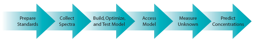
Near-infrared spectroscopy chemometrics is a widely used method in the industrial setting that takes compositional, or other, information of a representative set of samples to correlate with measured reflectance spectra to develop a statistical calibration model. This calibration trains the instrument to analyze additional unknown, but related samples, essentially leveraging the detailed and more costly analysis of a few hundred samples to analyze a much larger set of related samples. When this technique is applied to remote sensing, it can be re-cast a bit: In a hyperspectral remote sensing application, compositional or other information of a representative set of samples is correlated with reflectance spectra measured in the field to develop statistical calibration models; however, it can now be applied to an entire hyperspectral scene, leveraging the analysis of field collected and measured samples to produce an entire image of material property or concentration.
NIRS Chemometrics Calibration Procedure - steps for field and lab applications (Image/ASD)
Since 2010, Dr. Reddy’s team has been collecting thousands of spectral measurements, from a wide range of farm conditions and during different times of the year, to create a large database. The collected spectra have been carefully preprocessed to remove noise, then applied to different algorithms to select the best bands for modeling pasture properties. Dr. Reddy’s team developed an individual statistical calibration model for each pasture quality parameter, which included crude protein, fiber, metabolizable energy, phosphorous, potassium, sulphur and zinc. The performance of the models was evaluated using internal and external validations. The team also quantified botanical composition using spectral measurements: clover percentage, rye grass percentage, species diversity and indicator plants. With this information, Dr. Reddy’s team was ready to move from a point scale to spatial and commercial scale.
Based on the success of this proximal sensing study, the Ministry for Primary Industries, New Zealand’s public service department, entered into a seven-year joint research Primary Growth Partnership program with Ravensdown Limited called, “Pioneering to Precision – Application of Fertilizer in Hill Country.” AgResearch, a Crown Research Institute, was contracted to collect much of the supporting field data, while Massey University led the remote sensing development. The main aim of the project was to develop a methodology to sense the nutrient status of grassland farms using remote sensing technology to link to soil fertility, and deliver fertilizer precisely using GPS-guided topdressing aircraft. The research goal is to develop a precision agriculture program including a complete workflow, such as measuring pasture, modeling, estimating soil fertility and precision management.
The Results
Implementing remote sensing techniques can effectively improve farm productivity and profitability. However, a number of challenges exist: capturing high-quality remotely sensed data is expensive; developing robust predictive models and appropriate image-processing algorithms that produce relevant, processed data layers and grassland environment models is difficult; last but not least, linking model outputs to the formulation of precision nutrient management practices and being able to produce a monitoring and feedback system returning quality field data from project areas to improve the modeling process is challenging.
Dr. Reddy’s team’s end-to-end precision agriculture research studies can help ensure farm sustainability and profitability while minimizing the negative impact on the environment. The majority of the team’s research work within a larger research effort focused on discrete components of end-to-end precision agriculture, such as:
- characterizing pasture using different sensors
- modeling spatial variability of soil
- data analytics
- variable rate fertilizer application modeling
The ASD FieldSpec spectroradiometer is an imperative tool to measure pasture quality of grassland areas in the end-to-end precision agriculture process, providing information in near real time. Providing information in near real time is essential to make on-farm decisions quickly and precisely. The ASD instrument, as compared to other sensors, is easy to use and significantly reduces the time gap compared to traditional methods, making it the most cost-effective choice to estimate pasture quality parameters non-destructively in near real time. Use of the ASD spectroradiometer and chemometric techniques proved to be a faster and less expensive methodology for characterizing pastures.
Acknowledgements
Dr. Reddy would like to gratefully acknowledge the team members at Massey University, Professor Ian Yule, Pip McVeagh, Eduardo Sandoval, Sue Chok, Gabor Kereszturi and Matt Irwin, and at AgResearch, Robin Dynes and Grant Rennie.