
Using Gnss-reflectometry Data to Map Arctic Sea Ice


Audio is not provided for this article.
In recent years, researchers have shown that variations in GPS and Galileo signals after they reflect off Earth’s surface—an approach known as GNSS reflectometry (GNSS-R)—can reveal detailed information about polar ice. Powered by measurements from Spire Global, the method now enables Arctic-scale mapping, marking a significant leap for this emerging technique.
Spire Global generates freeboard maps for Arctic ice using observations gathered by its multipurpose GNSS-reflectometry satellite constellation. As the commercial constellation operator and data provider, Spire supplies the GNSS-R observations and produces analysis-ready products, while ESA’s TPM program supports distribution for research use and academic partners lead retrieval development and independent evaluation alongside established mission datasets.
Supported by the European Space Agency’s TPM program, the work indicates that reflected navigation signals can serve as an important complement to established ice-monitoring altimetry missions.
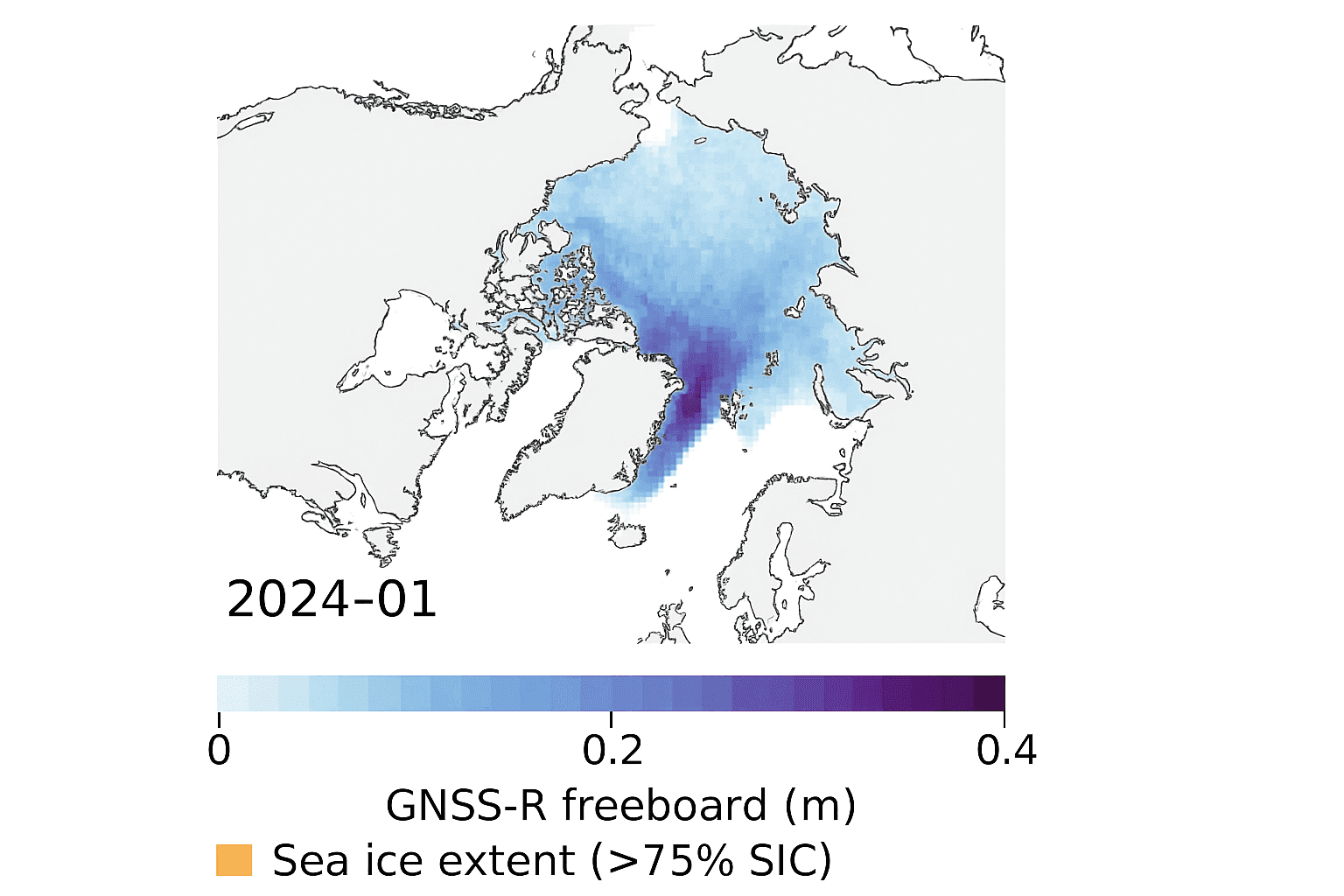
Leveraging GNSS-R from Spire’s constellation, the team derived ice freeboard across a full winter season. The GNSS-R maps reproduced the same broad spatial patterns seen in well-known altimetry products, including ESA’s CryoSat mission, supporting the use of commercial GNSS-R as an additional all-weather, day-or-night observing layer. At the same time, retrieval quality depends on surface conditions and favorable reflection behavior, with performance falling off when melt or other changes alter the scattering properties of sea ice.
The project was led by Felix Müller at the Technical University of Munich (DGFI-TUM) and Robert Ricker at the Norwegian Research Centre, both experts in GNSS-R. Spire Global contributed the GNSS-R measurements from its operational constellation and supported the generation of the Arctic-scale products, while the academic team directed method development, cross-comparison with reference datasets, and validation activities.
“GNSS signals are built for positioning, but once they scatter from Earth’s surface, their characteristics change. By examining those changes, we can infer properties of the surface,” Müller said.
“Earlier studies proved the concept,” Ricker added. “With Spire’s constellation, we set out to show large-scale performance by creating an Arctic-wide map of ice freeboard—the height of ice above the waterline.”
Inside Spire’s GNSS-R Constellation
Spire initially used its constellation for atmospheric profiling to support weather forecasting, then broadened into other Earth observation uses. The company began recording low-elevation reflections via grazing-angle GNSS-R, a geometry particularly well suited to observing ice.
The analysis spanned the Arctic Ocean and surrounding marginal seas—including the Beaufort, Chukchi, East Siberian, Laptev, Kara, Barents, Greenland, and Baffin Bay regions—from October 2023 through July 2024. These dates define the sea ice map series described here; additional periods may be produced as more observations are processed and made available. Data was delivered through ESA’s TPM program, which makes commercial and institutional datasets freely available for research and development; users typically access the Spire Global sea ice maps and related data through the TPM distribution channels by locating the Spire GNSS-R sea ice/freeboard dataset in the TPM catalog and completing any required user registration and terms acceptance before download.
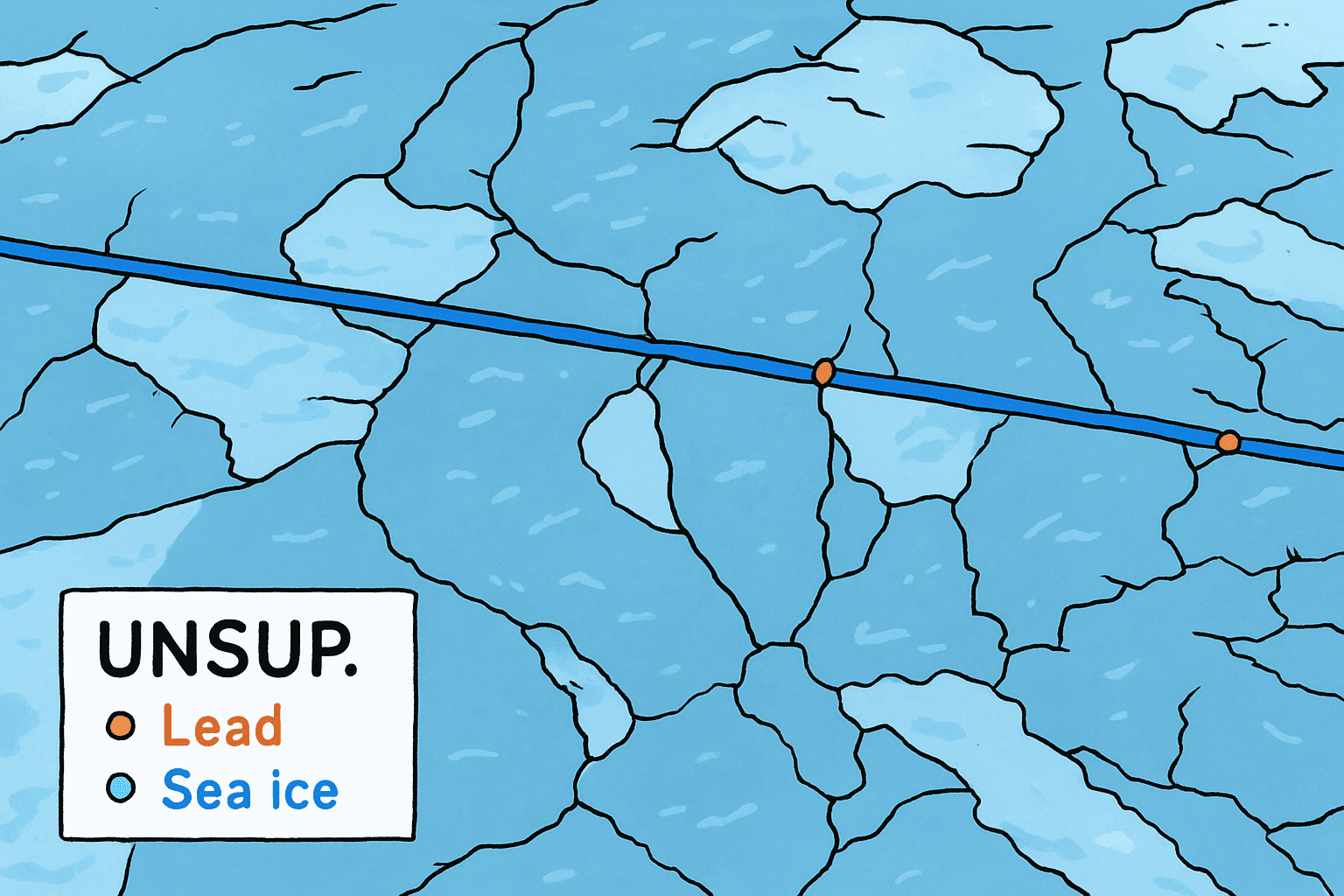
A key challenge in sea ice altimetry is reliably detecting narrow fractures called leads. These openings serve as reference points for estimating sea surface height and, by extension, freeboard.
Freeboard—the portion of sea ice that sits above the waterline—enables estimates of ice thickness, which is crucial for climate change assessment, sea-level estimation, and ocean–weather modeling. It is commonly inferred from remote sensing approaches (including radar/laser altimetry and GNSS-R) that analyze reflected-signal behavior over sea ice, and it can be checked against in situ observations such as upward-looking sonar.
Classifying Surface Conditions
“At the outset, we used two complementary methods to classify surface state from GNSS-R in order to find leads,” Müller said.
| Method | Description | Strengths | Limitations |
|---|---|---|---|
| Adaptive threshold technique | Evaluates reflected signal power to sort surfaces as water or ice. | Enables fast processing of the full GNSS-reflectometry dataset. Remains robust to changing signal conditions. | Uses a limited feature set, which can reduce the ability to separate more nuanced surface states. |
| Unsupervised clustering | Incorporates multiple signal features beyond power to draw finer distinctions among surface types, including identification of thin or refrozen ice. | Provides finer surface-type separation than power-only methods. | More computationally involved and dependent on feature behavior across variable conditions. |
Both approaches were compared with co-located CryoSat surface-type products and Sentinel-1 imagery, confirming that GNSS-R classifications were largely consistent with conventional satellite datasets.
Mapping Arctic Ice Freeboard
“Building on the classification work, we produced Arctic-wide freeboard maps from GNSS-R,” Ricker said.
The mapping workflow included the following processing steps:Correction for tides.Correction for sea surface height.Correction for atmospheric delays.Lead detection using enhanced algorithm.Calculation of sea surface height from lowest points.Subtraction of sea surface height from ice surface height to yield freeboard.Compilation into monthly gridded products.
The GNSS-R results showed strong agreement with CryoSat freeboard across much of the Arctic. Independent validation using upward-looking sonar in the Beaufort Sea further supported the accuracy of the retrieved values.
As expected, performance declined in spring when surface melt alters reflection behavior. Beyond seasonal sensitivity, modeled freeboard fields can be constrained by observation density, leaving higher uncertainty where reflections are sparse or unevenly distributed, and they can underrepresent fine-scale variability in highly fractured or rapidly changing ice. Many sea ice studies also use atmospheric reanalysis fields such as ERA-Interim to provide background environmental context and ancillary variables, but ERA-Interim’s comparatively coarse spatial detail and known challenges in polar boundary-layer conditions can miss localized gradients over sea ice, introducing additional uncertainty for this application.
The Contribution of Commercial Data
GNSS has long supported positioning, but this study shows how reflected-signal analysis extends its value to persistent Earth observation coverage, regardless of sunlight or weather, said Theresa Condor, Spire Global CEO.Public missions provide long-term benchmarks, and commercial constellations can add the sampling density needed to track rapid change between those benchmarks.
“Advances in miniaturization, digital signal processing, and machine learning have reshaped RF sensing,” Condor said. “Commercial constellations now deliver continuous, high-quality radio-frequency data that complement government systems with added flexibility and cost efficiency.”
“As environmental monitoring needs expand, agencies are increasingly incorporating commercially sourced RF datasets into operations, reflecting a maturing market and a growing role for commercial infrastructure,” she added.
“By releasing analysis-ready datasets, this effort represents a key milestone in moving grazing-angle GNSS-R from experimental to reliable for large-scale mapping of Arctic ice freeboard,” said Matthieu Talpe, Remote Sensing Product Engineer at Spire Global. “It strengthens the case for the grazing-angle technique used by the Spire constellation as a valuable complement to ESA and partner missions, helping close observational gaps in one of Earth’s fastest-changing regions.”


