
Why GIS Is Not a Load of Garbage


Introduction
A geographic information system (GIS) is one of the most sophisticated contemporary technologies to capture, analyze, and display spatial data (Chalkias and Lasaridi, 2011). Due to the nature of solid waste management operations, GIS provides an effective means to import, manage, and examine solid waste data. Planning and operating a successful solid waste management strategy requires collecting a large amount of solid waste data and assets with static or dynamic locations. This article highlights the use of GIS technology in modern solid waste management operations.
Data Collection
Basemap Information
Like most other GIS applications, developing a basemap to be used as a reference and a backdrop for solid waste operations is an essential first step. Data collection methodologies should primarily focus on layers related to environmental activities, such as soil type, hydrology, and land use. The following is an example of datasets that contribute to an effective basemap used in the field of solid waste management.
Basemap Datasets
Table 1. Example datasets contributing to a solid waste management basemap
Spatial Data Type Geometry
Road Network Vector Line
Administrative Boundaries Vector Polygon
Soils Vector Polygon
Hydrology Vector Point / Line / Polygon
Demographics (Census Data) Vector Polygon
Building Footprints Vector Polygon
Pedestrian Routes Vector Line
Mass Transit (Train Lines / Stations) Vector Line / Point
Land Use Vector Polygon
Aerial Photo / Satellite Imagery Raster Polygon
Spot Elevation / Contours / DEM Vector / Raster Polygon
Solid Waste Asset Data
Solid waste asset data relate to waste facilities and utilities used for collecting, transferring, and storing solid waste. Data are usually obtained from municipalities or solid waste contractors. Besides collecting the spatial location of these assets, gathering and documenting volumes, capacities, and compacting abilities of storage facilities is essential. A complete inventory of solid waste assets facilitates planning and estimating for waste generation studies.
Typical Solid Waste Asset Datasets
Table 2. Typical solid waste asset datasets
Spatial Data Type Geometry
Landfill Location Vector Polygon / Point
Transfer Station Vector Point
Underground Compactors Vector Point / Polygon
Ground Compactors Vector Point / Polygon
Waste Containers (Bins) Vector Point
Material Recovery Facility Vector Point / Polygon
Waste Generation and Characteristics
According to the California Department of Resources Recycling and Recovery (CalRecycle), solid waste generation rates estimate the amount of waste created by residences, businesses, and large events (e.g., severe weather or seismic occurrences) over a defined period. Waste generation includes all discarded materials, whether or not they are recycled or disposed of in landfills.
Waste generation depends on population size, workforce, visitor volume, and socio-economic factors. According to the World Bank What a Waste Report (2012), the waste generation rate per person ranges between 1.2 and 1.4 kilograms per day. Municipalities and event organizers typically conduct waste generation studies to estimate total waste volumes and weights.
Waste characterization is another critical dataset. It identifies waste composition such as plastics, paper, organics, metals, or glass. Each component requires different handling, processing, and recycling strategies. Waste characterization is fundamental to designing effective waste management systems.
Coding Asset Data and Using RFID for Geo-Referencing
Assets are the core of solid waste management operations. Each asset is assigned a unique identifier linking its spatial location with attributes such as capacity, compacting ability, and tonnage limits.
After coding assets, radio-frequency identification (RFID) tags can be mounted on them. RFID enables asset movement tracking and real-time monitoring. Tags may be attached to containers or compactors, transmitting location and status data when assets are full or relocated.
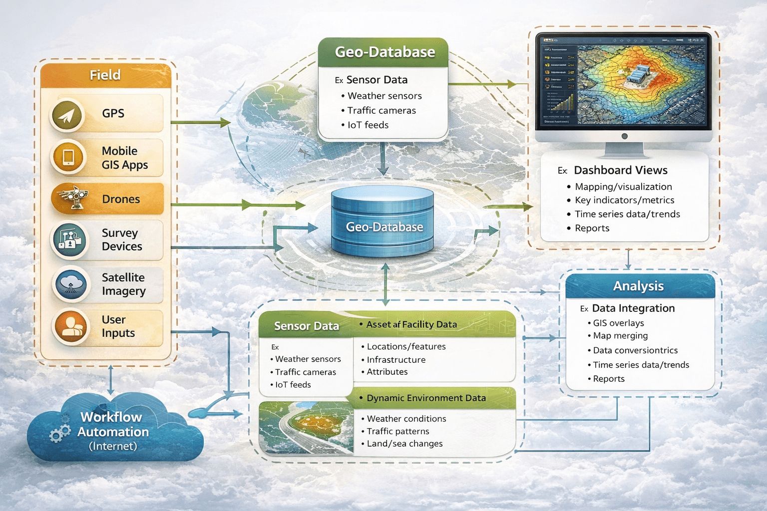
Integrated Approach
Integration of multiple solution components is critical to managing solid waste operations efficiently.
Spatial Database
A spatial database is the core of a GIS-based solid waste management solution. Basemap data, asset inventories, and operational metrics are stored centrally. Live data feeds from field operations allow real-time updates, automated alerts, and rapid incident reporting.
Field Operations
Field operations such as waste collection can be monitored using GIS-enabled technologies. RFID tags, GPS-equipped vehicles, and wireless connectivity allow transfer trucks to collect and transmit key data:
- Collection location (latitude and longitude)
- Collection time
- Waste weight and volume
- This integration improves operational efficiency and data accuracy.
- Dashboard View
Spatial dashboards provide a common operational picture. Managers can monitor asset status, predict compactor fill cycles, optimize collection schedules, and allocate resources more effectively.
Solid Waste and Spatial Analysis
Spatial analysis optimizes waste collection, processing, and asset placement. Advanced routing improves efficiency and reduces fuel consumption. GIS-based site selection supports decisions for compactors, transfer stations, and landfills based on accessibility, soil conditions, and environmental constraints.
Conclusion
GIS plays a critical role in modern solid waste management by supporting data collection, operational monitoring, routing optimization, and strategic planning. Although often overlooked, effective solid waste management is essential for maintaining healthy, sustainable, and environmentally responsible communities.
References
- Chalkias, C., & Lasaridi, K. (2011). Benefits from GIS-Based Modeling for Municipal Solid Waste Management.
- Karadimas, N. V., & Loumos, V. G. (2008). GIS-Based Modelling for the Estimation of Municipal Solid Waste Generation and Collection.
- Arebey, M., Hannan, M. A., Basri, H., Begum, R. A., & Abdullah, H. (2010). RFID and Integrated Technologies for Solid Waste Bin Monitoring Systems.
- The World Bank (2012). What a Waste: A Global Review of Solid Waste Management.
- California Department of Resources Recycling and Recovery (CalRecycle)


