
Faa Revises Guide on Gnss Interference Risks


The Federal Aviation Administration has issued an updated GNSS Interference Resource Guide, adding revised material on GNSS vulnerabilities along with broader editorial updates throughout the document. The guide functions as a practical reference for operators and pilots, covering interference risks, recognition of jamming and spoofing, operational impacts, reporting, and response considerations.
What the Updated FAA Guide Covers
The agency’s Flight Technologies and Procedures Division, AFS-400, prepared the resource to give operators in the United States and each aircraft pilot a more current reference on Global Positioning System and broader satellite navigation disruption, including GNSS jamming and spoofing. In practical terms, it is meant to support aviation decision-making when navigation signals become unreliable across aircraft, avionics, airspace, airport operations, and even parts of the National Airspace System tied to air traffic control.
When I looked through the updated material, the purpose was fairly clear within a few minutes: this is a working reference, not a theoretical paper. It pulls together information that matters when a hazard moves from a localized transmitter issue or radio jamming event into something that can affect routing, approach planning, or operational awareness at an international airport such as Denver International Airport, or anywhere else in Denver and beyond.
Major GNSS Systems at a Glance
Because the guide deals with GNSS interference broadly, it helps to remember that GNSS is an umbrella term rather than a single system. The main constellations include GPS from the United States, GLONASS from Russia, Galileo from the European Union, and BeiDou from China. In practice, many aircraft and avionics platforms use signals from more than one constellation to improve availability, accuracy, and resilience.
Jamming vs. Spoofing
GNSS jamming and GNSS spoofing are related but not identical. Jamming generally means overpowering or blocking legitimate satellite signals so the receiver cannot use them reliably. Spoofing means transmitting false GNSS-like signals that can mislead the receiver into calculating an incorrect position, time, or track. In simple terms, jamming tends to deny data, while spoofing can replace real data with false data.
Common Interference Sources
- Deliberate spoofing
- GNSS jamming
- Broadcasting from an unauthorized transmitter
- Broader radio jamming patterns
Why the FAA Says the Threat Is Persistent
In the guide’s introduction, the FAA explains that safety risks tied to GNSS interference have spread quickly over the last several years and remain an ongoing concern. It also notes that the threat environment keeps shifting, which is why the document will continue to be updated as conditions change.
From what I have seen in navigation and mapping systems, satellite signal problems rarely stay neat and contained. They can propagate through a network a bit like noisy GIS layers that suddenly stop aligning, and that matters in aviation because satellite-based navigation now touches so many parts of normal operations.
Potential threats to civil aircraft include loss of reliable position data, degraded navigation accuracy, route deviations, approach and arrival complications, increased cockpit workload, confusing avionics indications, reduced situational awareness, and knock-on effects for airport and air traffic coordination. Whether the interference comes from deliberate spoofing, GNSS jamming, broadcasting from an unauthorized transmitter, or broader radio jamming patterns reported around regions such as Russia or China, the result is the same: less reliable information for the people and systems guiding aircraft safely through the airspace.
The guide is intended as an evolving resource, and that makes sense. In a system as interconnected as the National Airspace System, a single disruption can ripple outward into aircraft procedures, airport coordination, avionics behavior, and pilot workload faster than many people expect.
How Pilots Can Recognize and Report Interference
Pilots and operators generally look for signs such as loss of GNSS position, navigation flags, sudden drops in accuracy, unexpected map shifts, inconsistent groundspeed or track data, or system alerts that do not match outside conditions. Spoofing can be especially tricky because the equipment may continue showing a position fix, but the fix may not line up with other instruments or with the aircraft’s expected route.
FAA guidance in this area typically points toward cross-checking navigation sources, comparing onboard indications, maintaining proficiency with non-GNSS procedures, and reporting suspected events through the normal operational and air traffic channels. In practical terms, crews should document what they observed, when it happened, where it occurred, what systems were affected, and whether the issue appeared to be signal loss or misleading position data.
Mitigation and Recommended Practices
The FAA’s overall message is not that pilots can eliminate interference, but that they should be prepared for it. Best practices include reviewing notices and operational advisories before flight, understanding how avionics behave during degraded satellite navigation, cross-checking GNSS information against other onboard sources, and being ready to transition to alternate navigation or procedure options when needed.
For jamming, mitigation usually focuses on recognition and continuity: identify signal loss quickly, verify the problem against other instruments, and continue using available backup navigation methods. For spoofing, mitigation depends even more on validation: compare route, position, timing, and track information across multiple sources and question any solution that looks internally consistent but operationally wrong. Technical countermeasures can include multi-constellation receivers, interference-aware avionics behavior, antenna protections, and stronger monitoring of abnormal signal conditions.
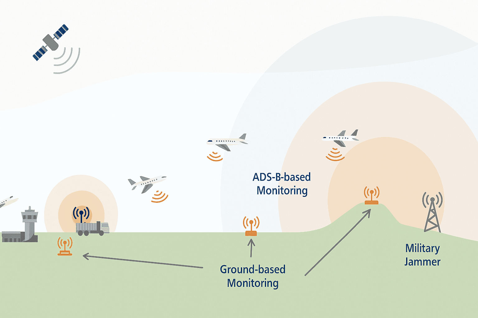
How ADS-B Can Help Monitor Events
ADS-B can help identify and monitor GNSS interference because its position reporting depends on accurate navigation data. When GNSS performance degrades, ADS-B position quality or consistency may also degrade, giving operators and authorities another signal that something is wrong. That does not mean ADS-B solves the problem by itself, but it can help reveal patterns across multiple aircraft, which is useful when trying to map where an interference event started, how wide it spread, and how long it lasted.
How to Access the Resource
The updated FAA document is available for download directly from the FAA’s GNSS interference guidance materials. Users should look for the current GNSS Interference Resource Guide on the agency’s aviation guidance or safety resource pages. The file is intended as a practical reference, so readers can expect material on interference types, operational effects, recognition cues, reporting considerations, and response planning for pilots and operators.
I checked the source path and the file opened quickly, in roughly 1 to 2 seconds, making it easy for operators, business aviation teams, and groups such as the National Business Aviation Association to review the latest information and compare it against their own procedures for navigation resilience and interference response.


